Tosa-Kitagawa Station
Railway station in Ōtoyo, Kōchi Prefecture, Japan
33°42′53″N 133°41′11″E / 33.714757°N 133.686333°E / 33.714757; 133.686333Location | |
|---|---|
  Tosa-Kitagawa Station Location within Kochi Prefecture Show map of Kochi Prefecture Tosa-Kitagawa Station Tosa-Kitagawa Station (Japan) Show map of Japan |
Tosa-Kitagawa Station (土佐北川駅, Tosa-Kitagawa-eki) is a passenger railway station located in the town of Ōtoyo, Nagaoka District, Kōchi Prefecture, Japan. It is operated by JR Shikoku and has the station number "D33".[1][2]
Lines
The station is served by the JR Shikoku Dosan Line and is located 93.3 km from the beginning of the line at Tadotsu.[3][4]
Layout
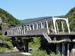
The station, which is unmanned, consists of a narrow island platform serving two tracks all mounted on an iron bridge spanning the Ananai River. From both the north and south ends of the bridge, stairs lead up to a pedestrian walkway along the length of the bridge which gives access to the platform. At an intermediate landing up the steps on the south side, a waiting room has been established.[2][5]
-
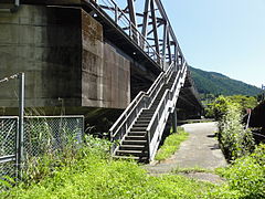 Station entrance on the north side of the bridge. The stairs lead to a walkway which runs along the length of the bridge.
 -
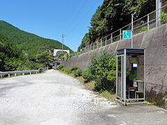 Access to the entrance on the south side of the bridge is via a gravel footpath. A public telephone call box has been installed. A toilet building can also be seen in the background.
 -
 The stairs on the south side lead up to the walkway along the bridge.
 -
 At a landing under the bridge on the south side, a waiting room has been installed.


Adjacent stations
| « | Service | » | ||
|---|---|---|---|---|
| Dosan Line | ||||
| Ōsugi | - | Kakumodani | ||
History
The station opened on 1 October 1960 on the existing Dosan Line but at a different location further to the south. After track re-alignment works, the station was moved to its present location on 3 March 1986. At this time the station was operated by Japanese Government Railways, later becoming Japanese National Railways (JNR). With the privatization of JNR on 1 April 1987, control of the station passed to JR Shikoku.[3][6]
Surrounding area
- Japan National Route 32
See also
References
- ^ "Shikoku Railway Route Map" (PDF). JR Shikoku. Retrieved 25 November 2017.
- ^ a b "土佐北川" [Tosa-Kitagawa]. hacchi-no-he.net. Retrieved 17 December 2017.
- ^ a b Ishino, Tetsu; et al., eds. (1998). 停車場変遷大事典 国鉄・JR編 [Station Transition Directory – JNR/JR] (in Japanese). Vol. II. Tokyo: JTB Corporation. p. 666. ISBN 4-533-02980-9.
- ^ "Tosa-Kitagawa Station Timetable" (PDF). JR Shikoku. Retrieved 17 December 2017.
- ^ "土佐北川駅" [Tosa-Kitagawa Station]. shikoku.org.uk. Retrieved 17 December 2017.
- ^ Ishino, Tetsu; et al., eds. (1998). 停車場変遷大事典 国鉄・JR編 [Station Transition Directory – JNR/JR] (in Japanese). Vol. I. Tokyo: JTB Corporation. pp. 217–218. ISBN 4-533-02980-9.
External links
Wikimedia Commons has media related to Tosa-Kitagawa Station.
- JR Shikoku timetable (in Japanese)
- v
- t
- e
Stations of the JR Shikoku D K Dosan Line
- Tadotsu
- Konzōji
- Zentsūji
- Kotohira
- Shioiri
- Kurokawa
- Sanuki-Saida
- Tsubojiri
- Hashikura
- Tsukuda
- Awa-Ikeda
- Minawa
- Iyaguchi
- Awa-Kawaguchi
- Koboke
- Ōboke
- Tosa-Iwahara
- Toyonaga
- Ōtaguchi
- Tosa-Ananai
- Ōsugi
- Tosa-Kitagawa
- Kakumodani
- Shigetō
- Shingai
- Tosa-Yamada
- Yamada-Nishimachi
- Tosa-Nagaoka
- Gomen
- Tosa-Ōtsu
- Nunoshida
- Tosa-Ikku
- Azōno
- Kōchi
- Iriake
- Engyōjiguchi
- Asahi
- Kōchi-Shōgyō-Mae
- Asakura
- Edagawa
- Ino
- Hakawa
- Omurajinjamae
- Kusaka
- Okabana
- Tosa-Kamo
- Nishi-Sakawa
- Sakawa
- Erinono
- Togano
- Asō
- Ōnogō
- Ōma
- Susaki
- Tosa-Shinjō
- Awa
- Tosa-Kure
- Kageno
- Rokutanji
- Niida
- Kubokawa


