Tsentralnyi District, Dnipro
Urban district in Dnipro Municipality, Ukraine
Tsentralnyi District Центральний район | |
|---|---|
| Coordinates: 48°28′00″N 35°02′00″E / 48.46667°N 35.03333°E / 48.46667; 35.03333 | |
| Country |  Ukraine Ukraine |
| Municipality | Dnipro Municipality |
| Established | 1932[1] |
| Area | |
| • Total | 10.403 km2 (4.017 sq mi) |
| Population (2001 census) | |
| • Total | 71,115 |
| • Density | 6,800/km2 (18,000/sq mi) |
| Time zone | UTC+2 (EET) |
| • Summer (DST) | UTC+3 (EEST) |
| Area code | +380 562 |
| KOATUU | 1210137500[3] |
|  |
Tsentralnyi District (Ukrainian: Центральний район) is an urban district of the city of Dnipro, in southern Ukraine.[4] It is located in the city's center and on the right-bank of the Dnieper River.
History
The district was created in 1932 as the Tsentralnyi Nahornyi District.[1] on 2 December 1934, after the death of Sergei Kirov, it was renamed as the Kirovskyi District.[1] In 1936 the eastern part of district became the Zhovtnevyi District. In 1973 more territories of the Kirovskyi District were passed to the newly formed Babushkinskyi District. The district gained its current name, Tsentralnyi District, on 27 November 2015 when it was renamed as part of Ukraine's decommunization campaign.[5]
Population
Language
Distribution of the population by native language according to the 2001 census:[6]
| Language | Number | Percentage |
|---|---|---|
| Ukrainian | 26 332 | 37.03% |
| Russian | 43 988 | 61.85% |
| Other[a] | 795 | 1.12% |
| Total | 71 115 | 100.00% |
| a Those who did not indicate their native language or indicated a language that was native to less than 1% of the local population. |
Gallery
-
 Lazar Hloba Park in Tsentralnyi District
 -
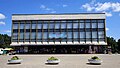
 Modern buildings in central part of Dnipro
 -
 National academic Theatre of opera and ballet
 -
 Dnipro railway station and surrounding buildings
 -
![Stalinist architecture on the Dmytro Yavornytsky Avenue [uk; ru; de]](//upload.wikimedia.org/wikipedia/commons/thumb/f/f5/Stalinist_Architecture_Dnipropetrovsk.jpg/120px-Stalinist_Architecture_Dnipropetrovsk.jpg) Stalinist architecture on the Dmytro Yavornytsky Avenue [uk; ru; de]
Stalinist architecture on the Dmytro Yavornytsky Avenue [uk; ru; de]


![Stalinist architecture on the Dmytro Yavornytsky Avenue [uk; ru; de]](http://upload.wikimedia.org/wikipedia/commons/thumb/f/f5/Stalinist_Architecture_Dnipropetrovsk.jpg/120px-Stalinist_Architecture_Dnipropetrovsk.jpg)
References
- ^ a b c "Historical Background of Tsentralnyj Raion". Official Internet-portal (in Ukrainian). Dnipro City Council. Retrieved 25 July 2017.
- ^ "Kirovskyi Raion". gorod.dp.ua/ (in Ukrainian). Retrieved 4 February 2015.
- ^ "Kirovskyi District Council". Informational portal of the self-government in Ukraine (in Ukrainian). Rada.info. Retrieved 5 February 2015.
- ^ "Kirovskyi Raion, Dnipropetrovsk Oblast, City of Dnipropetrovsk". Regions of Ukraine and their Structure (in Ukrainian). Verkhovna Rada of Ukraine. Retrieved 4 February 2015.
- ^ "In Dnepropetrovsk, the main highways and five districts of the city were renamed" (in Ukrainian). depo.ua. Retrieved 27 November 2015.
- ^ "Рідні мови в об'єднаних територіальних громадах України" (in Ukrainian).
External links
Wikimedia Commons has media related to Centralny District, Dnipro.
- Tsentralnyi Raion at the Dnipro City Council website (in Ukrainian)
- v
- t
- e

| Right-bank1 |
|
|---|---|
| Left-bank1 |
|
- 1Non-administrative neighborhoods
- 2Urban-type settlement until September 2001
- Category:Dnipro
 | This article about a location in Dnipropetrovsk Oblast is a stub. You can help Wikipedia by expanding it. |
- v
- t
- e


