Tytuvėnai Regional Park
Tytuvėnai Regional Park was established in 1992 to preserve the hilly, marshy, laky landscape and the historical Šiluva and Tytuvėnai urban monuments in Lithuania. Parks administration and information center is located in Tytuvėnai, Miško street - 3.[1]
Territory
The park is situated in Raseiniai, Radviliškis and Kelme district junction in the middle west of Lithuania, Šiauliai county, Samogitia. The park territory is 18159 ha (181km2) of which 45% forests, 10% wetlands, 2% lakes, 42% other territories.[2]
Landscape
Expressive hilly, lake and swampy landscapes are the part of ice age heritage. Wavy hilly plains turn into lowlands, forming massive peatbogs. Viscous forests of Užpelkiai are located in a place of ice age lagoon, graceful sand hills and rocky pine forests. Spacious wetlands here are called Tyruliai.[3]
-
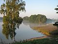
 Gilius lake at a summer evening
 -
 E. Damaševičiaus alley in winter
 -
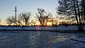 Bridvaišis lake beach in winter
 -
 Bridvaišis lake in autumn
 -
 Bridvaišis lake viewed from a small castle hill
 -
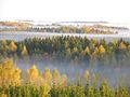 Tytuvėnai Regional Park photo taken from a watch tower
 -
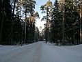
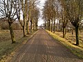 Road towards Bridvaišis lake on autumn
 -
 Tytuvėnai Regional Park landscape


Cultural heritage
The most famous cultural object in Tytuvenai is the church and monastery architectural ensemble from the 17th century. Spacious yard, surrounded by closed Lithuanian gallery, with a chapel with steps in the center, by which those who come to pray go up. In a monastery in authentic monks’ cells many fresco paintings are made. Splendid chapel of Šiluva is built upon the project of well-known architect Antanas Vivuliškis. Here there is also an attractive old market square with several old wooden houses surrounding it. The numerous pagan memorials include Bridvaišis, Šiauleliai, Pašakarnėlis and Kudinis castle hills, Kuršis, Debeikis, Rinkšelis tumuluses (burial mounds), as well as former shrine of pagans – Saint Jurgis Hill.[4]

References
Official website in English
Notes
- ^ "Information about the park > History". Kelmė District Municipality page. Retrieved 2016-12-29.
- ^ "Information about the regional park > Territory". Kelmė District Municipality page. Retrieved 2016-12-29.
- ^ "About the park > Landscape". Tytuvėnai Regional Park official website. Retrieved 2016-12-29.
- ^ "About the Park > Culture". Tytuvėnai Regional Park official website. Retrieved 2016-12-29.
55°35′N 23°15′E / 55.583°N 23.250°E / 55.583; 23.250
- v
- t
- e
Anykščiai RP - Asveja RP - Aukštadvaris RP - Biržai RP - Dieveniškės HRP - Dubysa RP - Gražutė RP - Kaunas Reservoir RP - Krekenava RP - Kurtuvėnai RP - Labanoras RP - Meteliai RP - Nemunas Delta RP - Nemunas Loops RP - Neris RP - Pagramantis RP - Pajūris RP - Panemuniai RP - Pavilniai RP - Rambynas RP - Salantai RP - Sartai RP - Sirvėta RP - Tytuvėnai RP - Varniai RP - Veisiejai RP - Venta RP - Verkiai RP - Vištytis RP - Žagarė RP
| Authority control databases |
|
|---|


