Uithuizermeeden
Village in Groningen, Netherlands

Flag

Coat of arms
53°24′52″N 6°43′35″E / 53.41444°N 6.72639°E / 53.41444; 6.72639
(2021)[1]
9982[1]
Uithuizermeeden is a village in the Netherlands, with a population of about 3,200 people. It is part of the municipality of Het Hogeland, close to the Wadden Sea.
The most important points are the Meijster Toren and the Rensumaborg (dated 1700, not open for public). The Meijster Toren dated from the thirteenth century, but was rebuilt at the end of the 19th century in original style, after a fire destroyed it.
It had a population of around 3,325 in January 2017.[3]
Uithuizermeeden was a separate municipality until 1979, when it became part of Hefshuizen.[4]
Gallery
-
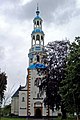 Church of Uithuizermeeden.
 -
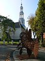 Church and sculpture Fish by Jaap Meeuwen
 -
 Rensumaborg, ca. 1500; front


References
- ^ a b c "Kerncijfers wijken en buurten 2021". Central Bureau of Statistics. Retrieved 8 April 2022.
- ^ "Postcodetool for 9982AA". Actueel Hoogtebestand Nederland (in Dutch). Het Waterschapshuis. Retrieved 8 April 2022.
- ^ Kerncijfers wijken en buurten 2017 - CSB Statline
- ^ Ad van der Meer and Onno Boonstra, Repertorium van Nederlandse gemeenten, KNAW, 2011.
External links
![]() Media related to Uithuizermeeden at Wikimedia Commons
Media related to Uithuizermeeden at Wikimedia Commons
- the Digitale Village Uithuizermeeden
- v
- t
- e
Populated places in the municipality of Het Hogeland
- Adorp
- Den Andel
- Baflo
- Bedum
- Eenrum
- Hornhuizen [nl]
- Houwerzijl
- Kantens
- Kleine Huisjes
- Kloosterburen
- Lauwersoog
- Leens
- Mensingeweer
- Niekerk [nl]
- Noordwolde
- Oldenzijl
- Onderdendam
- Oosteinde
- Oosternieland
- Oudeschip
- Pieterburen
- Rasquert [nl]
- Roodeschool
- Rottum
- Saaxumhuizen [nl]
- Sauwerd
- Stitswerd
- Tinallinge [nl]
- Uithuizen
- Uithuizermeeden
- Ulrum
- Usquert
- Warffum
- Warfhuizen
- Wehe-den Hoorn
- Westernieland
- Wetsinge
- Winsum
- Zandeweer
- Zoutkamp
- Zuidwolde
- Zuurdijk [nl]
| Authority control databases: Geographic |
|
|---|
 | This Groningen location article is a stub. You can help Wikipedia by expanding it. |
- v
- t
- e


