Valdresflye
Mountain plateau in the Jotunheimen mountains, Norway


Valdresflye
Location of the mountain
Show map of Innlandet
Valdresflye
Valdresflye (Norway)
Show map of NorwayValdresflye, also spelled Valdresflya and Valdresflyi, is a mountain plateau in the easternmost part of the Jotunheimen mountains in Norway. The plateau lies in Innlandet county, mostly in Øystre Slidre Municipality, but a small area extends into Vang Municipality as well. The Norwegian County Road 51 runs over the plateau, reaching 1,389 meters (4,557 ft) above mean sea level, but this road is only open in the summers.[2][3]
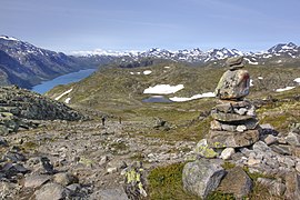
The plateau is surrounded by several mountains including Gråhøi to the east, Heimdalshøe to the northeast, Tjønnholstinden to the northwest, and Rasletinden to the west. The lakes Bygdin and Vinstre lie along the south side of the plateau.
Name
The plateaus is named Valdresflye. The first element is the name of the district Valdres in which it is located. The last element is the finite form of fly which means 'flat mountain plateau'.
Media gallery
-
 Seen from the north in the direction of Bygdin
 -
 The plateau in October
 -
 View of Bandet
 -
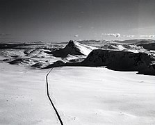
 Road over Valdresflya


See also
References
- ^ "Valdresflye, Øystre Slidre" (in Norwegian). yr.no. Retrieved 2022-02-12.
- ^ "Nasjonal turistveg Valdresflye" (in Norwegian). Norwegian Public Roads Administration. Archived from the original on 12 April 2011. Retrieved 5 October 2011.
- ^ Thorsnæs, Geir, ed. (2021-10-05). "Valdresflye". Store norske leksikon (in Norwegian). Kunnskapsforlaget. Retrieved 2022-06-01.
- v
- t
- e


