Vatutine
City in Cherkasy Oblast, Ukraine
You can help expand this article with text translated from the corresponding article in Ukrainian. (July 2022) Click [show] for important translation instructions.
- Machine translation, like DeepL or Google Translate, is a useful starting point for translations, but translators must revise errors as necessary and confirm that the translation is accurate, rather than simply copy-pasting machine-translated text into the English Wikipedia.
- Do not translate text that appears unreliable or low-quality. If possible, verify the text with references provided in the foreign-language article.
- You must provide copyright attribution in the edit summary accompanying your translation by providing an interlanguage link to the source of your translation. A model attribution edit summary is
Content in this edit is translated from the existing Ukrainian Wikipedia article at [[:uk:Ватутіне]]; see its history for attribution. - You may also add the template
{{Translated|uk|Ватутіне}}to the talk page. - For more guidance, see Wikipedia:Translation.
City in Cherkasy Oblast, Ukraine
Vatutine Ватутіне | |
|---|---|
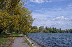 City park | |
 Flag  Coat of arms | |
49°00′43″N 31°04′17″E / 49.01194°N 31.07139°E / 49.01194; 31.07139 | |
| Country |  Ukraine Ukraine |
| Oblast | Cherkasy Oblast |
| Raion | Zvenyhorodka Raion |
| Hromada | Vatutine urban hromada |
| Founded | 1947 |
| City status | 1952 |
| Government | |
| • Mayor | Oleksandr Zaborovets |
| Area | |
| • Total | 1,089 km2 (420 sq mi) |
| Elevation | 127 m (417 ft) |
| Population (2022) | |
| • Total | 15,763 |
| • Density | 14/km2 (37/sq mi) |
| [1] | |
| Postal code | 20250 |
| Area code | +380-4740 |
Vatutine (Ukrainian: Ватутіне, [wɐˈtutʲine]) is a city in Zvenyhorodka Raion, Cherkasy Oblast (region) of Ukraine. It hosts the administration of Vatutine urban hromada, one of the hromadas of Ukraine.[2] It had a population of 15,763 (2022 estimate).[1]
Administrative status
Vatutine gained status as a city in 1952.[3] Until 18 July 2020, Vatutine was designated as a city of oblast significance and belonged to Vatutine Municipality but not to any raion. As part of the administrative reform of Ukraine, which reduced the number of raions of Cherkasy Oblast to four, the city was merged into Zvenyhorodka Raion.[4][5]
History
The city was founded in 1946.[citation needed]
Demographics
In January 1989, the population of the city was 20, 362 people.[6][3] In January 2013, the population of the city was 17, 653 people.[7]
Language
Distribution of the population by native language according to the 2001 census:[8]
| Language | Number | Percentage |
|---|---|---|
| Ukrainian | 18 362 | 91.69% |
| Russian | 1 594 | 7.96% |
| Other[a] | 71 | 0.35% |
| Total | 20 027 | 100.00% |
| a Those who did not indicate their native language or indicated a language that was native to less than 1% of the local population. |
See also
References
- ^ a b Чисельність наявного населення України на 1 січня 2022 [Number of Present Population of Ukraine, as of January 1, 2022] (PDF) (in Ukrainian and English). Kyiv: State Statistics Service of Ukraine. Archived (PDF) from the original on 4 July 2022.
- ^ "Ватутінська територіальна громада" (in Ukrainian). decentralization.gov.ua.
- ^ a b Ватутино // Большой энциклопедический словарь (в 2-х тт.). / редколл., гл. ред. А. М. Прохоров. том 1. М., "Советская энциклопедия", 1991. стр.197
- ^ "Про утворення та ліквідацію районів. Постанова Верховної Ради України № 807-ІХ". Голос України (in Ukrainian). 2020-07-18. Retrieved 2020-10-03.
- ^ "Нові райони: карти + склад" (in Ukrainian). Міністерство розвитку громад та територій України.
- ^ Всесоюзная перепись населения 1989 г. Численность городского населения союзных республик, их территориальных единиц, городских поселений и городских районов по полу
- ^ Чисельність наявного населення України на 1 січня 2013 року. Державна служба статистики України. Київ, 2013. стор.105
- ^ "Рідні мови в об'єднаних територіальних громадах України" (in Ukrainian).
- v
- t
- e

- Babanka
- Balakleia
- Bashtechky
- Berezniaky
- Bilozirya
- Bobrytsia
- Budyshche
- Buky
- Buzhanka
- Cherkasy
- Chervona Sloboda
- Chornobai
- Chyhyryn
- Dmytrushky
- Drabiv
- Helmiaziv
- Horodyshche
- Irkliiv
- Ivanky
- Kamianka
- Kaniv
- Katerynopil
- Khrystynivka
- Korsun-Shevchenkivskyi
- Ladyzhynka
- Lesky
- Lipliave
- Lypianka
- Lysianka
- Mankivka
- Matusiv
- Medvedivka
- Mliiv
- Mokra Kalyhirka
- Monastyryshche
- Moshny
- Mykhailivka
- Nabutiv
- Nova Dmytrivka
- Palanka
- Pishchane
- Rotmistrivka
- Ruska Poliana
- Sahunivka
- Selyshche
- Shevchenkove
- Shpola
- Shramkivka
- Smila
- Stebliv
- Stepanky
- Stepantsi
- Talne
- Ternivka
- Uman
- Vatutine
- Velyky Khutir
- Vilshana
- Vodianyky
- Voznesenske
- Vynohrad
- Yerky
- Zhashkiv
- Zolotonosha
- Zorivka
- Zvenyhorodka
Authority control databases | |
|---|---|
| International |
|
| Other |
|


