Walbury Hill
Hill in, and highest point of, the English county of Berkshire


Walbury Hill
Walbury Hill in Berkshire
Walbury Hill is a summit of the North Wessex Downs in Berkshire, England. With an elevation of 297 metres (974 ft), it is the highest natural point in South East England.[note 1] On the hill's summit is the Iron Age hill fort of Walbury Camp, whilst the flanks of the hill lie within the Inkpen and Walbury Hills SSSI. The hill is one of three nationally important chalk wild grasslands in the North Wessex Downs, the others being in the Rushmore and Conholt Downs SSSI and the Hog's Hole SSSI. The summit of the hill is marked by a triangulation pillar, but lies on private land with no public access, although public access is available to the north of the summit via a byway.[1][2][3]
Walbury Hill lies on the north-facing ridgeline of the North Hampshire Downs section of the North Wessex Downs, flanked to the west by Inkpen Hill and to the east by Combe Hill and Pilot Hill. Combe Gibbet stands to the west on Gallows Down between Walbury and Inkpen Hills. The town of Hungerford is around seven kilometres (4+1⁄2 mi) northwest.[1][3][4]
The hill is accessible by minor roads at both its western and eastern sides, and there are car parks at the closest point of approach of each road. There is no paved road across the hill between these two points, but a byway open to all traffic connects them, passing some 200 metres (660 ft) north of the summit. The westerly car park at Walbury Hill is the starting point for both the Test Way and the Wayfarer's Walk long distance footpaths. The Wayfarer's Walk utilises the byway across the hill, before continuing south and east to Emsworth in Hampshire. The Test Way heads in the opposite direction, via Combe Gibbet and Inkpen Hill, before turning south to Eling in Hampshire.[1][3][4]
The hill lies within the civil parishes of Combe (which includes the summit), Inkpen and West Woodhay, all of which are within the unitary authority area of West Berkshire and the ceremonial county of Berkshire.[note 2] It forms part of the Kirby House estate, owned by the Astor family.[3][5]
Before the use of satellites was commonplace, Walbury Hill was occasionally used by the BBC as a temporary relay station during events at Newbury Racecourse. There is a small low-level circular brick building, approximately 6 feet (1.8 metres) high, on the south side of the hill, which appears to be a disused reservoir.[citation needed]
Gallery
-
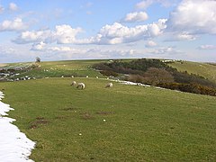 View of Walbury Hill from Combe Gibbet to the west
 -
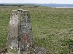 The triangulation pillar, looking west towards Coombe Gibbet
 -
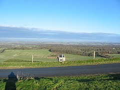 View looking north from Walbury Hill Car Park
 -
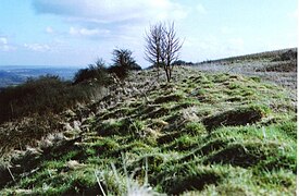 The remains of the hill fort


Notes
- ^ Walbury Hill is 3 metres (10 ft) higher than Leith Hill in Surrey.
- ^ The summit of Walbury Hill became part of Berkshire when the civil parish of Combe was transferred from Hampshire in 1895. Pilot Hill, two miles (three kilometres) southeast, is now the highest point in Hampshire.
References
Wikimedia Commons has media related to Walbury Hill.
- ^ a b c d Bathurst, David (2012). Walking the county high points of England. Chichester: Summersdale. pp. 148–154. ISBN 978-1-84-953239-6.
- ^ "Facts about South East England".
- ^ a b c d Explorer 158: Newbury & Hungerford (Map). Ordnance Survey. ISBN 9780319243510.
- ^ a b "North Wessex Downs Area of Outstanding Natural Beauty - Integrated Landscape Character Assessment" (PDF). Archived from the original (PDF) on 6 February 2017. Retrieved 5 February 2017.
- ^ "The thirty landowners who own half a county". Who owns England?.
- v
- t
- e
- Black Head
- Cadson Bury
- Caer Bran
- Castallack Round
- Castle an Dinas
- Castle Dore
- Castle Goff
- Chûn Castle
- Dodman Point
- Giant's Castle
- Kelly Rounds
- Kelsey Head
- Lescudjack
- Lesingey Round
- Maen Castle
- Padderbury Top
- Prideaux Castle
- Rame Head
- The Rumps
- Trencrom Hill
- Trereen Dinas
- Treryn Dinas
- Trevelgue Head
- Warbstow Bury
- Ashleys Copse
- Buckland Rings
- Bury Hill
- Caesar's Camp
- Castle Hill
- Chilworth Ring
- Danebury
- Dunwood Camp
- Frankenbury Camp
- The Frith
- Gorley Hill
- Hamble Common Camp
- King John's Hill
- Knoll Camp
- Ladle Hill
- Lockerley Camp
- Norsebury Ring
- Old Winchester Hill
- Oram's Arbour
- Quarley Hill
- St. Catherine's Hill
- Tidbury Ring
- Toothill Fort
- Whitsbury Castle
- Woolbury
- Bayston Hill
- Bury Ditches
- Bury Walls
- Caer Caradoc, Church Stretton
- Caer Caradog, Chapel Lawn
- Caus Castle
- Coxall Knoll
- Nordy Bank
- Old Oswestry
- The Wrekin
- Carl Wark
- Wincobank
- Ashleys Copse
- Barbury Castle
- Battlesbury Camp
- Bratton Castle
- Bury Camp
- Castle Ditches
- Casterley Camp
- Castle Rings
- Chisbury
- Chiselbury
- Chisenbury Camp
- Clearbury Ring
- Cley Hill
- Fosbury Camp
- Grovely Castle
- Knook Castle
- Liddington Castle
- Membury Camp
- Old Sarum
- Ringsbury Camp
- Roundway Down
- Scratchbury Camp
- Sidbury Hill
- Vespasian's Camp
- Winkelbury Camp
- Yarnbury Castle


