
Wyler Aerial Tramway is an aerial tramway in El Paso, Texas, United States. The tramway is operated by the Texas Parks and Wildlife Department and is located in Franklin Mountains State Park. The tramway complex covers 196 acres (0.79 km2) on the east side of the Franklin Mountains. The gondolas travel along two 2600 foot 1 3/8" diameter steel cables to Ranger Peak, 5,632 feet (1,717 m) above sea level. The trip takes about four minutes and lifts riders up 940 vertical feet above the boarding area. From Ranger Peak viewers can see three states and two countries on a clear day.[1] The tramway was closed indefinitely to the public in September 2018.
History
[edit]The tramway was built in 1959 by KTSM radio to aid in the construction of a transmitter tower. Karl O. Wyler managed the project. First opening to the public as the El Paso Aerial Tramway, the facility provided rides from 1960 to 1986, when high liability insurance costs forced the tram to stop public operations. The tram was only used to service the transmitter towers. Wyler donated the tramway for public use in his will. The Texas Parks and Wildlife Department accepted the donation in 1997 and renovated and re-opened the tramway to the public in 2001. The tramway was closed indefinitely in September 2018 after the Texas Parks and Wildlife conducted an engineering analysis that concluded "the tram has surpassed its life expectancy and is no longer suited for public use." TPWD estimated the replacement of the tram would cost millions of dollars and the agency did not have the financial resources to execute a capital construction project of this size at that time.[2] In July 2024, it was announced that plans for repairs of the tramway were underway.[3]
Gallery
[edit]-
 Wyler Aerial Tramway
 -
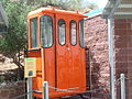 Old Tramway gondola
 -
 Ranger Peak with a view of Northeast El Paso in the background
 -
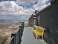
 Ranger Peak gift shop
 -
 Inside gift shop
 -
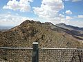 Looking north at the Franklin Mountains from Ranger Peak
 -
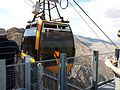
 Current gondola
 -
 The tramway


References
[edit]- ^ "Wyler Aerial Tramway — Texas Parks & Wildlife Department".
- ^ TPWD News Release announcing closure
- ^ Burge, Dave (28 July 2024). "Officials: Plans to bring Wyler tramway back moving ahead". KTSM 9 News. Archived from the original on 28 July 2024. Retrieved 29 July 2024.
External links
[edit]- Wyler Aerial Tramway
- Summitpost.org - Ranger Peak
- Home movie of the Franklin Mountains State Park from the Sandoval Family on the Texas Archive of the Moving Image
31°48′32″N 106°28′41″W / 31.80889°N 106.47806°W

This article related to a protected area in Texas is a stub. You can help Wikipedia by expanding it. |
This article about transportation in Texas is a stub. You can help Wikipedia by expanding it. |