Ye, Myanmar
Town in Mon State, Myanmar
Ye ရေး ရေဝ် | |
|---|---|
Town | |
  | |
| 15°14′48″N 97°51′20″E / 15.24667°N 97.85556°E / 15.24667; 97.85556 | |
| Country |  Myanmar Myanmar |
| Division |  Mon State Mon State |
| District | Ye |
| Population (2014) | 34,430 |
| • Ethnicities | Mon |
| • Religions | Buddhism |
| Time zone | UTC+6.30 (MST) |
Ye (Burmese: ရေးမြို့, IPA: [jé mjo̰]) is a town in the southern end of Mon State, Myanmar (Burma). It is the principal town of Ye Township of Mawlamyine District. The town is located by the Ye River as it drains into the Gulf of Martaban, and is surrounded by Tenasserim Hills in the east. It has warm, moderate weather. The town's economy is mainly based on betel nut, rubber, fishery production, and trade. Ye is on the Mawlamyaing-Dawei rail line, and has a seaport. The majority of the people are ethnic Mon people. Ye is a center of Mon language education. As of 2014, it had a population of 34,430.[1]
There was a flood in August 2011 after a torrent of rain (12.6 inches on 1 August). 2,000 houses were flooded and some schools and markets were closed because of it.[2]
Climate
Ye has a tropical monsoon climate (Köppen climate classification Am). Temperatures are hot throughout the year, although maximum temperatures in the monsoon months are depressed by heavy cloud and rain. There is a winter dry season (November–April) and a summer wet season (May–October). Torrential rain falls from June to September, with over 1,200 millimetres (47 in) falling in August alone.
| Climate data for Ye (1991–2020) | |||||||||||||
|---|---|---|---|---|---|---|---|---|---|---|---|---|---|
| Month | Jan | Feb | Mar | Apr | May | Jun | Jul | Aug | Sep | Oct | Nov | Dec | Year |
| Mean daily maximum °C (°F) | 33.5 (92.3) | 34.8 (94.6) | 35.6 (96.1) | 35.9 (96.6) | 33.0 (91.4) | 30.4 (86.7) | 29.5 (85.1) | 29.1 (84.4) | 30.4 (86.7) | 32.6 (90.7) | 33.6 (92.5) | 33.1 (91.6) | 32.6 (90.7) |
| Daily mean °C (°F) | 25.6 (78.1) | 26.4 (79.5) | 27.9 (82.2) | 29.3 (84.7) | 28.2 (82.8) | 26.8 (80.2) | 26.1 (79.0) | 25.9 (78.6) | 26.5 (79.7) | 27.5 (81.5) | 27.3 (81.1) | 26.0 (78.8) | 27.0 (80.6) |
| Mean daily minimum °C (°F) | 17.7 (63.9) | 18.0 (64.4) | 20.2 (68.4) | 22.7 (72.9) | 23.4 (74.1) | 23.1 (73.6) | 22.7 (72.9) | 22.7 (72.9) | 22.7 (72.9) | 22.5 (72.5) | 21.0 (69.8) | 18.8 (65.8) | 20.1 (68.2) |
| Average precipitation mm (inches) | 10.2 (0.40) | 5.7 (0.22) | 30.3 (1.19) | 83.1 (3.27) | 517.0 (20.35) | 1,061.1 (41.78) | 1,320.2 (51.98) | 1,367.6 (53.84) | 813.5 (32.03) | 243.4 (9.58) | 59.7 (2.35) | 6.4 (0.25) | 5,518.1 (217.25) |
| Average precipitation days (≥ 1.0 mm) | 0.8 | 0.4 | 1.9 | 4.5 | 18.0 | 25.6 | 27.8 | 27.6 | 23.0 | 14.6 | 3.8 | 0.8 | 148.9 |
| Source: World Meteorological Organization[3] | |||||||||||||
Gallery
-
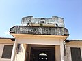 Ye Station
 -
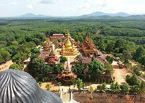
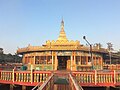 Sasana 2500 Pagoda
 -
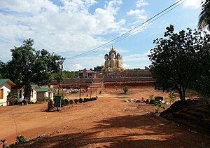
 Sakar Taung Pagoda


See also
References
- ^ "Myanmar: Regions, States, Major Cities & Towns - Population Statistics, Maps, Charts, Weather and Web Information". www.citypopulation.de. Retrieved 2021-04-01.
- ^ "Heavy flooding hits Ye; markets and schools closed". www.mizzima.com. Archived from the original on 2011-08-03.
- ^ "World Meteorological Organization Climate Normals for 1991–2020". World Meteorological Organization. Retrieved 16 October 2023.
- v
- t
- e
Capital: Mawlamyine


and villages
- Bilin
- Chaungzon
- Kamarwet
- Kyaikkhami
- Kyaikmaraw
- Kyaikto
- Mawlamyine
- Mudon
- Paung
- Zinkyaik
- Sittaung (historic site)
- Thanbyuzayat
- Thaton
- Thuwanawaddy
- Ye
- Khawzar


