District de Waidhofen an der Thaya

Cet article est une ébauche concernant l’Autriche.
Vous pouvez partager vos connaissances en l’améliorant (comment ?) selon les recommandations des projets correspondants.
| Waidhofen an der Thaya | |||
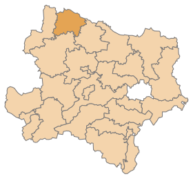 Localisation du district de Waidhofen an der Thaya dans le Land autrichien de Basse-Autriche. | |||
| Administration | |||
|---|---|---|---|
| Pays |  Autriche Autriche | ||
| Land |  Basse-Autriche Basse-Autriche | ||
| Centre administratif | Waidhofen an der Thaya | ||
| Immatriculation | WT | ||
| Démographie | |||
| Population | 25 888 hab. () | ||
| Densité | 39 hab./km2 | ||
| Géographie | |||
| Coordonnées | 48° 50′ 38″ nord, 15° 17′ 56″ est | ||
| Superficie | 66 914 ha = 669,14 km2 | ||
| Localisation | |||
| Géolocalisation sur la carte : Autriche
Géolocalisation sur la carte : Autriche
| |||
modifier  | |||


Le district de Waidhofen an der Thaya est une subdivision territoriale du Land de Basse-Autriche en Autriche.
Géographie
Lieux administratifs voisins
 | ||
Communes
Le district de Waidhofen an der Thaya est subdivisé en 15 communes :
Carte interactive des communes du district de Waidhofen an der Thaya

Les subdivisions administratives.
Notes et références
v · m Communes dans le district de Waidhofen an der Thaya | ||
|---|---|---|
 | ||
v · m | ||
|---|---|---|
| Les 21 districts (Bezirke) et les 4 villes à statut (Statutarstädte) de la Basse-Autriche, en Autriche | ||
| Villes à statut |  | |
| Districts |
| |
 Portail de l'Autriche


