Columbia Point, Boston

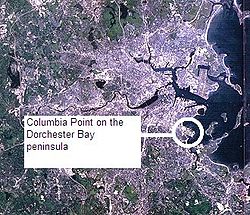
Columbia Point, di kawasan Dorchester, Boston, Massachusetts berada di sebuah semenanjung yang menjorok dari daratan utama timur Dorchester menghadap teluk. Old Harbor Park berada di sisi utara, berdekatan dengan Old Harbor, bagian dari Teluk Dorchester.
Referensi
Catatan
Daftar pustaka
- "Urban Transformations: Columbia Point - Harbor Point, Boston" Diarsipkan 2008-04-10 di Wayback Machine.
- Ball, Joanne, "Can Columbia Point Be Harbor Point? Conversion Represents A Test Of Social Engineering", The Boston Globe, August 14, 1988
- Bressi, Todd, "From the Outside Looking In: An Evaluation of Harbor Point", Places journal, v.8, no.4, Summer 1993, College of Environmental Design, UC Berkeley
- Diesenhouse, Susan, "Community Rises From Boston Slum", The New York Times, November 15, 1987
- Goody, Joan E., "From Project to Community: The Redesign of Columbia Point", Places journal, v.8, no.4, Summer 1993, College of Environmental Design, UC Berkeley
- Higgins, Richard, "As Columbia Point Is Reborn, Nuns Face Displacement Battle", The Boston Globe, July 23, 1988
- Kamin, Blair, "Rethinking Public Housing", Blueprints magazine, v.15, n.3, Summer 1997 issue, National Building Museum, Washington, D.C.
- Lawton, Heather Block, Research Materials for the book "A Decent Place to Live: from Columbia Point to Harbor Point", University of Massachusetts, Boston, September 2001. (archived 2006)
- Marwell, Stuart; Burke, Bryan; Hudak, Andrew, "Calf Pasture Pumping Station", Boston Public Library, BRA (Boston Redevelopment Authority) collection
- Millson, Rebecca Michelle; Spirn, Anne Whiston, MIT 4.211 course on "The Once and Future City", focusing on Harbor Point/Columbia Point, Spring 2007. (archived 2007)
- Pader, Ellen J; Breitbart, Myrna Margulies, "Transforming Public Housing: Conflicting Visions for Harbor Point", Places journal, v.8, no.4, Summer 1993, College of Environmental Design, UC Berkeley
- Roessner, Jane. "A Decent Place to Live: from Columbia Point to Harbor Point - A Community History", Boston: Northeastern University Press, c2000. ISBN 1-55553-437-6
- Excerpts from the book "A Decent Place to Live"
- Rybczynski, Witold, "Radical Revival: Harbor Point was failed public housing—until it was rebuilt as the nation's first mixed-income community. Twenty-five years later, what can we learn from this visionary project?", ARCHITECT: The Magazine of the American Institute of Architects, American Institute of Architects, August 16, 2013
- Silverstein, Nina M.; Conahan, Judith M., &al., "Aging in Place at Harbor Point: Outreach Follow-Up of Older Adults Living in Independent Mixed-Income Apartments", Gerontology Institute and College of Public and Community Service, University of Massachusetts Boston, November 2004
- Thebaud, Angie, et al., "Privately-Funded Public Housing Redevelopment: A Study of the Transformation of Columbia Point" Diarsipkan 2016-03-16 di Wayback Machine., Boston, Massachusetts, September 2008, Institute for International Urban Development
- Vale, Lawrence J., From the Puritans to the projects: public housing and public neighbors, Harvard University Press, 2000. Cf. especially p.255, 357-8, various on Columbia Point Housing Project history.
Pranala luar
Wikimedia Commons memiliki media mengenai Columbia Point, Boston.
- Map of Columbia Point - Boston Redevelopment Authority, City of Boston (archived 2012)
- "Columbia Point Master Plan"[pranala nonaktif permanen] - Boston Redevelopment Authority, City of Boston
- Urban Transformations: Columbia Point - Harbor Point, Boston Diarsipkan 2008-04-10 di Wayback Machine. - presentation slides, Professor David W. Manzo, Boston College
- 1899 Map of Dorchester, Massachusetts with the N.Y. N.H. & H. R.R. running on the Old Colony line Diarsipkan 2007-07-16 di Wayback Machine. - note Mt. Vernon Street and part of Columbia Point in the lower right hand corner
- Boston 1903 map - see the Calf Pasture on Columbia Point in the lower middle right hand side just above Savin Hill
Koordinat: 42°18′49.39″N 71°02′00.37″W / 42.3137194°N 71.0334361°W / 42.3137194; -71.0334361


