Normandy Hilir
Normandy Hilir Basse-Normandiecode: fr is deprecated (Prancis) Basse-Normaundiecode: nrf is deprecated (Norman) | |
|---|---|
 Bendera  [[Normandy Hilir|]] | |
 | |
| Negara | Prancis |
| Dibubarkan | 2016-01-01 |
| Prefecture | Caen |
| Department | 3
|
| Luas | |
| • Total | 17.589 km2 (6,791 sq mi) |
| Populasi (2007-01-01) | |
| • Total | 1.453.000 |
| Produk Region Bruto | |
| • Total | €42,004 miliar |
| • Per kapita | €28.600 |
| Kode ISO 3166 | FR-P |
| NUTS Region | FR2 |
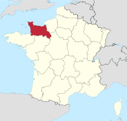
Normandy Hilir (bahasa Prancis: Basse-Normandie, IPA: [bɑs nɔʁmɑ̃di, bas -] (![]() simak); Norman: Basse-Normaundiecode: nrf is deprecated ) adalah bekas region administratif di Prancis. Pada 1 Januari 2016, Normandy Hilir dan Hulu bersatu menjadi satu region bernama Normandy.[2]
simak); Norman: Basse-Normaundiecode: nrf is deprecated ) adalah bekas region administratif di Prancis. Pada 1 Januari 2016, Normandy Hilir dan Hulu bersatu menjadi satu region bernama Normandy.[2]
Rujukan
 Portal Prancis

- Northcutt, Wayne; The Regions of France, A Reference Guide to History and Culture; 1996; Greenwood Press; ISBN 0-313-29223-X
- Some of the content of this article comes from the equivalent French-language Wikipedia article.
Pranala luar
Wikivoyage memiliki panduan wisata Lower Normandy.
- Normandy - Official French website (in English)
- Situs web resmi
- (dalam bahasa Inggris) Lower Normandy di Curlie (dari DMOZ)
Templat:Region di Prancis
Pengawasan otoritas | |
|---|---|
| Umum |
|
| Perpustakaan nasional |
|
| Lain-lain |
|
Koordinat: 49°00′N 1°00′W / 49.000°N 1.000°W / 49.000; -1.000


