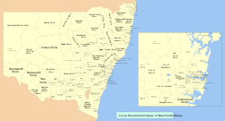
Wilayah pemerintahan daerah di New South Wales

Wilayah pemerintah daerah di New South Wales, Australia telah menjadi subyek periodik restrukturisasi dan rasionalisasi oleh Pemerintah Negara Bagian, melibatkan amalgamasi daerah secara sukarela maupun tak sukarela. Pemerintah negara bagian mengelompokkkan pemerintah lokal menjadi dua kategori: Kota dan Daerah, ada sedikit perbedaan di antara keduanya (sebuah Kota adalah sebuah Daerah yang menerima status kota dari Gubernur). Daerah umumnya menerima penetapan yang dipegang berdasarkan UU pra-reformasi, meskipun penetapan ini tidak lagi menandakan status hukum. Penetapan tersebut ialah:
- Municipality (terutama wilayah pinggiran kota terdalam dan kota pedesaan kecil)
- Shire (terutama wilayah pedesaan atau pinggiran terluar).
Sejumlah wilayah yang ditetapkan oleh Local Government Act 1993 telah mengadopsi jenis "Region", biasanya wilayah pedesaan besar yang didominasi oleh kota pedesaan. Banyak dewan sekarang yang memilih untuktidak menggunakan jenis daerah apapun, dan hanya menyebut mereka sebagai council, contohnya Booroowa Council, Burwood Council.
Per November 2005 terdapat 152 Local Government Area di New South Wales. Terdaftar di bawah dalam urutan abjad. Selain itu, juga ada Unincorporated Far West Region yang bukan bagian dari Local Government Area apapun, di daerah jarang penduduk seperti Far West, dan Lord Howe Island, yang juga tak berhubungan tetapi dipimpin sendiri oleh Lord Howe Island Board.
| Daftar isi: | Atas - 0–9 A B C D E F G H I J K L M N O P Q R S T U V W X Y Z - Pranala luar |
|---|
A
- Albury, City of
- Armidale Dumaresq Council
- Ashfield, Municipality of
- Auburn Council
B
- Ballina Shire Council
- Balranald Shire Council
- Bankstown, City of
- Bathurst Regional Council
- Bega Valley Shire
- Bellingen Shire Council
- Berrigan Shire Council
- Blacktown, City of
- Bland Shire Council
- Blayney Shire Council
- Blue Mountains, City of
- Bogan Shire Council
- Bombala Council
- Boorowa Council
- Botany Bay, City of
- Bourke Shire Council
- Brewarrina Shire Council
- Broken Hill, City of
- Burwood Council
- Byron Shire Council
C
- Cabonne Shire
- Camden Council
- Campbelltown, City of
- Canada Bay, City of
- Canterbury, City of
- Carrathool Shire Council
- Central Darling Shire Council
- Cessnock, City of
- Clarence Valley Council
- Cobar Shire Council
- Coffs Harbour, City of
- Conargo Shire Council
- Coolamon Shire Council
- Cooma-Monaro Shire Council
- Coonamble Shire Council
- Cootamundra Shire Council
- Corowa Shire Council
- Cowra Shire Council
D
- Deniliquin Council
- City of Dubbo
- Dungog Shire Council
E
- Eurobodalla Shire Council
F
- Fairfield, City of
- Forbes Shire Council
G
- Gilgandra Shire Council
- Glen Innes Severn Council
- Gloucester Shire Council
- Gosford, City of
- Goulburn Mulwaree Council
- Greater Hume Shire Council
- Greater Taree, City of
- Great Lakes Council
- Griffith, City of
- Gundagai Shire Council
- Gunnedah Shire Council
- Guyra Shire Council
- Gwydir Shire Council
H
- Harden Shire Council
- Hawkesbury, City of
- Hay Shire Council
- Holroyd, City of
- Hornsby Shire
- Hunter's Hill, Municipality of
- Hurstville, City of
I
- Inverell Shire Council
J
- Jerilderie Shire Council
- Junee Shire Council
K
- Kempsey Shire Council
- Kiama, Municipality of
- Kogarah, Municipality of
- Ku-ring-gai Council
- Kyogle Council
L
- Lachlan Shire Council
- Lake Macquarie, City of
- Lane Cove, Municipality of
- Leeton Shire Council
- Leichhardt, Municipality of
- Lismore, City of
- Lithgow, City of
- Liverpool, City of
- Liverpool Plains Shire Council
- Lockhart Shire Council
M
- Maitland, City of
- Manly Council
- Marrickville Council
- Mid-Western Regional Council
- Moree Plains Shire Council
- Mosman, Municipality of
- Murray Shire Council
- Murrumbidgee Shire Council
- Muswellbrook Shire Council
N
- Nambucca Shire Council
- Narrabri Shire Council
- Narrandera Shire Council
- Narromine Shire Council
- Newcastle, City of
- North Sydney Council
O
- Oberon Council
- Orange, City of
P
- Palerang Council
- Parkes Shire Council
- Parramatta, City of
- Penrith, City of
- Pittwater Council
- Port Macquarie-Hastings Council
- Port Stephens Council
Q
- Queanbeyan, City of
R
- Randwick, City of
- Richmond Valley Council
- Rockdale, City of
- Ryde, City of
S
- Shellharbour, City of
- Shoalhaven, City of
- Singleton Shire Council
- Snowy River Shire Council
- Strathfield, Municipality of
- Sutherland Shire
- Sydney, City of
T
- Tamworth Regional Council
- Temora Shire Council
- Tenterfield Shire Council
- The Hills Shire
- Tumbarumba Shire Council
- Tumut Shire Council
- Tweed Shire Council
U
- Upper Hunter Shire Council
- Upper Lachlan Shire Council
- Uralla Shire Council
- Urana Shire Council
W
- Wagga Wagga, City of
- Wakool, Council of the Shire of
- Walcha Council
- Walgett Shire Council
- Warren Shire, New South Wales
- Warringah Council
- Warrumbungle Shire Council
- Waverley Council
- Weddin Shire Council
- Wellington Council
- Wentworth Shire Council
- Willoughby, City of
- Wingecarribee Shire Council
- Wollondilly Shire Council
- Wollongong, City of
- Woollahra, Municipality of
- Wyong Shire
Y
- Yass Valley Council
- Young Shire Council
Z
Pranala luar
- Map of Local Government Areas in New South Wales PDF Diarsipkan 2014-06-22 di Wayback Machine., showing recent council amalgamations
- Clickable map of New South Wales LGAs Diarsipkan 2001-08-09 di Wayback Machine. (New South Wales Department of Local Government)
- Shires of Australia di statoids.com


