トンサ県
座標: 北緯27度20分 東経90度25分 / 北緯27.333度 東経90.417度 / 27.333; 90.417


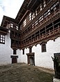
トンサ県(トンサけん、ゾンカ語:ཀྲོང་གསར་རྫོང་ཁག་/ワイリー方式:Krong-gsar rdzong-khag)は、ブータン南部の県。ブータンの地理的中心はトンサ城(英語版)にある。
言語
中南部のオレ語話者は消滅した。 [1] 歴史的に、ブータン中部〜東部に広がるブムタン語話者は、クルトプ語やマンドゥエピカ語、ケン語話者との繋がりが強い。 これらはまとめて「ブムタン諸語」とも呼ばれる [2] [3] [4]。
地理
トンサ県は西にワンデュ・ポダン県、東にブムタン県、南にチラン県・サルパン県・シェムガン県に接する。
行政区画
トンサ県は5つの村に分かれる [5]。
- ドラグテン村(英語版)
- コルフ村(英語版)
- ランシル村(英語版)
- ヌビ村(英語版)
- タンシブジ村(英語版)
環境
トンサ県の殆どは環境保護区である。 北部(ヌビ村)にはワンチュク百年国立公園(英語版)が、中央部〜西部〜南部(ランシル村、タングシブジ村)にはジグミ・シンゲ・ワンチュク国立公園(英語版)が有り、緑の回廊で繋がっている。 南東部から北東部にはスルムシン峠国立公園(英語版)に繋がる緑の回廊が広がっている[5][6]。
関連項目
- トンサ州(英語版)
- トンサ県
-

-
-

-

-
-


脚注
- ^ van Driem, George L. (1993年). “Language Policy in Bhutan” (PDF). London: SOAS. 2011年1月18日閲覧。
- ^ Schicklgruber, Christian (1998). Françoise Pommaret-Imaeda. ed. Bhutan: Mountain Fortress of the Gods. Shambhala. pp. 50, 53. https://books.google.co.jp/books?id=8Q1uAAAAMAAJ&redir_esc=y&hl=ja
- ^ van Driem, George (2007). “Endangered Languages of Bhutan and Sikkim: East Bodish Languages”. In Moseley, Christopher. Encyclopedia of the World's Endangered Languages. Routledge. p. 295. ISBN 0-7007-1197-X. https://books.google.co.jp/books?id=6LoNl7ZRO70C&redir_esc=y&hl=ja
- ^ van Driem, George (2007). Matthias Brenzinger. ed. Language diversity endangered. Trends in linguistics: Studies and monographs, Mouton Reader. 181. Walter de Gruyter. p. 312. ISBN 3-11-017050-7. https://books.google.co.jp/books?id=6p6b5GQ4Q4YC&redir_esc=y&hl=ja
- ^ a b “Chiwogs in Trongsa” (PDF). Election Commission, Government of Bhutan (2011年). 2011年7月28日閲覧。
- ^ “Parks of Bhutan”. Bhutan Trust Fund for Environmental Conservation online. Bhutan Trust Fund. 2011年7月2日時点のオリジナルよりアーカイブ。2011年3月26日閲覧。
| ||
|---|---|---|
| 中部 |  | |
| 南部 | ||
| 西部 | ||
| 東部 |
| |
| 典拠管理データベース: 国立図書館 |
|
|---|


 トンサ県
トンサ県