Brent (Londen)
Borough van Londen  | |||
|---|---|---|---|
 | |||
 | |||
| Situering | |||
| Land | Engeland | ||
| County | Outer London | ||
| Regio | London | ||
| Coördinaten | 51°33'32"NB, 0°16'52"WL | ||
| Algemeen | |||
| Oppervlakte | 43,2325[1] km² | ||
| Inwoners (2018[2]) | 330795 (7652 inw./km²) | ||
| ONS-code | E09000005 | ||
| |||

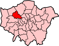
Brent (London Borough of Brent) is een Engels district of borough in de regio Groot-Londen, gelegen in het noordwesten van de metropool. De borough telt 329.104 inwoners en heeft een oppervlakte van 43 km². Van de bevolking is 11,5% ouder dan 65 jaar. De werkloosheid bedraagt 5,0% van de beroepsbevolking (cijfers volkstelling 2001).
Wijken in Brent
- Alperton
- Brent Park
- Brondesbury
- Brondesbury Park
- Cricklewood
- Dollis Hill
- Harlesden
- Kensal Green
- Kilburn
- Kingsbury
- Neasden
- North Wembley
- Northwick Park
- Park Royal
- Preston
- Queensbury
- Queen's Park
- South Kenton
- Stonebridge
- Sudbury
- Tokyngton
- Wembley
- Wembley Park
- Willesden
- Willesden Green
Geboren
- Kaylen Hinds (1998), voetballer
Bronnen, noten en/of referenties
|
Mediabestanden
Zie de categorie Brent van Wikimedia Commons voor mediabestanden over dit onderwerp.


