Greenville County
County in de Verenigde Staten  | |||
|---|---|---|---|
 | |||
| Situering | |||
| Staat | South Carolina | ||
| Coördinaten | 34°53'24"NB, 82°22'12"WL | ||
| Algemeen | |||
| Oppervlakte | 2.059 km² | ||
| - land | 2.046 km² | ||
| - water | 13 km² | ||
| Inwoners (2000) | 379.616 (186 inw./km²) | ||
| Overig | |||
| Zetel | Greenville | ||
| FIPS-code | 45045 | ||
| Opgericht | 1798 | ||
| Foto's | |||
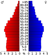 Bevolkingspiramide Greenville County | |||
| Statistieken volkstelling Greenville County | |||
| |||

Greenville County is een van de 46 county's in de Amerikaanse staat South Carolina.
De county heeft een landoppervlakte van 2.046 km² en telt 379.616 inwoners (volkstelling 2000). De hoofdplaats is Greenville.
In de county ligt onder meer de berg Glassy Mountain.
Bevolkingsontwikkeling
| Historische inwonertallen | |||
|---|---|---|---|
| Jaar | Inwoners | % ± | |
| 1900 | 53.490 | — | |
| 1910 | 68.377 | 27,8% | |
| 1920 | 88.498 | 29,4% | |
| 1930 | 117.009 | 32,2% | |
| 1940 | 136.580 | 16,7% | |
| 1950 | 168.152 | 23,1% | |
| 1960 | 209.776 | 24,8% | |
| 1970 | 240.546 | 14,7% | |
| 1980 | 287.913 | 19,7% | |
| 1990 | 320.167 | 11,2% | |
| 2000 | 379.616 | 18,6% | |
| Bron: (en) Historical Decennial Census Population | |||
· Abbeville County · Aiken County · Allendale County · Anderson County · Bamberg County · Barnwell County · Beaufort County · Berkeley County · Calhoun County · Charleston County · Cherokee County · Chester County · Chesterfield County · Clarendon County · Colleton County · Darlington County · Dillon County · Dorchester County · Edgefield County · Fairfield County · Florence County · Georgetown County · Greenville County · Greenwood County · Hampton County · Horry County · Jasper County · Kershaw County · Lancaster County · Laurens County · Lee County · Lexington County · Marion County · Marlboro County · McCormick County · Newberry County · Oconee County · Orangeburg County · Pickens County · Richland County · Saluda County · Spartanburg County · Sumter County · Union County · Williamsburg County · York County


