McKean County
County in de Verenigde Staten  | |||
|---|---|---|---|
 | |||
| Situering | |||
| Staat | Pennsylvania | ||
| Tijdzone | Eastern Standard Time (UTC−5) | ||
| Coördinaten | 41°48'40"NB, 78°26'41"WL | ||
| Algemeen | |||
| Oppervlakte | 2.549 km² | ||
| - land | 2.542 km² | ||
| - water | 7 km² | ||
| Inwoners (2000) | 45.936 (18 inw./km²) | ||
| Overig | |||
| Zetel | Smethport | ||
| FIPS-code | 42083 | ||
| Opgericht | 1804 | ||
| Detailkaart | |||
 | |||
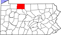
| Overzichtskaart van McKean County | |||
| Foto's | |||
 Bevolkingspiramide McKean County | |||
| Statistieken volkstelling McKean County | |||
| |||

McKean County is een van de 67 county's in de Amerikaanse staat Pennsylvania.
De county heeft een landoppervlakte van 2.542 km² en telt 45.936 inwoners (volkstelling 2000). De hoofdplaats is Smethport.

Adams County · Allegheny County · Armstrong County · Beaver County · Bedford County · Berks County · Blair County · Bradford County · Bucks County · Butler County · Cambria County · Cameron County · Carbon County · Centre County · Chester County · Clarion County · Clearfield County · Clinton County · Columbia County · Crawford County · Cumberland County · Dauphin County · Delaware County · Elk County · Erie County · Fayette County · Forest County · Franklin County · Fulton County · Greene County · Huntingdon County · Indiana County · Jefferson County · Juniata County · Lackawanna County · Lancaster County · Lawrence County · Lebanon County · Lehigh County · Luzerne County · Lycoming County · McKean County · Mercer County · Mifflin County · Monroe County · Montgomery County · Montour County · Northampton County · Northumberland County · Perry County · Philadelphia County · Pike County · Potter County · Schuylkill County · Snyder County · Somerset County · Sullivan County · Susquehanna County · Tioga County · Union County · Venango County · Warren County · Washington County · Wayne County · Westmoreland County · Wyoming County · York County


