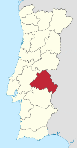
Portalegre (district)
District in Portugal  | |||
|---|---|---|---|
 | |||
| Coördinaten | 39°17'28"NB, 7°25'55"WL | ||
| Algemeen | |||
| Oppervlakte | 6065 km² | ||
| Inwoners (2001) | 127.018 (20,9 inw./km²) | ||
| Hoofdstad | Portalegre | ||
| |||

District Portalegre is een district van Portugal, met een oppervlakte van 6065 km² het zesde grootste district. Het inwonersaantal is 127 018 (2001). Hoofdstad is de gelijknamige stad Portalegre.
Het district is onderverdeeld in 15 gemeenten:
- Alter do Chão
- Arronches
- Avis
- Campo Maior
- Castelo de Vide
- Crato
- Elvas
- Fronteira
- Gavião
- Marvão
- Monforte
- Nisa
- Ponte de Sor
- Portalegre
- Sousel

Bestuurlijke indeling van Portugal: districten (distritos)
Aveiro · Beja · Braga · Bragança · Castelo Branco · Coimbra · Évora · Faro · Guarda · Leiria · Lissabon · Portalegre · Porto · Santarém · Setúbal · Viana do Castelo · Vila Real · Viseu
Autonome regio's van Portugal: Azoren · Madeira


