Tandragee
Plaats in Noord-Ierland  | |||
|---|---|---|---|
  | |||
| Situering | |||
| Graafschap | County Armagh | ||
| District | Armagh | ||
| Coördinaten | 54° 21′ NB, 6° 25′ WL | ||
| Algemeen | |||
| Oppervlakte | 12,3171[1] km² | ||
| Inwoners (2001) | 3018 (245 inw./km²) | ||
| Overig | |||
| Postcode | BT62 | ||
| Netnummer | 028, +44 28 | ||
| ONS-code | N08000238 | ||
| |||

Tandragee (Iers: Tóin re Gaoith) is een plaats in het Noord-Ierse district Armagh. Tandragee telt 3018 inwoners. Van de bevolking is 86,9% protestant en 10,5% katholiek.
Afbeeldingen
-
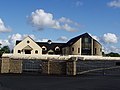 Nieuw kerkgebouw Free Presbyterian Church of Ulster
 -
 Interieur Free Presbyterian church


Bronnen, noten en/of referenties
- ↑ Office for National Statistics (ONS) → Download → SAM_for_Administrative_Areas_(2017).zip → SAM_WD_DEC_2017_UK.xlsx → kolom G. Gearchiveerd op 9 mei 2019.


