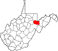
Tucker County
County in de Verenigde Staten  | |||
|---|---|---|---|
 | |||
| Situering | |||
| Staat | West Virginia | ||
| Tijdzone | Eastern Standard Time (UTC−5) | ||
| Coördinaten | 39°6'0"NB, 79°34'12"WL | ||
| Algemeen | |||
| Oppervlakte | 1.091 km² | ||
| - land | 1.085 km² | ||
| - water | 6 km² | ||
| Inwoners (2000) | 7.321 (7 inw./km²) | ||
| Overig | |||
| Zetel | Parsons | ||
| FIPS-code | 54093 | ||
| Opgericht | 1856 | ||
| Foto's | |||
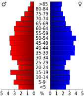 Bevolkingspiramide Tucker County | |||
| Statistieken volkstelling Tucker County | |||
| |||

Tucker County is een van de 55 county's in de Amerikaanse staat West Virginia.
De county heeft een landoppervlakte van 1.085 km² en telt 7.321 inwoners (volkstelling 2000). De hoofdplaats is Parsons.
Bevolkingsontwikkeling
| Historische inwonertallen | |||
|---|---|---|---|
| Jaar | Inwoners | % ± | |
| 1900 | 13.433 | ||
| 1910 | 18.675 | 39,0% | |
| 1920 | 16.791 | −10,1% | |
| 1930 | 13.374 | −20,4% | |
| 1940 | 13.173 | −1,5% | |
| 1950 | 10.600 | −19,5% | |
| 1960 | 7.750 | −26,9% | |
| 1970 | 7.447 | −3,9% | |
| 1980 | 8.675 | 16,5% | |
| 1990 | 7.728 | −10,9% | |
| 2000 | 7.321 | −5,3% | |
| Bron: (en) Historical Decennial Census Population | |||

Barbour County · Berkeley County · Boone County · Braxton County · Brooke County · Cabell County · Calhoun County · Clay County · Doddridge County · Fayatte County · Gilmer County · Grant County · Greenbrier County · Hampshire County · Hancock County · Hardy County · Harrison County · Jackson County · Jefferson County · Kanawha County · Lewis County · Lincoln County · Logan County · Marion County · Marshall County · Mason County · McDowell County · Mercer County · Mineral County · Mingo County · Monongalia County · Monroe County · Morgan County · Nicholas County · Ohio County · Pendleton County · Pleasants County · Pocahontas County · Preston County · Putnam County · Raleigh County · Randolph County · Ritchie County · Roane County · Summers County · Taylor County · Tucker County · Tyler County · Upshur County · Wayne County · Webster County · Wetzel County · Wirt County · Wood County · Wyoming County


