Waverley (Surrey)
Niet-metropolitaans district in Engeland  | |||
|---|---|---|---|
 | |||
| Situering | |||
| Land | Engeland | ||
| County | Surrey | ||
| Regio | South East England | ||
| Coördinaten | 51°11'3"NB, 0°37'3"WL | ||
| Algemeen | |||
| Oppervlakte | 345,1703[1] km² | ||
| Inwoners (2018[2]) | 125610 (364 inw./km²) | ||
| ONS-code | E07000216 | ||
| Detailkaart | |||
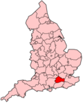
[[Bestand: |266px|class=notpageimage|alt=Kaart van Waverley]] |266px|class=notpageimage|alt=Kaart van Waverley]] | |||
| |||

Waverley is een Engels district met de status van borough in het shire-graafschap (non-metropolitan county OF county) Surrey en telt 126.000 inwoners. De oppervlakte bedraagt 345 km².
Van de bevolking is 17,6% ouder dan 65 jaar. De werkloosheid bedraagt 1,6% van de beroepsbevolking (cijfers volkstelling 2001).
Plaatsen in district Waverley
- Hindhead
- Milford
Civil parishes in district Waverley
Alfold, Bramley, Busbridge, Chiddingfold, Churt, Cranleigh, Dockenfield, Dunsfold, Elstead, Ewhurst, Farnham, Frensham, Godalming, Hambledon, Hascombe, Haslemere, Peper Harow, Thursley, Tilford, Witley, Wonersh.
Bronnen, noten en/of referenties
|


