Bromfield

För Bromfield i Shropshire, se Bromfield, Shropshire.
Bromfield
Bromfield
Bromfield
Land Storbritannien Storbritannien
Riksdel England
Grevskap Cumbria
Distrikt Allerdale
Koordinater 54°48′36″N 3°17′06″V / 54.81°N 3.285°V / 54.81; -3.285
Tidszon GMT (UTC+0)
Riktnummer 01697
Geonames 7300105
2654590

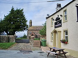
Bromfield är en by och en civil parish i Allerdale i Cumbria i England. Orten har 530 invånare (2001).[1] Den har en kyrka.[2][3]

Referenser

  1. ^ Neighbourhood statistics Arkiverad 17 december 2014 hämtat från the Wayback Machine.
  2. ^ http://www.britishlistedbuildings.co.uk/en-410437-church-of-st-mungo-bromfield
  3. ^ http://www.visitcumbria.com/churches/bromfield-st-mungos-church.htm

Externa länkar

  • http://www.britishlistedbuildings.co.uk/england/cumbria/bromfield
v  r
Allerdale
Civil parishes
Above Derwent · Aikton · Allhallows · Allonby · Aspatria · Bassenthwaite · Bewaldeth and Snittlegarth · Blennerhasset and Torpenhow · Blindbothel · Blindcrake · Boltons · Borrowdale · Bothel and Threapland · Bowness · Bridekirk · Brigham · Bromfield · Broughton · Broughton Moor · Buttermere · Caldbeck · Camerton · Cockermouth · Crosscanonby · Dean · Dearham · Dundraw · Embleton · Gilcrux · Great Clifton · Greysouthen · Hayton and Mealo · Holme Abbey · Holme East Waver · Holme Low · Holme St Cuthbert · Ireby and Uldale · Keswick · Kirkbampton · Kirkbride · Lands common to Holme Abbey, Holme Low and Holme St Cuthbert · Little Clifton · Lorton · Loweswater · Maryport · Oughterside and Allerby · Papcastle · Plumbland · Seaton · Sebergham · Setmurthy · Silloth-on-Solway · St. John's Castlerigg and Wythburn · Thursby · Underskiddaw · Waverton · Westnewton · Westward · Wigton · Winscales · Woodside · Workington · Wythop