Ardmore, County Londonderry
Village in County Londonderry, Northern Ireland
Village and townland in Northern Ireland, United Kingdom
Ardmore Irish: An tArd Mór[1] | |
|---|---|
village and townland | |
| Irish transcription(s) | |
| • Derivation: | Ard Mór |
| • Meaning: | Great height |
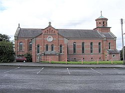 Ardmore Roman Catholic Church in 2006 | |
| 54°57′22″N 7°16′44″W / 54.956°N 7.279°W / 54.956; -7.279 | |
| Sovereign state | United Kingdom |
| Country | Northern Ireland |
| County | Londonderry |
| Barony | Tirkeeran |
| Civil parish | Clondermot |
| Settlements | Ardmore |
| Area [2] | |
| • Total | 504.38 acres (204.11 ha) |
Ardmore (from Irish An tArd Mór, meaning 'the great height')[1][3] is a village and townland in County Londonderry, Northern Ireland. In the 2001 Census it had a population of 210. It is within Derry and Strabane district. Ardmore has a number of sports teams including cricket, soccer and Gaelic football.
Sport
- Ardmore Cricket Club
Railways
The Londonderry and Coleraine Railway opened the Ardmore railway station on 4 July 1883.[4]
It closed on 1 January 1933.
Wikimedia Commons has media related to Ardmore, County Londonderry.
References
- ^ a b [1] Placenames Database of Ireland
- ^ Northern Ireland Environment Agency. "NIEA Map Viewer". Archived from the original on 24 November 2011. Retrieved 27 January 2012.
- ^ Placenames NI Archived July 27, 2011, at the Wayback Machine
- ^ "Ardmore station" (PDF). Railscot - Irish Railways. Retrieved 29 April 2012.
- NI Neighbourhood Information System
- Lewis, 1837
- v
- t
- e
Places in County Londonderry

and townlands
- Aghadowey
- Altnagelvin
- Ardgarvan
- Ardmore
- Articlave
- Artikelly
- Ballerin
- Ballyhanedin
- Ballykelly
- Ballylifford
- Ballymaguigan
- Ballynagalliagh
- Ballyrashane
- Ballyronan
- Ballyrory
- Ballyscullion
- Banagher
- Bellaghy
- Bellarena
- Benone
- Bogside
- Broighter
- Burnfoot
- Campsey
- Carrowclare
- Castledawson
- Castlerock
- Clady
- Claudy
- Coagh
- Culmore
- Culnady
- Curran
- Derrynaflaw
- Desertmartin
- Downhill
- Draperstown
- Drumahoe
- Drummullan
- Drumraighland
- Drumsurn
- Eglinton
- Elagh More
- Feeny
- Foreglen
- Garvagh
- Glack
- Glenone
- Gortnahey
- Goshedan
- Greysteel
- Gulladuff
- Inishrush
- Kilcronaghan
- Killaloo
- Killywool
- Kilrea
- Knockloughrim
- Largy
- Lavey
- Lenamore
- Lettershandoney
- Lisbunny
- Lissan
- Macosquin
- Maghera
- Magilligan
- Maydown
- Moneymore
- Moneyneany
- Newbuildings
- Nixon's Corner
- Park
- Prehen
- Ringsend
- Shantallow
- Shanvey
- Straidarran
- Strathfoyle
- Straw
- Swatragh
- Tamlaght
- Tamnaherin
- The Loup
- Tobermore
- Upperlands
- WikiProject Northern Ireland
- WikiProject Ireland
- Northern Ireland Portal
- United Kingdom Portal
- Ireland Portal
 | This article related to the geography of County Londonderry, Northern Ireland is a stub. You can help Wikipedia by expanding it. |
- v
- t
- e


