Bald Rock National Park
Protected area in New South Wales, Australia
28°51′9″S 152°03′20″E / 28.85250°S 152.05556°E / -28.85250; 152.05556New South Wales
Bald Rock National Park is a national park in northern New South Wales, Australia, just north of Tenterfield on the Queensland border. The border passes over the rock on the Western side. On the other side of the border national park continues as the Girraween National Park.

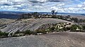
The park is named after its most prominent feature, Bald Rock, which is a large granite outcrop rising 260 metres above the surrounding landscape and almost 1300 metres above sea level.[2] Measuring about 750 metres long and 500 metres wide this is the largest granite monolith in Australia.[3][4] Access to the rock is provided by a sealed road into the park and walking tracks to the summit. Two tracks are marked, a steep one up the exposed face, or an easier gradient through bushland around the back. The Bungoona Walking Track, built in 1980, goes more gently up the eastern side of Bald Rock and winds through forest. It passes through some granite boulder formations, including an arch, covered in mosses, ferns and orchids. The summit offers panoramic views of the surrounding bushland, but vegetation on top prevents a full 360° view. The views are so expansive, mountains as far north as the Queensland/New South Wales border can be seen, such as Mount Barney, Mount Lindesay and Flinders Peak, and as far south as Mount MacKenzie, south of Tenterfield.
The park is in the New England granite belt, where about 220 million years ago an episode of granite magmatism resulted in the intrusion of the Stanthorpe Adamellite into the surrounding metamorphic and sedimentary rock. Subsequent uplift and erosion of the New England Fold Belt has seen the majority of the surrounding sediments and metamorphic rocks eroded away, with the Stanthorpe Adamellite remaining due to its resistance to weathering.
For many millennia, Bald Rock functioned as a neutral territory where the three indigenous nations of the area – the Jukembal, Bundjalung, and Kamilaroi – found common ground. Serving as a natural boundary, the rock allowed for gatherings and trade between these nations, eliminating the need for them to traverse each other's lands.[2]
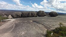
This regolith has created a landscape with many exposed inselbergs of granite rocks, some balancing on top of each other, or forming natural arches.

In 2019/2020, bushfires severely damaged the Bungoona walking track. The NSW Government invested $800,000 repairing and upgrading the track, including making it wheelchair-accessible. The upgrades were completed in March 2023.[4]
Just off the main road from Tenterfield to the park is Thunderbolt's Hideout, a set of caves and overhanging granite rocks. It was thought to have been used by bushranger Captain Thunderbolt. A little further along the same road are some historic World War II tank traps.
Gallery
-
 Western View from Bald Rock
 -
 Northern View from Bald Rock
 -
 Eastern View from Bald Rock
 -
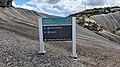
 Sign for walking paths and summit
 -
 Sign for balancing rocks and summit
 -
 Bald Rock Trig station and Stone Pillar
 -
 Metal plate with directional lines pointing to distant landmarks and views


See also
- Protected areas of New South Wales
- High Conservation Value Old Growth forest
- Captain Thunderbolt's Rock
- Bald Rock National Park at the NSW National Parks and Wildlife Service
- Captain Thunderbolts Hideout at NSW Schools Country Area Program
References
- ^ "Department of Environment Climate Change and Water Annual Report 2009-10". Annual Report. Department of Environment Climate Change and Water: 274–275. November 2010. ISSN 1838-5958.
- ^ a b "Bald Rock national Park". Visit Tenterfield. Archived from the original on 9 March 2023. Retrieved 13 August 2023.
- ^ Reader's Digest Guide to Australian Places. Sydney: Reader's Digest.
- ^ a b "$800,000 accessibility upgrade at Bald Rock National Park complete". NSW Government. Archived from the original on 1 April 2023. Retrieved 8 June 2023.
- v
- t
- e
- Abercrombie
- Breelong
- Capertee
- Conimbla
- Coolah Tops
- Drillwarrina
- Gardens of Stone
- Garrawilla
- Goobang
- Goulburn
- Kanangra-Boyd
- Lachlan Valley
- Marrangaroo
- Nangar
- Popran
- Turon
- Warrumbungle
- Weddin Mountains
- Wollemi
- Brindingabba
- Culgoa
- Gundabooka
- Kalyarr
- Kemendok
- Kinchega
- Koonaburra
- Mallee Cliffs
- Mungo
- Mutawintji
- Narriearra Caryapundy Swamp
- Paroo-Darling
- Sturt
- Toorale
- Yanga
- Barakee
- Barrington Tops
- Belford
- Ben Halls Gap
- Biriwal Bulga
- Booti Booti
- Bouddi
- Brisbane Water
- Coolah Tops
- Coorabakh
- Crawney Pass
- Crowdy Bay
- Dharug
- Gir-um-bit
- Goulburn River
- Gin-Doo-Ee
- Hunter Wetlands
- Karuah
- Middle Brother
- Mount Royal
- Myall Lakes
- Saltwater
- Scone Mountain
- Tapin Tops
- Tilligerry
- Towarri
- Tomaree
- Wallarah
- Wallingat
- Watagans
- Werakata
- Woko
- Wollemi
- Wyrrabalong
- Yengo
- Bald Rock
- Barool
- Basket Swamp
- Boonoo Boonoo
- Ben Halls Gap
- Burral Yurrul
- Butterleaf
- Capoompeta
- Carrai
- Cascade
- Cataract
- Cathedral Rock
- Coolah Tops
- Cottan-Bimbang
- Couradda
- Crawney Pass
- Cunnawarra
- Dowe
- Gibraltar Range
- Guy Fawkes River
- Indwarra
- Kings Plain
- Koreelah
- Kwiambal
- Maryland
- Mount Clunie
- Mount Kaputar
- Mount Nothofagus
- Mummel Gulf
- New England
- Nowendoc
- Nullamanna
- Nymboida
- Oxley Wild Rivers
- Single
- Timbarra
- Tooloom
- Towarri
- Warra
- Warrabah
- Washpool
- Watsons Creek
- Werrikimbe
- Arakwal
- Bago Bluff
- Bellinger River
- Bindarri
- Biriwal Bulga
- Bongil Bongil
- Border Ranges
- Broadwater
- Bundjalung
- Bungawalbin
- Carrai
- Chaelundi
- Cottan-Bimbang
- Crowdy Bay
- Dooragan
- Dorrigo
- Dunggir
- Fortis Creek
- Gibraltar Range
- Goonengerry
- Guy Fawkes River
- Hat Head
- Junuy Juluum
- Kumbatine
- Limeburners Creek
- Mallanganee
- Maria
- Mebbin
- Middle Brother
- Mooball
- Mount Jerusalem
- Mount Nothofagus
- Mount Pikapene
- New England
- Nightcap
- Nymboi-Binderay
- Nymboida
- Ramornie
- Richmond Range
- Sea Acres
- Toonumber
- Ulidarra
- Washpool
- Werrikimbe
- Willi Willi
- Wollumbin
- Yabbra
- Yarrahapinni Wetlands
- Yarriabini
- Yuraygir
- Benambra
- Brindabella
- Cocoparra
- Jimberoo
- Jindalee
- Kalyarr
- Kosciuszko
- Lachlan Valley
- Livingstone
- Minjary
- Murray Valley
- Murrumbidgee Valley
- Oolambeyan
- Willandra
- Woomargama
- Yanga
- Abercrombie
- Bangadilly
- Beowa
- Biamanga
- Blue Mountains
- Bournda
- Brindabella
- Budawang
- Budderoo
- Clyde River
- Deua
- Eurobodalla
- Gourock
- Gulaga
- Kooraban
- Kosciuszko
- Mares Forest
- Macquarie Pass
- Mimosa Rocks
- Monga
- Morton
- Mount Imlay
- Murramarang
- Nattai
- South East Forests
- Tallaganda
- Tarlo River
- Wadbilliga
- Yanununbeyan
Authority control databases | |
|---|---|
| International |
|
| National |
|


