Beloozyorsky
Town in Moscow Oblast, Russia
You can help expand this article with text translated from the corresponding article in Russian. (March 2024) Click [show] for important translation instructions.
- Machine translation, like DeepL or Google Translate, is a useful starting point for translations, but translators must revise errors as necessary and confirm that the translation is accurate, rather than simply copy-pasting machine-translated text into the English Wikipedia.
- Do not translate text that appears unreliable or low-quality. If possible, verify the text with references provided in the foreign-language article.
- You must provide copyright attribution in the edit summary accompanying your translation by providing an interlanguage link to the source of your translation. A model attribution edit summary is
Content in this edit is translated from the existing Russian Wikipedia article at [[:ru:Белоозёрский]]; see its history for attribution. - You may also add the template
{{Translated|ru|Белоозёрский}}to the talk page. - For more guidance, see Wikipedia:Translation.
Town in Moscow Oblast, Russia
Beloozyorsky Белоозёрский | |
|---|---|
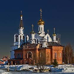 Church of All Saints in Beloozyorsky | |
 Flag  Coat of arms | |
Location of Beloozyorsky  | |
55°27′32″N 38°26′28″E / 55.4589°N 38.4411°E / 55.4589; 38.4411 | |
| Country | Russia |
| Federal subject | Moscow Oblast |
| Administrative district | Voskresensky District |
| Founded | 1961 |
| Town status since | 2019 |
| Population (2010 Census)[1] | |
| • Total | 17,842 |
| • Estimate (2018)[2] | 18,297 (+2.6%) |
| Time zone | UTC+3 (MSK |
| Postal code(s)[4] | 140250 |
| Dialing code(s) | +7 49644 |
| OKTMO ID | 46606154051 |
| Website | beloozerskiy |
Beloozyorsky (Russian: Белоозёрский) is an urban locality (a town) in Voskresensky District of Moscow Oblast, Russia. Population: 13,737 (2021 Census);[5] 17,842 (2010 Russian census);[1] 14,494 (2002 Census);[6] 11,866 (1989 Soviet census).[7]
Beloozyorsky lies on the left bank of the Moscow River 20 km northwest of district's administrative center, Voskresensk. It gained town status on 5 April 2019,[8] being an urban-type settlement before that date. Beloozyorsky is connected with Moscow by the Ryazansky suburban railway line.
References
- ^ a b Russian Federal State Statistics Service (2011). Всероссийская перепись населения 2010 года. Том 1 [2010 All-Russian Population Census, vol. 1]. Всероссийская перепись населения 2010 года [2010 All-Russia Population Census] (in Russian). Federal State Statistics Service.
- ^ "26. Численность постоянного населения Российской Федерации по муниципальным образованиям на 1 января 2018 года". Federal State Statistics Service. Retrieved January 23, 2019.
- ^ "Об исчислении времени". Официальный интернет-портал правовой информации (in Russian). June 3, 2011. Retrieved January 19, 2019.
- ^ Почта России. Информационно-вычислительный центр ОАСУ РПО. (Russian Post). Поиск объектов почтовой связи (Postal Objects Search) (in Russian)
- ^ Russian Federal State Statistics Service. Всероссийская перепись населения 2020 года. Том 1 [2020 All-Russian Population Census, vol. 1] (XLS) (in Russian). Federal State Statistics Service.
- ^ Federal State Statistics Service (May 21, 2004). Численность населения России, субъектов Российской Федерации в составе федеральных округов, районов, городских поселений, сельских населённых пунктов – районных центров и сельских населённых пунктов с населением 3 тысячи и более человек [Population of Russia, Its Federal Districts, Federal Subjects, Districts, Urban Localities, Rural Localities—Administrative Centers, and Rural Localities with Population of Over 3,000] (XLS). Всероссийская перепись населения 2002 года [All-Russia Population Census of 2002] (in Russian).
- ^ Всесоюзная перепись населения 1989 г. Численность наличного населения союзных и автономных республик, автономных областей и округов, краёв, областей, районов, городских поселений и сёл-райцентров [All Union Population Census of 1989: Present Population of Union and Autonomous Republics, Autonomous Oblasts and Okrugs, Krais, Oblasts, Districts, Urban Settlements, and Villages Serving as District Administrative Centers]. Всесоюзная перепись населения 1989 года [All-Union Population Census of 1989] (in Russian). Институт демографии Национального исследовательского университета: Высшая школа экономики [Institute of Demography at the National Research University: Higher School of Economics]. 1989 – via Demoscope Weekly.
- ^ "Постановление Губернатора Московской области от 05.04.2019 № 146-ПГ" [Decree of the Governor of Moscow Oblast of 5 April 2019 No. 146-PG]. Government of Moscow Oblast (in Russian). Archived from the original on April 30, 2019. Retrieved March 15, 2022.
- v
- t
- e
- Chekhovsky
- Dmitrovsky
- Istrinsky
- Kashirsky
- Klinsky
- Kolomensky
- Krasnogorsky
- Leninsky
- Lotoshinsky
- Lukhovitsky
- Lyuberetsky
- Mozhaysky
- Mytishchinsky
- Naro-Fominsky
- Noginsky
- Odintsovsky
- Orekhovo-Zuyevsky
- Pavlovo-Posadsky
- Podolsky
- Pushkinsky
- Ramensky
- Ruzsky
- Serebryano-Prudsky
- Sergiyevo-Posadsky
- Serpukhovsky
- Shakhovskoy
- Shatursky
- Shchyolkovsky
- Solnechnogorsky
- Stupinsky
- Taldomsky
- Volokolamsky
- Voskresensky
- Yegoryevsky
- Zaraysky
formations
- Krasnoznamensk
- Molodyozhny
- Vlasikha
- Voskhod
- Zvyozdny gorodok
- Aprelevka
- Balashikha
- Beloozyorsky
- Bronnitsy
- Chernogolovka
- Chekhov
- Dedovsk
- Dmitrov
- Dolgoprudny
- Domodedovo
- Drezna
- Dubna
- Dzerzhinsky
- Elektrogorsk
- Elektrostal
- Elektrougli
- Fryazino
- Golitsyno
- Istra
- Ivanteyevka
- Kashira
- Khimki
- Khotkovo
- Klin
- Kolomna
- Korolyov
- Kotelniki
- Krasnoarmeysk
- Krasnogorsk
- Krasnozavodsk
- Krasnoznamensk
- Kubinka
- Kurovskoye
- Likino-Dulyovo
- Lobnya
- Losino-Petrovsky
- Lukhovitsy
- Lytkarino
- Lyubertsy
- Mozhaysk
- Mytishchi
- Naro-Fominsk
- Noginsk
- Odintsovo
- Orekhovo-Zuyevo
- Ozyory
- Pavlovsky Posad
- Peresvet
- Podolsk
- Protvino
- Pushchino
- Pushkino
- Ramenskoye
- Reutov
- Roshal
- Ruza
- Sergiyev Posad
- Serpukhov
- Shatura
- Shchyolkovo
- Solnechnogorsk
- Staraya Kupavna
- Stupino
- Taldom
- Vereya
- Vidnoye
- Volokolamsk
- Voskresensk
- Vysokovsk
- Yakhroma
- Yegoryevsk
- Zaraysk
- Zhukovsky
- Zvenigorod
- Andreyevka
- Ashukino
- Beloomut
- Bogorodskoye
- Bolshiye Dvory
- Bolshiye Vyazyomy
- Bykovo
- Cherkizovo
- Cherusti
- Dedenevo
- Fosforitny
- Fryanovo
- Gorki Leninskiye
- Iksha
- Ilyinsky
- Imeni Tsyurupy
- Imeni Vorovskogo
- Khorlovo
- Kraskovo
- Kratovo
- Lesnoy
- Lesnoy Gorodok
- Malakhovka
- Malino
- Mendeleyevo
- Mikhnevo
- Misheronsky
- Monino
- Nakhabino
- Nekrasovsky
- Novoivanovskoye
- Obolensk
- Obukhovo
- Oktyabrsky
- Peski
- Povarovo
- Pravdinsky
- Proletarsky
- Reshetnikovo
- Rodniki
- Rzhavki
- Selyatino
- Severny
- Skoropuskovsky
- Snegiri
- Sofrino
- Stolbovaya
- Sverdlovsky
- Sychyovo
- Tomilino
- Udelnaya
- Uvarovka
- Verbilki
- Zagoryansky
- Zaprudnya
- Zarechye
- Zelenogradsky
- Zhilyovo
 | This Moscow Oblast location article is a stub. You can help Wikipedia by expanding it. |
- v
- t
- e


