Bhagabanpur | |
|---|---|
Village | |
 Bhagabanpur Location in West Bengal, India  Bhagabanpur Bhagabanpur (India) | |
| Coordinates: 22°05′59″N 87°45′04″E / 22.0997°N 87.7512°E | |
| Country | |
| State | West Bengal |
| District | Purba Medinipur |
| Population (2011) | |
• Total | 2,566 |
| Languages | |
| • Official | Bengali, English |
| Time zone | UTC+5:30 (IST) |
| PIN | 721601 (Bhagwanpur) |
| Telephone/STD code | 03228 |
| Lok Sabha constituency | Kanthi |
| Vidhan Sabha constituency | Bhagabanpur |
| Website | purbamedinipur |
Bhagabanpur is a village, in Bhagabanpur I CD block in Egra subdivision of Purba Medinipur district in the state of West Bengal, India.
Geography
[edit]
5miles
M: municipal city/ town, CT: census town, R: rural/ urban centre, H: historical/ religious centre.
Owing to space constraints in the small map, the actual locations in a larger map may vary slightly
Location
[edit]Bhagabanpur is located at 22°05′59″N 87°45′04″E / 22.0997°N 87.7512°E.
Police station
[edit]Bhagabanpur police station has jurisdiction over Bhagabanpur I CD block. Bhagabanpur police station covers an area of 179.95 km2 with a population of 2,288.68. The police station is located at Bhagabanpur.[1][2]
Urbanisation
[edit]96.96% of the population of Egra subdivision live in the rural areas. Its 3.04% urban population constitutes the lowest proportion of urban population amongst the four subdivisions in Purba Medinipur district.[3]
Note: The map alongside presents some of the notable locations in the subdivision. All places marked in the map are linked in the larger full screen map.
Demographics
[edit]As per 2011 Census of India Bhagabanpur had a total population of 2,566 of which 1,294 (50%) were males and 1,272 (50%) were females. Population below 6 years was 348. The total number of literates in Bhagabanpur was 1,968 (88.73% of the population over 6 years).[4]
Transport
[edit]The road from Bazkul to Patashpur passes through Bhagabanpur. At Patashpur, one road leads to Egra on SH 5, and another to Debra on NH 16.[5]
Education
[edit]Bhagwanpur High School at Bhagabanpur is a Bengali-medium higher secondary school established in 1923.[6]
The nearest degree college, Bajkul Milani Mahavidyalaya, was established at Tethi Bari mouza, PO Kismat Bajkul, in 1964.[7]
Culture
[edit]David J. McCutchion mentions the Kali temple as a 19th-century at-chala where a tiny but a fully developed upper tower is perched on what is basically a char-chala design.[8]
Dakhsina Kali Temple picture gallery
[edit]-
 The main at-chala Dakhsina Kali temple
 -
 The main temple with two other temples
 -
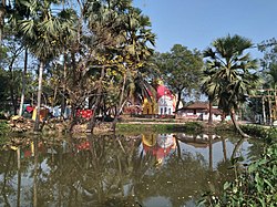 The temples from across the pond


Healthcare
[edit]Bhagabanpur Rural Hospital at Bhagabanpur (with 30 beds) is the main medical facility in Bhagabanpur I CD block. There are primary health centres at Bibhisanpur (with 10 beds), Kajlagarh (with 6 beds) and Seulipur, PO Paschimbarh (with 6 beds).[9]
Notable People
[edit]Dr Sheikh Taslim Ali, Professor (Asst.) of Epidemiology and Biostatistics, School of Public Health, The University of Hong Kong;[10] a Commonwealth scholar at Imperial College London, the United Kingdom for his doctoral program.
References
[edit]- ^ "District Statistical Handbook 2014 Purba Medinipur". Tables 2.1, 2.2. Department of Statistics and Programme Implementation, Government of West Bengal. Archived from the original on 21 January 2019. Retrieved 17 April 2019.
- ^ "Bhagwanpur PS". Purba Medinipur District Police. Archived from the original on 12 November 2016. Retrieved 10 November 2016.
- ^ "District Statistical Handbook 2014 Purba Medinipur". Table 2.2. Department of Planning and Statistics, Government of West Bengal. Archived from the original on 21 January 2019. Retrieved 17 April 2019.
- ^ "2011 Census – Primary Census Abstract Data Tables". West Bengal – District-wise. Registrar General and Census Commissioner, India. Retrieved 10 November 2016.
- ^ Google maps
- ^ "Bhagwanpur High School". ICBSE. Retrieved 30 March 2017.
- ^ "Bajkul Milani Mahavidyalaya". BMM. Retrieved 30 March 2017.
- ^ McCutchion, David J., Late Mediaeval Temples of Bengal, first published 1972, reprinted 2017, page 32. The Asiatic Society, Kolkata, ISBN 978-93-81574-65-2
- ^ "Health & Family Welfare Department". Health Statistics. Government of West Bengal. Archived from the original on 28 October 2021. Retrieved 27 March 2019.
- ^ https://sph.hku.hk/en/Biography/Ali-Sheikh-Taslim, Retrieved 27 July 2024.
External links
[edit]Cities, towns, locations and neighbourhoods in East Midnapore District, Medinipur division | ||||||||||
|---|---|---|---|---|---|---|---|---|---|---|
| Cities, municipal and census towns |
|  | ||||||||
| Locations other than cities and towns |
| |||||||||
| Neighbourhoods |
| |||||||||
| Related topics | ||||||||||