Kankalitala | |
|---|---|
Temple town/ village | |
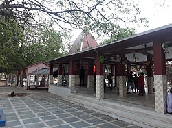 Kankalitala Temple | |
 Kankalitala Location in West Bengal, India | |
| Coordinates: 23°42′53″N 87°43′22″E / 23.714688°N 87.722815°E | |
| Country | |
| State | West Bengal |
| District | Birbhum |
| Languages | |
| • Official | Bengali, English |
| Time zone | UTC+5:30 (IST) |
| ISO 3166 code | IN-WB |
| Lok Sabha constituency | Bolpur |
| Vidhan Sabha constituency | Nanoor |
| Website | birbhum |
Kankalitala is a temple town in Bolpur Sriniketan CD block in Bolpur subdivision of Birbhum district in the Indian state of West Bengal.
Geography
[edit]
5miles
M: municipal city/ town, CT: census town, R: rural/ urban centre, U: University.
Owing to space constraints in the small map, the actual locations in a larger map may vary slightly
Location
[edit]It is located about 9 kilometres (5.6 mi) from Bolpur on the Bolpur–Labhpur road.[1] It is situated on the bank of the Kopai River.[2]
Note: The map alongside presents some of the notable locations in the area. All places marked in the map are linked in the larger full screen map.
Earlier, Kankalitala was marked as a gram panchayat under Bolpur-Sriniketan block.[3] However, in the 2011 census, it was not identified as a separate place, as per Google map and map of Bolpur-Sriniketan on page 718 of District Census Handbook Birbhum (Part A), it appears to be a part of Bengutia village.
Politics
[edit]As per orders of the Delimitation Commission, Kankalitala, Kasba, Sarpalehana Albandha, Sian Muluk and Singhee gram panchayats of Bolpur–Sriniketan CD Block will form part of Nanoor (Vidhan Sabha constituency) and Bolpur (Lok Sabha constituency).[4]
Culture
[edit]It is one of the Shakti Peethas where the waist (or kankal in Bengali) of sati fell.[1] There are several temples in the town. This is also a popular Hindu pilgrimage site of West Bengal.[5][6] There is another temple in Kankalitala, Kanchishwar Temple in Kankalitala Temple complex.
The Kankalitala Temple as a Shakti Peeth
[edit]
The mythology of Daksha yaga and Sati's self immolation is the story of origin behind Shakti Peethas. Shakti Peethas are holy abode of Devi formed due to the falling of body parts of the corpse of Sati Devi, when Shiva carried it and wandered through. There are 51 Shakti Peeth linking to the 51 alphabets in Sanskrit. Each temple has shrines for Shakti and Kalabhairava. The Shakti of the temple is addressed as "Devgarbha" and the Bhairava as "Ruru". It is believed that Sati Devi's bones have fallen here.[7][8]
References
[edit]- ^ a b "Kankalitala". District Administration. Retrieved 3 March 2009.
- ^ "Kankalitala". india9.com. Retrieved 3 March 2009.
- ^ "Directory of District, Sub division, Panchayat Samiti/ Block and Gram Panchayats in West Bengal, March 2008". West Bengal. National Informatics Centre, India. 19 March 2008. p. 1. Archived from the original (PDF) on 25 February 2009. Retrieved 28 February 2009.
- ^ "Press Note, Delimitation Commission" (PDF). Assembly Constituencies in West Bengal. Delimitation Commission. Archived from the original (PDF) on 29 May 2013. Retrieved 15 March 2009.
- ^ "কঙ্কালীতলা কেন মহান শক্তিপীঠ, জানুন?". Eisamay (in Bengali). Archived from the original on 25 July 2023. Retrieved 25 July 2023.
- ^ "জেনে নিন ইতিহাস, ঘুরে আসুন কঙ্কালীতলা শক্তিপীঠ, ৫১ সতীপীঠ পর্ব – ৪". www.amritobazar.com (in Bengali). Retrieved 25 July 2023.
- ^ "Kottiyoor Devaswam Temple Administration Portal". kottiyoordevaswom.com/. Kottiyoor Devaswam. Retrieved 20 July 2013.
- ^ "KANKHALESHWARI TEMPLE - West Bengal Tourism, Experience Bengal, Dept. of Tourism, Govt. of W. B." wbtourism.gov.in. Archived from the original on 15 January 2023. Retrieved 15 January 2023.
External links
[edit] Kankalitala travel guide from Wikivoyage