Bourzanga Department
Department in Centre-Nord Region, Burkina Faso
Bourzanga | |
|---|---|
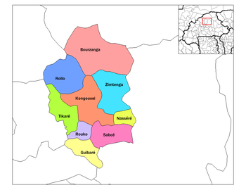 Bourzanga Department located in the north of the region | |
| Country |  Burkina Faso Burkina Faso |
| Region | Centre-Nord Region |
| Province | Bam Province |
| Area | |
| • Total | 414 sq mi (1,073 km2) |
| Population (2019 census) | |
| • Total | 103,266 |
| • Density | 250/sq mi (96/km2) |
| Time zone | UTC+0 (GMT 0) |
Bourzanga is a department of Bam Province in northern-central Burkina Faso. Its capital lies at Bourzanga town. According to the 2019 census the commune has a population of 103,266.[1]
Towns and villages
- Bourzanga (7 088 inhabitants) (capital)
- Abra (884 inhabitants)
- Alamanini (704 inhabitants)
- Alga (1 328 inhabitants)
- Alga-Fulbé (237 inhabitants)
- Bani (1 853 inhabitants)
- Bassé (2 138 inhabitants)
- Bassé-Fulbé (571 inhabitants)
- Bondé (409 inhabitants)
- Bonga (438 inhabitants)
- Bolkiba (287 inhabitants)
- Boulounga (2 296 inhabitants)
- Diagadéré (297 inhabitants)
- Doundégué (371 inhabitants)
- Felenga (428 inhabitants)
- Felenga Fulbé (513 inhabitants)
- Fétorané (380 inhabitants)
- Kiéké (831 inhabitants)
- Kièka Fulbé (125 inhabitants)
- Kourao (1 500 inhabitants)
- Maléoualé (793 inhabitants)
- Mawarida (225 inhabitants)
- Nafo (1 650 inhabitants)
- Namassa (233 inhabitants)
- Namssiguia (2 776 inhabitants)
- Napalgue (1 293 inhabitants)
- Nioumbila (1 725 inhabitants)
- Ouemtenga (259 inhabitants)
- Pissélé (1 026 inhabitants)
- Sam (2 060 inhabitants)
- Sam-Fulbé (467 inhabitants)
- Sanare (680 inhabitants)
- Selnore (1 628 inhabitants)
- Selnoré-Fulbé (47 inhabitants)
- Singtenga (831 inhabitants)
- Tabaongo (641 inhabitants)
- Tebera (968 inhabitants)
- Zana (1 620 inhabitants)
- Zana Mogo (976 inhabitants)
- Zomkalga (841 inhabitants)
- Zon (1 620 inhabitants)
[2]
References
- v
- t
- e
Capital: Kongoussi
- Bourzanga
- Abra
- Alamanini
- Alga
- Alga-Fulbé
- Bani
- Bassé
- Bassé-Fulbé
- Bondé
- Bonga
- Boulounga
- Bolkiba
- Diagadéré
- Doundégué
- Felenga
- Fétorané
- Felenga Fulbé
- Kiéké
- Kièka Fulbé
- Kourao
- Maléoualé
- Mawarida
- Nafo
- Namassa
- Namssiguia
- Napalgue
- Nioumbila
- Ouemtenga
- Pissélé
- Sam
- Sam-Fulbé
- Sanare
- Selnore
- Selnoré-Fulbé
- Singtenga
- Tabaongo
- Tebera
- Zana
- Zana Mogo
- Zomkalga
- Zon

- Kongoussi
- Badinogo-1
- Badinogo-2
- Birou
- Boalin
- Bogonam
- Bogonam-Foulbé
- Daribiti
- Daribiti
- Darigma
- Dinguilga
- Imieré
- Gonsé
- Kiella
- Kora
- Kora-Foulbé
- Kondibito
- Kougrisséogo
- Kouka
- Koumbango
- Kourpellé
- Loagha
- Loagha-Foulbé
- Lourgou
- Mogodin
- Nakindougou
- Niénéga-Mossi
- Niénéga-Foulbé
- Nongsom
- Nongsom-Foulbé
- Ranga
- Rambo-Wottionma
- Rissiam
- Sam
- Sakou
- Sakou-Foulbé
- Sandouré
- Sankondé
- Sargo
- Senopoguian
- Senorsingué
- Sorgho-Yargo
- Tamponga
- Tangaye
- Tanguiema
- Temnaoré
- Temnaoré-Foulbé
- Touka
- Woussé
- Yalga
- Yalgo
- Yalka
- Yougounini
- Zingguima
- Zoura
- Zoura-Foulbé
- Tikaré
- Ansouri
- Baribsi
- Boubou
- Dafire
- Dargouma
- Gasongo
- Gonga
- Hamdallaye
- Horé
- Ipala
- Kamtenga
- Kilou
- Koulniéré
- Manégtaba-Foulbé
- Manégtaba-Mossi
- Napalgué
- Ouampèga
- Oui
- Ritimyinga
- Sancé
- Sarkounga
- Songodin
- Soukoundougou
- Tamiga
- Tampèlga, Tikare
- Tanhoka
- Téonsgo
- Tirbou
- Touga
- Vato-Foulbé
- Vato-Mossi
- Yelkoto
- Yoba
- Zamsé
- Zano
- Zimtenga
- Bangrin
- Bargo
- Batanga
- Bayendfoulgo
- Bonda
- Dénéon
- Dougré
- Douré
- Gasdonka
- Kalagré-Foulbé
- Kalagré-Mossi
- Kalagrérimaïbé
- Kaokana-Peulh
- Kargo
- Kayon
- Kiendyendé
- Komsilga
- Konkin-Foulgo
- Konkin-Moogo
- Loa
- Minima
- Moméné
- Niniongo
- Nordé
- Paspanga
- Pètakakisgou
- Pissi
- Rakoegtanga
- Rolga
- Romtanghin
- Siguinvoussé
- Singa-Mossi
- Singa-Rimaïbé
- Sissin
- Songédin-Yarcé
- Tampèlga
- Tankoulounga
- Toéssin
- Wattigué
- Yalgatinga
13°40′41″N 1°32′46″W / 13.67806°N 1.54611°W / 13.67806; -1.54611
 | This Bam Province location article is a stub. You can help Wikipedia by expanding it. |
- v
- t
- e


