Byram, Connecticut
Census-designated place in Connecticut, United States
Byram, Connecticut | |
|---|---|
Census-designated place | |
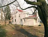 Phebe Seaman House (1794), 170 Byram Road | |
 Location in Fairfield County and the state of Connecticut. | |
| Country |  United States United States |
| U.S. state |  Connecticut Connecticut |
| County | Fairfield |
| NECTA | Bridgeport-Stamford-Norwalk |
| Region | Western CT |
| Town | Greenwich |
| Area | |
| • Total | 0.861 sq mi (2.23 km2) |
| • Land | 0.798 sq mi (2.07 km2) |
| • Water | 0.063 sq mi (0.16 km2) |
| Population (2010) | |
| • Total | 4,146 |
| • Density | 4,800/sq mi (1,900/km2) |
| Time zone | Eastern |
| Area code(s) | 203 |
| FIPS code | 09-10660 |
| GNIS feature ID | 2631559 |
Byram is a neighborhood/section and census-designated place (CDP) in the town of Greenwich in Fairfield County, Connecticut, United States.[1] It had a population of 4,146 at the 2010 census,[2] and a census-estimated population of 4,216 in 2018.[3] An endcap of Connecticut's Gold Coast, Byram is the southernmost point in the town of Greenwich and the U.S. state of Connecticut. It is separated from Port Chester, Westchester County, New York, by the Byram River. Byram was once known as East Port Chester.
History
The town of Greenwich is one political and taxing body, but consists of several distinct sections or neighborhoods, such as Banksville, Byram, Cos Cob, Glenville, Mianus, Old Greenwich, Riverside and Greenwich (sometimes referred to as central, or downtown, Greenwich). Of these neighborhoods, three (Cos Cob, Old Greenwich, and Riverside) have separate postal names and ZIP codes.

Byram Quarry, now closed, supplied stone for the Brooklyn Bridge, the base of the Statue of Liberty and St. Roch Church.[4]
Geography
According to the United States Census Bureau, Byram has a total area of 0.861 square miles (2.23 km2), of which 0.798 square miles (2.07 km2) is land and 0.063 square miles (0.16 km2), or 7.32%, is water.[5]
Culture
A scene from the movie The Good Shepherd was shot in Byram.[6][7]
Places
Byram has three sites on the National Register of Historic Places:
- Phebe Seaman House (1794), 170 Byram Road; built c. 1794
- Thomas Lyon House — 1 Byram Road; built: c. 1695, listed: 1977
- Byram School — Western Junior Highway; built: 1925, listed: 1990
Library
Notes
- ^ U.S. Geological Survey Geographic Names Information System: Byram, Connecticut
- ^ "Race, Hispanic or Latino, Age, and Housing Occupancy: 2010 Census Redistricting Data (Public Law 94-171) Summary File (QT-PL), Byram CDP, Connecticut". United States Census Bureau. Retrieved August 11, 2011.
- ^ "ACS 2018 Demographic and Housing Estimates". data.census.gov. Retrieved February 2, 2020.
- ^ Hagey, Keach, "No givebacks: Group rejects war memorial for school", The Advocate of Stamford, September 28, 2006, page A3; article from Greenwich Time daily newspaper
- ^ "US Gazetteer files: 2019". United States Census Bureau. Retrieved October 10, 2020.
- ^ ""The Good Shepherd" House in Greenwich, CT". Virtual Globetrotting. January 16, 2009. Retrieved July 23, 2020.
- ^ Lewis, Christina S.N. (January 16, 2009). "Christian Lacroix Offers Paris Apartment". The Wall Street Journal. Retrieved July 23, 2020.
- v
- t
- e
Geography
neighborhoods
- Calf Island
- Great Captain Island
Education
secondary schools
| Closed |
|---|
Other
- Bush–Holley House
- Byram School
- Cos Cob station
- Cos Cob Power Station
- Samuel Ferris House
- Glenville School
- Great Captain Island Light
- Greenwich Town Hall
- Greenwich Y.M.C.A.
- Indian Harbor Yacht Club building
- Thomas Lyon House
- Mianus River Railroad Bridge
- The Nathaniel Witherell
- Methodist Episcopal Church
- New Mill and Depot Building, Hawthorne Woolen Mill
- Old Greenwich station
- Phebe Seaman House
- Putnam Cottage (Knapp Tavern)
- Riverside Avenue Bridge
- Rosemary Hall
- Sylvanus Selleck Gristmill
- United States Post Office Greenwich Main
- William E. Ward House
- Josiah Wilcox House
- Cos Cob station
- Old Greenwich station
- Riverside station (Metro-North)
- Greenwich Hospital
This list is incomplete.
Some areas with "Greenwich, Connecticut" postal addresses are in Banksville, New York. These areas are not in this template.
Some areas with "Greenwich, Connecticut" postal addresses are in Banksville, New York. These areas are not in this template.

41°00′15″N 73°39′13″W / 41.00417°N 73.65361°W / 41.00417; -73.65361
Authority control databases | |
|---|---|
| International |
|
| National |
|
 | This Connecticut state location article is a stub. You can help Wikipedia by expanding it. |
- v
- t
- e


