Canaan, Connecticut
Town in Connecticut, United States

Seal
 Litchfield County and Connecticut
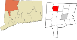 Northwest Hills Planning Region and Connecticut
 United States
 Connecticut
Greg Marlowe (R)
(2020)
06031
Canaan is a town in Litchfield County, Connecticut, United States. The population was 1,080 at the 2020 census,[1] down from 1,234 at the 2010 census. The town is part of the Northwest Hills Planning Region. The town of Canaan is often referred to locally by the name of its principal settlement, Falls Village.[2]
Geography
Canaan is in northwestern Litchfield County; it is bordered to the north by the town of North Canaan, to the east by Norfolk, to the south by Cornwall, and to the west, across the Housatonic River, by Salisbury. It is 17 miles (27 km) northwest of Torrington, 46 miles (74 km) north of Danbury, and 17 miles (27 km) south of Great Barrington, Massachusetts.
According to the United States Census Bureau, the town of Canaan has a total area of 33.2 square miles (86.1 km2), of which 32.9 square miles (85.2 km2) are land and 0.3 square miles (0.8 km2), or 0.97%, are water.[3]
Principal communities
- Falls Village (town center)
- Huntsville
- Lower City
- South Canaan
History
The town was incorporated in 1739. The name "Canaan" is derived from Hebrew.[4]
Demographics
| Census | Pop. | Note | %± |
|---|---|---|---|
| 1820 | 2,332 | — | |
| 1850 | 2,627 | — | |
| 1860 | 1,408 | −46.4% | |
| 1870 | 1,257 | −10.7% | |
| 1880 | 1,157 | −8.0% | |
| 1890 | 970 | −16.2% | |
| 1900 | 820 | −15.5% | |
| 1910 | 702 | −14.4% | |
| 1920 | 561 | −20.1% | |
| 1930 | 565 | 0.7% | |
| 1940 | 555 | −1.8% | |
| 1950 | 708 | 27.6% | |
| 1960 | 790 | 11.6% | |
| 1970 | 931 | 17.8% | |
| 1980 | 1,002 | 7.6% | |
| 1990 | 1,057 | 5.5% | |
| 2000 | 1,081 | 2.3% | |
| 2010 | 1,234 | 14.2% | |
| 2020 | 1,080 | −12.5% | |
| U.S. Decennial Census[5] | |||
As of the census[6] of 2000, there were 1,081 people, 445 households, and 298 families residing in the town. The population density was 32.8 inhabitants per square mile (12.7/km2). There were 610 housing units at an average density of 18.5 per square mile (7.1/km2). The racial makeup of the town was 97.04% White, 1.48% Black or African American, 0.19% Asian, 0.09% Pacific Islander, 0.37% from other races, and 0.83% from two or more races. Hispanic or Latino people of any race were 0.37% of the population.
There were 445 households, out of which 30.3% had children under the age of 18 living with them, 57.8% were married couples living together, 7.2% had a female householder with no husband present, and 33.0% were non-families. 27.6% of all households were made up of individuals, and 10.6% had someone living alone who was 65 years of age or older. The average household size was 2.43 and the average family size was 2.97.
In the town, the population was spread out, with 23.6% under the age of 18, 5.9% from 18 to 24, 27.5% from 25 to 44, 28.8% from 45 to 64, and 14.2% who were 65 years of age or older. The median age was 42 years. For every 100 females, there were 95.1 males. For every 100 females age 18 and over, there were 98.6 males.
The median income for a household in the town was $54,688, and the median income for a family was $62,500. Males had a median income of $40,438 versus $29,219 for females. The per capita income for the town was $35,841. About 3.0% of families and 4.7% of the population were below the poverty line, including 5.6% of those under age 18 and 3.8% of those age 65 or over.
| Voter registration and party enrollment as of October 29, 2019[7] | |||||
|---|---|---|---|---|---|
| Party | Active voters | Inactive voters | Total voters | Percentage | |
| Republican | 150 | 26 | 176 | 21.86% | |
| Democratic | 297 | 20 | 317 | 39.38% | |
| Unaffiliated | 258 | 50 | 308 | 38.26% | |
| Minor Parties | 4 | 0 | 4 | 0.50% | |
| Total | 709 | 96 | 805 | 100% | |
| Presidential Election Results[8][9] | |||
|---|---|---|---|
| Year | Democratic | Republican | Third Parties |
| 2020 | 66.7% 437 | 31.9% 209 | 1.4% 9 |
| 2016 | 60.3% 357 | 34.3% 203 | 5.4% 32 |
| 2012 | 63.4% 384 | 34.7% 210 | 1.9% 12 |
| 2008 | 67.7% 429 | 29.8% 189 | 2.5% 16 |
| 2004 | 61.1% 378 | 35.4% 219 | 3.5% 22 |
| 2000 | 49.1% 288 | 35.9% 211 | 15.0% 88 |
| 1996 | 50.8% 302 | 30.3% 180 | 18.9% 112 |
| 1992 | 41.2% 237 | 33.4% 192 | 25.4% 146 |
| 1988 | 46.3% 241 | 52.6% 274 | 1.1% 6 |
| 1984 | 28.2% 151 | 71.0% 380 | 0.8% 4 |
| 1980 | 30.4% 153 | 54.6% 275 | 15.0% 76 |
| 1976 | 36.4% 170 | 61.2% 289 | 2.4% 8 |
| 1972 | 28.8% 146 | 70.6% 358 | 0.6% 3 |
| 1968 | 32.4% 140 | 64.4% 278 | 3.2% 14 |
| 1964 | 47.1% 202 | 52.9% 227 | 0.00% 0 |
| 1960 | 20.7% 89 | 79.3% 341 | 0.00% 0 |
| 1956 | 16.4% 68 | 83.6% 346 | 0.00% 0 |
Education
Canaan is a member of Regional School District 1, which also includes the towns of Cornwall, Kent, North Canaan, Salisbury, and Sharon. Public school students attend Lee H. Kellogg School for grades K–8, and Housatonic Valley Regional High School for grades 9–12.
Notable people
- Philo Belden, Wisconsin politician
- Steve Blass, former Major League Baseball pitcher and current broadcaster[10]
- Major Felten, artist and illustrator
- James Mars, slave narrative author[11]
- Judson Philips, author of mystery novels[12]
- Cyrus Prindle, abolitionist and one of the founders of the Wesleyan Church
- Lemuel Roberts, Revolutionary War soldier and historian, born in Canaan in 1755[13]
- Catherine Roraback, civil rights attorney[14]
- Bates Turner, Vermont politician and jurist[15]
- Elizur Wright, the "father of life insurance"
Transportation
The town is served by U.S. Route 7, Route 63, and Route 126. US 7 leads north into Massachusetts and south to Danbury, while Route 63 leads southeast to Litchfield. Route 126 is a local road that passes through the center of Falls Village and runs north along the Housatonic River.
Pictures
-
 Purportedly "famous" elm, c. 1910
 -
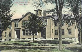 High school, 1910
 -


References
- ^ "Census - Geography Profile: Canaan town, Litchfield County, Connecticut". United States Census Bureau. Retrieved November 27, 2021.
- ^ Early Historical Highlights of the Town of Canaan (Commonly Known As Falls Village) Archived April 5, 2009, at the Wayback Machine, Town of Canaan website
- ^ "Geographic Identifiers: 2010 Census Summary File 1 (G001), Canaan town, Litchfield County, Connecticut". American FactFinder. U.S. Census Bureau. Archived from the original on February 13, 2020. Retrieved October 4, 2019.
- ^ The Connecticut Magazine: An Illustrated Monthly. Connecticut Magazine Company. 1903. p. 331.
- ^ "Census of Population and Housing". Census.gov. Retrieved June 4, 2015.
- ^ "U.S. Census website". United States Census Bureau. Retrieved January 31, 2008.
- ^ "Registration and Party Enrollment Statistics as of October 29, 2019" (PDF). Connecticut Secretary of State.
- ^ "General Election Statements of Vote, 1922 – Current". CT Secretary of State. Retrieved December 19, 2020.
- ^ "Election Night Reporting". CT Secretary of State. Retrieved December 19, 2020.
- ^ "Steve Blass". Society for American Baseball Research. Retrieved May 23, 2014.
- ^ Hinks, Peter P. (February 28, 2015). "James Mars' Words Illuminate the Cruelty of Slavery in New England". Connecticut History | a CTHumanities Project. Retrieved February 2, 2022.
- ^ "Judson Philips, 85, Author, Dies". New York Times. March 9, 1989. Retrieved May 23, 2014.
- ^ "Pane-Joyce Genealogy". Clark University. Archived from the original on June 25, 2010. Retrieved May 30, 2010.
- ^ "Catherine Roraback". Connecticut Women's Hall of Fame. Retrieved May 23, 2014.
- ^ Lewis Cass Aldrich, ed. (1891). HISTORY OF Franklin AND Grand Isle Counties VERMONT. Syracuse, N Y.: D. Mason & Co. pp. 225–226.
External links
Wikimedia Commons has media related to Canaan, Connecticut.
 Connecticut portal

- Town of Canaan official website
- Falls Village-Canaan Historical Society
- Northwest Connecticut Arts Council
- Northwest Connecticut Convention and Visitors Bureau
- v
- t
- e
Municipalities and communities of Northwest Hills Planning Region, Connecticut, United States

- Connecticut portal
- United States portal
Municipalities and communities of Litchfield County, Connecticut, United States | ||
|---|---|---|
County seat: Litchfield | ||
| Consolidated city |  | |
| Towns | ||
| Boroughs |
| |
| CDPs |
| |
| Other communities | ||
| Indian reservation | ||
| Footnotes | ‡This populated place also has portions in an adjacent county or counties. | |
| ||

| |||||||
|---|---|---|---|---|---|---|---|
| Topics | |||||||
| States | |||||||
| Major cities | |||||||
| State capitals | |||||||
| Transportation |
| ||||||
| |||||||


Authority control databases | |
|---|---|
| International |
|
| National |
|


