Claypool (Western Apache: Goshtłʼish Tú[2]) is a census-designated place (CDP) in Gila County, Arizona, United States. The population was 1,538 at the 2010 census,[3] down from 1,794 at the 2000 census. It was named after W. D. Claypool, a member of both the State House of Representatives and State Senate in the 1910s and 1920s.[4]
Geography
Claypool is located in southern Gila County at 33°24′31″N110°50′51″W / 33.40861°N 110.84750°W / 33.40861; -110.84750 (33.408626, -110.847532),[5] between Miami to the west and Globe, the county seat, to the east. U.S. Route 60 runs along the northern edge of the community.
As of the census[8] of 2000, there were 1,794 people, 683 households, and 486 families residing in the CDP. The population density was 1,479.1 inhabitants per square mile (571.1/km2). There were 786 housing units at an average density of 648.0 per square mile (250.2/km2). The racial makeup of the CDP was 78.5% White, 1.0% Black or African American, 1.6% Native American, 0.1% Asian, 15.8% from other races, and 3.1% from two or more races. 41.0% of the population were Hispanic or Latino of any race.
There were 683 households, out of which 29.9% had children under the age of 18 living with them, 55.5% were married couples living together, 11.3% had a female householder with no husband present, and 28.8% were non-families. 24.6% of all households were made up of individuals, and 13.2% had someone living alone who was 65 years of age or older. The average household size was 2.63 and the average family size was 3.14.
In the CDP, the population was spread out, with 27.8% under the age of 18, 7.3% from 18 to 24, 23.2% from 25 to 44, 25.9% from 45 to 64, and 15.7% who were 65 years of age or older. The median age was 39 years. For every 100 females, there were 93.3 males. For every 100 females age 18 and over, there were 89.6 males.
The median income for a household in the CDP was $34,196, and the median income for a family was $47,593. Males had a median income of $33,571 versus $23,661 for females. The per capita income for the CDP was $16,246. About 6.4% of families and 12.1% of the population were below the poverty line, including 16.4% of those under age 18 and 15.0% of those age 65 or over.
Gallery
The Claypool Tunnel – The abandoned tunnel was built in 1926 in the Superstition Mountains, as part of the old US Hwy 60 system.[9]
Images of Claypool
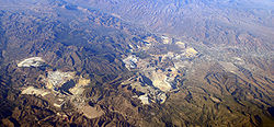
Panorama of mining operations, Claypool and Miami, Arizona
^"2020 U.S. Gazetteer Files". United States Census Bureau. Retrieved October 29, 2021.
^William J. de Reuse (2006), A Practical Grammar of the San Carlos Apache Language, Lincom Europa
^ ab"Geographic Identifiers: 2010 Demographic Profile Data (G001): Claypool CDP, Arizona". U.S. Census Bureau, American Factfinder. Retrieved October 31, 2016.[dead link]
^Barnes, Will Croft (2016). Arizona Place Names. Tucson: University of Arizona Press. p. 203. ISBN 978-0816534951. Archived from the original on May 23, 2022.
^"US Gazetteer files: 2010, 2000, and 1990". United States Census Bureau. February 12, 2011. Retrieved April 23, 2011.

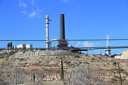 Freeport Mcmoran Copper Smelter, Claypool
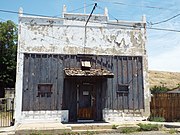 Abandoned 1900 store
 1901 building in Claypool
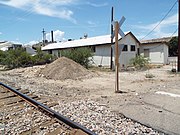 Abandoned 1885 Arizona Eastern Railway Depot
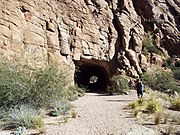 Claypool Tunnel
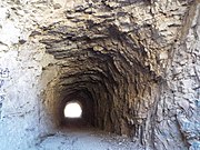 Different view of the Claypool Tunnel


