De Loonse en Drunense Duinen National Park
National park in the Netherlands
51°38′52″N 5°06′53″E / 51.64778°N 5.11472°E / 51.64778; 5.11472
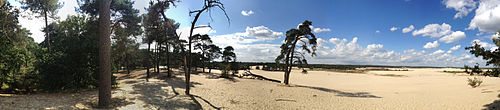
De Loonse en Drunense Duinen National Park (duinen = dunes) is a national park situated in the south of the Netherlands, between the cities of Tilburg, Waalwijk and 's-Hertogenbosch. It has been designated as a national park since 2002. It is 35 km2 (14 mile²) in area, and located in the municipalities of Loon op Zand, Heusden, and Vught.
The Loonse en Drunense Duinen consists of forests and very large dunes, creating an extraordinary microclimate.
References
- ^ (in Dutch) https://nationaalpark.nl/park/nationaal-park-loonse-en-drunense-duinen/ Nationaal park Loonse en Drunense Duinen
External links
- Official website
Wikimedia Commons has media related to Loonse en Drunense Duinen.
- v
- t
- e
- Alde Feanen
- Biesbosch
- Drents-Friese Wold
- Drentsche Aa
- Duinen van Texel
- Dwingelderveld
- Groote Peel
- Hoge Veluwe
- Lauwersmeer
- Loonse en Drunense Duinen
- Maasduinen
- Meinweg
- Nieuw Land
- Oosterschelde
- Sallandse Heuvelrug
- Schiermonnikoog
- Utrechtse Heuvelrug
- Van Gogh (proposed)
- Veluwezoom
- Weerribben-Wieden
- Zoom–Kalmthoutse Heide
- Zuid-Kennemerland
Authority control databases | |
|---|---|
| International |
|
| National |
|


