Dobele District
District of Latvia
District in Latvia
Dobele | |
|---|---|
District | |
 | |
| Country | Latvia |
| Area | |
| • Total | 1,632 km2 (630 sq mi) |
| Population | |
| • Total | 37,713 |
| • Density | 23/km2 (60/sq mi) |
| Website | dobelesrp.lv/ |
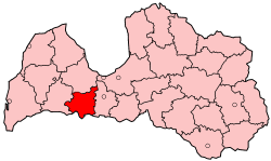
Dobele District (Latvian: Dobeles rajons) was an administrative division of Latvia, located in the Courland and Semigallia regions, in the country's centre. It was organized into two cities, a municipality and fifteen parishes, each with a local government authority.[1] The main city in the district was Dobele.
Districts were eliminated during the administrative-territorial reform in 2009.
Cities, municipalities and parishes of the Dobele District
- Annenieki Parish
- Auce city
- Auri Parish
- Bēne Parish
- Bērze Parish
- Biksti Parish
- Dobele city
- Dobele Parish
- Īle Parish
- Jaunbērze Parish
- Krimūna Parish
- Lielauce Parish
- Naudīte Parish
- Penkule Parish
- Tērvete municipality
- Ukri Parish
- Vītiņi Parish
- Zebrene Parish
References
- ^ "Pašvaldības" (in Latvian). dobelesrp.lv. Archived from the original on 15 March 2008. Retrieved 3 March 2008.
- v
- t
- e
Cities, Municipalities and Parishes of the defunct Dobele District
| Authority control databases: National |
|
|---|
56°37′N 23°16′E / 56.617°N 23.267°E / 56.617; 23.267
 | This Courland location article is a stub. You can help Wikipedia by expanding it. |
- v
- t
- e
 | This Semigallia location article is a stub. You can help Wikipedia by expanding it. |
- v
- t
- e


