Eastern Region, Venezuela
Administrative region of Venezuela

The Eastern Region is one of the 10 administrative regions in which Venezuela was divided for its development plans; it comprises the states of Anzoátegui, Monagas, and Sucre.

History
The state of Sucre has great historical importance, because it was the first Venezuelan land touched by the Italian navigator, Christopher Columbus. Columbus, impressed by the greenness of the flora, the coasts and the crystalline water of its beaches, called the place "Tierra de Gracia" or 'Land of Grace'.
While the State of Anzoategui was initially called Province of Barcelona in reference to the Spanish city of the same name, while the capital kept its original name (Barcelona) the territory received the name of a Venezuelan general.

In 1856, the Province of Maturín was created, separated from that of Cumaná. By 1864 the Maturín State was ratified. But in 1879, Monagas was annexed to the State of Oriente and, from 1891 to 1898, it belonged to the State of Bermúdez.
In 1904, Maturín became the capital of the Monagas district of Bermúdez State, whose capital was Cumaná. In 1909, Monagas State was created with its current boundaries. In honor of General José Tadeo Monagas.
Geography
It is bordered to the north by the Caribbean Sea and the Insular Region; to the south by the state of Bolivar; to the east by the state of Delta Amacuro and the Gulf of Paria; and to the west by the states of Miranda and Guarico.[citation needed]
Demographics
The population of the north-eastern region amounts to 3,316,182 inhabitants, representing 12 per cent of the national population; it is distributed over a territory of 84,000 km2, determining a population density equal to 39.5 inhabitants per km2.
Gallery
-
 Paraíso Island, Lechería, Anzoátegui State
 -
 Isla El Faro Mochima National Park
 -
 San Luis Beach, Sucre State
 -
 Medina Beach, Paria Peninsula
 -
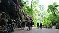 Guácharo Cave National Park, Monagas State


- v
- t
- e
- Caracas

- Los Monjes Archipelago
- Las Aves Archipelago
- Aves Island
- Los Hermanos Archipelago
- Los Frailes Archipelago
- Los Roques Archipelago
- La Sola Island
- La Tortuga Island
- La Orchila Island
- La Blanquilla Island
- Los Testigos Islands
- Patos Island
- Francisco de Miranda Insular Territory [es]
- Federal Territories
- Amazonas Federal Territory (1864–1992)
- Delta Amacuro Federal Territory (1884–1991)
10°08′00″N 64°41′00″W / 10.1333°N 64.6833°W / 10.1333; -64.6833
 | This article about a location in Venezuela is a stub. You can help Wikipedia by expanding it. |
- v
- t
- e


