Grade I and II* listed buildings in the London Borough of Barnet
Map all coordinates using OpenStreetMap
Download coordinates as:
- KML
- GPX (all coordinates)
- GPX (primary coordinates)
- GPX (secondary coordinates)
There are over 9,000 Grade I listed buildings and 20,000 Grade II* listed buildings in England. This page is a list of these buildings in the London Borough of Barnet.
Grade I
| Name | Location | Type | Completed [note 1] | Date designated | Grid ref.[note 2] Geo-coordinates | Entry number [note 3] | Image |
|---|---|---|---|---|---|---|---|
| Church of St Jude | Central Square, Hampstead Garden Suburb, NW11 7AH | Church | 1908–10 | 18 March 1965 | TQ2551688361 51°34′49″N 0°11′24″W / 51.580143°N 0.189945°W / 51.580143; -0.189945 (Church of St Jude) | 1294714 | 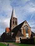 More images |
| The Free Church | North Square, Hampstead Garden Suburb, NW11 7AA | Nonconformist chapel | 1908–10 | 18 March 1965 | TQ2544988471 51°34′52″N 0°11′27″W / 51.581146°N 0.190872°W / 51.581146; -0.190872 (The Free Church) | 1078866 |  More images |
Grade II*
| Name | Location | Type | Completed [note 1] | Date designated | Grid ref.[note 2] Geo-coordinates | Entry number [note 3] | Image |
|---|---|---|---|---|---|---|---|
| Arkley Windmill | Grounds of Windmill House, Windmill Lane, Arkley, EN5 3LD | Tower mill | 1822–40 | 1 February 1950 | TQ2172295284 51°38′35″N 0°14′32″W / 51.643192°N 0.24227°W / 51.643192; -0.24227 (Arkley Windmill) | 1359022 |  More images |
| Church Farmhouse Museum | 46 Church End, Hendon, NW4 4JT | Farmhouse | Mid-17th century | 3 February 1950 | TQ2283189546 51°35′29″N 0°13′42″W / 51.591384°N 0.228261°W / 51.591384; -0.228261 (Church Farmhouse Museum) | 1188513 |  More images |
| Church of St John the Baptist | Wood Street, Chipping Barnet, EN5 4BW | Church | Mid-15th century | 1 February 1950 | TQ2455796463 51°39′11″N 0°12′03″W / 51.653167°N 0.200901°W / 51.653167; -0.200901 (Church of St John the Baptist) | 1359101 |  More images |
| Church of St John the Evangelist | Friern Barnet Road, Friern Barnet, N11 3EQ | Church | c.1891 | 24 February 1949 | TQ2787992088 51°36′47″N 0°09′16″W / 51.613106°N 0.154504°W / 51.613106; -0.154504 (Church of St John the Evangelist) | 1359056 |  More images |
| Hadley House | Hadley Green Road, Monken Hadley, EN5 5PR | House | c.1760 | 18 July 1949 | TQ2477597289 51°39′38″N 0°11′51″W / 51.660542°N 0.197457°W / 51.660542; -0.197457 (Hadley House) | 1078824 | 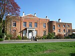 More images |
| Stable block to Hadley House | Hadley Green Road, Monken Hadley, EN5 5PR | Stable | c.1760 | 18 July 1949 | TQ2475197252 51°39′37″N 0°11′52″W / 51.660215°N 0.197817°W / 51.660215; -0.197817 (Stable block to Hadley House) | 1293470 |  |
| Hadley Hurst | Hadley Common, Monken Hadley, EN5 5QG | House | c.1700 | 18 July 1949 | TQ2533297139 51°39′33″N 0°11′22″W / 51.65907°N 0.189462°W / 51.65907; -0.189462 (Hadley Hurst) | 1188803 |  More images |
| Hawthorne Dene | Strawberry Vale, East Finchley, N2 9AA | House | c.1825–26 | 4 June 1971 | TQ2669590790 51°36′06″N 0°10′19″W / 51.601708°N 0.172063°W / 51.601708; -0.172063 (Hawthorne Dene) | 1359105 | 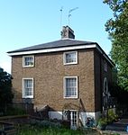 More images |
| Holcombe House | The Ridgeway, Mill Hill, NW7 4HY | Villa | c.1775–78 | 3 February 1950 | TQ2215893075 51°37′24″N 0°14′12″W / 51.623245°N 0.236743°W / 51.623245; -0.236743 (Holcombe House) | 1064845 |  More images |
| Mausoleum to the Philipson Family, Golders Green Crematorium | Golders Green Crematorium, 62 Hoop Lane, NW11 7NL | Mausoleum | 1914–15 | 19 July 1985 | TQ2538387983 51°34′36″N 0°11′31″W / 51.576776°N 0.191998°W / 51.576776; -0.191998 (Mausoleum to the Philipson Family, Golders Green Crematorium) | 1064788 |  More images |
| 22 South Square | South Square, Hampstead Garden Suburb, NW11 7AJ | Detached house | 1930[1] | 18 March 1965 | TQ2562488355 51°34′48″N 0°11′18″W / 51.580065°N 0.188389°W / 51.580065; -0.188389 (22 South Square) | 1064860 |  |
| 1 and 2 South Square | South Square, Hampstead Garden Suburb, NW11 7AL | House | 1915–36 | 18 March 1965 | TQ2548088310 51°34′47″N 0°11′26″W / 51.579693°N 0.190483°W / 51.579693; -0.190483 (1 and 2 South Square) | 1192116 |  More images |
| 19 and 20 South Square | South Square, Hampstead Garden Suburb, NW11 | House | 1930[1] | 18 March 1965 | TQ2560288325 51°34′47″N 0°11′19″W / 51.5798°N 0.188717°W / 51.5798; -0.188717 (19 and 20 South Square) | 1192125 |  |
| 23 South Square | South Square, Hampstead Garden Suburb, NW11 | House | 1930[1] | 18 March 1965 | TQ2561588370 51°34′49″N 0°11′19″W / 51.580202°N 0.188514°W / 51.580202; -0.188514 (23 South Square) | 1286728 |  |
| 24 South Square | South Square, Hampstead Garden Suburb, NW11 | House | 1930[1] | 18 March 1965 | TQ2560788384 51°34′49″N 0°11′19″W / 51.580329°N 0.188624°W / 51.580329; -0.188624 (24 South Square) | 1359086 |  |
| 1–8 North Square | South Square, Hampstead Garden Suburb, NW11 | House | 1907–10[1] | 18 March 1965 | TQ2536788498 51°34′53″N 0°11′31″W / 51.581407°N 0.192045°W / 51.581407; -0.192045 (1–8 North Square) | 1359058 |  More images |
| 3–18 South Square | South Square, Hampstead Garden Suburb, NW11 | Terrace | 1928[1] | 18 March 1965 | TQ2551988282 51°34′46″N 0°11′24″W / 51.579432°N 0.18993°W / 51.579432; -0.18993 (3–18 South Square) | 1359085 |  More images |
| 21 South Square | South Square, Hampstead Garden Suburb, NW11 | Detached house | 1930[1] | 18 March 1965 | TQ2562388336 51°34′48″N 0°11′18″W / 51.579894°N 0.188411°W / 51.579894; -0.188411 (21 South Square) | 1064859 |  |
| 9-12 and 15 North Square | North Square, Hampstead Garden Suburb, NW11 | House | 1920 | 18 March 1965 | TQ2544488553 51°34′55″N 0°11′27″W / 51.581884°N 0.190915°W / 51.581884; -0.190915 (9-12 and 15 North Square) | 1191775 |  More images |
| 78-90 Corringham Road | Corringham Road, Hampstead Garden Suburb, NW11 7EB | House | 1912–13 | 18 March 1965 | TQ2561587688 51°34′27″N 0°11′20″W / 51.574073°N 0.188758°W / 51.574073; -0.188758 (78-90 Corringham Road) | 1078830 |  More images |
| 101, 103–115, and 117 Corringham Road | Corringham Road, Hampstead Garden Suburb, NW11 7DL | House | 1912–13 | 18 March 1965 | TQ2558587736 51°34′28″N 0°11′21″W / 51.574511°N 0.189173°W / 51.574511; -0.189173 (101, 103–115, and 117 Corringham Road) | 1078831 |  More images |
| Parish Church of St Mary | Hendon | Parish church | Mid-13th century | 3 February 1950 | TQ2287189561 51°35′29″N 0°13′40″W / 51.59151°N 0.227678°W / 51.59151; -0.227678 (Parish Church of St Mary) | 1359029 |  More images |
| Parish Church of St Mary | Finchley | Parish church | 15th century | 18 October 1949 | TQ2492490524 51°35′59″N 0°11′52″W / 51.599713°N 0.197715°W / 51.599713; -0.197715 (Parish Church of St Mary) | 1287095 |  More images |
| Parish Church of St Mary the Virgin | East Barnet | Church | c.1080 | 18 July 1949 | TQ2770794554 51°38′07″N 0°09′22″W / 51.635306°N 0.156088°W / 51.635306; -0.156088 (Parish Church of St Mary the Virgin) | 1078869 |  More images |
| Parish Church of St Mary the Virgin | Monken Hadley | Church | 1471 | 18 July 1949 | TQ2501697411 51°39′42″N 0°11′38″W / 51.661585°N 0.193931°W / 51.661585; -0.193931 (Parish Church of St Mary the Virgin) | 1078819 | 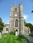 More images |
| St Martha's Convent (the Mount House) with Attached Stable Block | Monken Hadley | House | Mid-18th century | 18 July 1949 | TQ2534097636 51°39′49″N 0°11′21″W / 51.663535°N 0.189169°W / 51.663535; -0.189169 (St Martha's Convent (the Mount House) with Attached Stable Block) | 1359027 |  More images |
| Henrietta Barnett School (formerly The Institute) | Central Square, Hampstead Garden Suburb | School | 18 March 1965 | TQ2556788466 51°34′52″N 0°11′21″W / 51.581075°N 0.189172°W / 51.581075; -0.189172 (Henrietta Barnett School (formerly The Institute)) | 1359028 |  More images | |
| The Manor House | Barnet | House | Early 18th century | 18 October 1949 | TQ2551790047 51°35′43″N 0°11′22″W / 51.595295°N 0.189328°W / 51.595295; -0.189328 (The Manor House) | 1188600 |  More images |
| The Manse | Hampstead Garden Suburb | House | 1911 | 18 March 1965 | TQ2547788507 51°34′53″N 0°11′26″W / 51.581464°N 0.190456°W / 51.581464; -0.190456 (The Manse) | 1064880 |  |
| The Vicarage | Golders Green | House | 1911[1] | 18 March 1965 | TQ2555988368 51°34′49″N 0°11′22″W / 51.580196°N 0.189322°W / 51.580196; -0.189322 (The Vicarage) | 1064861 |  |
| Waterlow Court | Hampstead Garden Suburb | Flats | 1908–09 | 18 March 1965 | TQ2558887558 51°34′22″N 0°11′21″W / 51.572911°N 0.189193°W / 51.572911; -0.189193 (Waterlow Court) | 1064889 |  More images |
| Wyldes | Hampstead Garden Suburb | Barn | 17th century | 29 March 1963 | TQ2610487138 51°34′08″N 0°10′55″W / 51.569021°N 0.181902°W / 51.569021; -0.181902 (Wyldes) | 1359046 |  |
| Wyldes Farm | Hampstead Garden Suburb | Farmhouse | 17th century or earlier | 29 March 1963 | TQ2611887147 51°34′09″N 0°10′54″W / 51.569099°N 0.181697°W / 51.569099; -0.181697 (Wyldes Farm) | 1191239 |  More images |
Wikimedia Commons has media related to Grade I listed buildings in the London Borough of Barnet.
Wikimedia Commons has media related to Grade II* listed buildings in the London Borough of Barnet.
Notes
- ^ a b The date given is the date used by Historic England as significant for the initial building or that of an important part in the structure's description.
- ^ a b Sometimes known as OSGB36, the grid reference is based on the British national grid reference system used by the Ordnance Survey.
- ^ a b The "List Entry Number" is a unique number assigned to each listed building and scheduled monument by Historic England.
References
- ^ a b c d e f g h "Listed Buildings". Hampstead Garden Suburb Trust. Retrieved 28 June 2014.
- v
- t
- e
- Arkley
- Barnet Gate
- Brent Cross
- Brunswick Park
- Burnt Oak
- Childs Hill
- Chipping Barnet
- Church End, Finchley
- Colney Hatch
- East Barnet
- East Finchley
- Edgware
- Finchley
- Friern Barnet
- Golders Green
- Grahame Park
- The Hale
- Hampstead Garden Suburb
- Hendon
- The Hyde
- Mill Hill (including Mill Hill East)
- Monken Hadley
- New Barnet
- North Finchley
- Oakleigh Park
- Osidge
- Temple Fortune
- Totteridge
- West Hendon
- Whetstone
- Woodside Park
| Partly in the London Borough | |
|---|---|
| Abolished in 1965 |


- Arrandene Open Space
- Barnet Gate Wood
- Basing Hill Park
- Bethune Park
- Bittacy Hill Park
- Brent Park
- Brent Reservoir
- Cherry Tree Wood
- Childs Hill Park
- Clitterhouse Recreation Ground
- Coppetts Wood
- Darland's Lake Nature Reserve
- Dollis Valley Greenwalk
- Edgwarebury Park
- Friary Park
- Golders Hill Park
- Greenhill Gardens
- Hendon Park
- King George's Fields
- Long Lane Pasture
- Lyttelton Playing Fields
- The Mill Field
- Mill Hill Park
- Moat Mount Open Space
- Princes Park
- Monken Hadley Common
- Oak Hill Park
- Oak Hill Wood
- Old Court House Recreation Ground
- Princes Park
- Rowley Green Common
- Scratchwood
- Stoneyfields Park
- Sunny Hill Park
- Swan Lane Open Space
- Totteridge Fields
- Tudor Sports Ground
- Victoria Park
- Victoria Recreation Ground
- Watling Park
- West Hendon Playing Fields
- Whalebones Park
- Whitings Hill Open Space
- Chipping Barnet
- Hendon
- Finchley and Golders Green

- Brent Cross Cricklewood
- Coat of arms
- Council
- Grade I and II* listed buildings
- Nature reserves
- People
- Public art
- Schools
 Category
 Commons

Portals:
 London
 Architecture


