Grade I and II* listed buildings in the London Borough of Ealing
Map all coordinates using OpenStreetMap
Download coordinates as:
- KML
- GPX (all coordinates)
- GPX (primary coordinates)
- GPX (secondary coordinates)
There are over 9,000 Grade I listed buildings and 20,000 Grade II* listed buildings in England. This page is a list of these buildings in the London Borough of Ealing.
Grade I
| Name | Location | Type | Completed [note 1] | Date designated | Grid ref.[note 2] Geo-coordinates | Entry number [note 3] | Image |
|---|---|---|---|---|---|---|---|
| Church of St Mary | Northolt | Church | c.1300 | 24 February 1950 | TQ1320384034 51°32′38″N 0°22′08″W / 51.543858°N 0.368957°W / 51.543858; -0.368957 (Church of St Mary) | 1079414 |  More images |
| Church of St Mary the Virgin | Perivale | Church | Probably 13th century | 24 February 1950 | TQ1642882780 51°31′55″N 0°19′22″W / 51.531932°N 0.322886°W / 51.531932; -0.322886 (Church of St Mary the Virgin) | 1079402 |  More images |
| Parish Church of the Holy Cross (old church) | Ealing | Parish church | Late 15th or early 16th century | 24 February 1950 | TQ1451983155 51°32′08″N 0°21′01″W / 51.535693°N 0.350274°W / 51.535693; -0.350274 (Parish Church of the Holy Cross (old church)) | 1294306 |  More images |
| Pitzhanger Manor | Ealing Green | Country house | 1770 | 24 February 1950 | TQ1757280473 51°30′39″N 0°18′26″W / 51.510961°N 0.30717°W / 51.510961; -0.30717 (Pitzhanger Manor) | 1358808 | 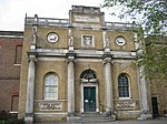 More images |
| Entrance archway and gates at Pitzhanger Manor at north-east end of park | Ealing Green | Gate | 1802 | 19 January 1981 | TQ1760080517 51°30′41″N 0°18′24″W / 51.511351°N 0.306752°W / 51.511351; -0.306752 (Entrance archway and gates at Pitzhanger Manor at north-east end of park) | 1079350 |  More images |
| Wharncliffe Viaduct | Hanwell | Viaduct | 1836–37 | 8 November 1949 | TQ1492280399 51°30′39″N 0°20′43″W / 51.510841°N 0.345364°W / 51.510841; -0.345364 (Wharncliffe Viaduct) | 1358811 |  More images |
Grade II*
| Name | Location | Type | Completed [note 1] | Date designated | Grid ref.[note 2] Geo-coordinates | Entry number [note 3] | Image |
|---|---|---|---|---|---|---|---|
| Bridge at northern end of Walpole Park | Ealing Green | Bridge | 1801–11 | 19 January 1981 | TQ1749480489 51°30′40″N 0°18′30″W / 51.511121°N 0.308289°W / 51.511121; -0.308289 (Bridge at northern end of Walpole Park) | 1079351 |  More images |
| Canteen block to Hoover Factory | Perivale | Canteen | 1938 | 7 May 1981 | TQ1661282987 51°32′02″N 0°19′13″W / 51.533755°N 0.320166°W / 51.533755; -0.320166 (Canteen block to Hoover Factory) | 1079361 | 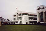 More images |
| Church of St Mary | Ealing | Church | 1739 | 19 January 1981 | TQ1769479743 51°30′16″N 0°18′20″W / 51.504375°N 0.305657°W / 51.504375; -0.305657 (Church of St Mary) | 1079376 | 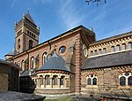 More images |
| Church of St Mary | Norwood Green | Church | 12th century | 8 November 1949 | 51°29′43″N 0°22′00″W / 51.495177°N 0.366546°W / 51.495177; -0.366546 (Church of St Mary) | 1189501 |  More images |
| Church of St Mary | Hanwell | Church | c.1841 | 24 February 1950 | TQ1476980730 51°30′50″N 0°20′51″W / 51.513847°N 0.34746°W / 51.513847; -0.34746 (Church of St Mary) | 1079453 |  More images |
| Church of St Peter | Ealing | Church | 1889–92 | 19 January 1981 | TQ1773281732 51°31′20″N 0°18′16″W / 51.522243°N 0.304446°W / 51.522243; -0.304446 (Church of St Peter) | 1079390 |  More images |
| Church of St Thomas the Apostle | Ealing | Anglican church | 1933–34 | 3 January 1996 | TQ1599379352 51°30′04″N 0°19′49″W / 51.501212°N 0.330282°W / 51.501212; -0.330282 (Church of St Thomas the Apostle) | 1244068 |  More images |
| Former Norwood Free School | Norwood Green | Free school | 1767 | 29 September 1976 | TQ1354078671 51°29′44″N 0°21′57″W / 51.495589°N 0.365825°W / 51.495589; -0.365825 (Former Norwood Free School) | 1079381 |  |
| Goldsmiths' Almshouses and railings fronting road | Ealing | Gate | 1811 | 25 January 1951 | TQ2084880401 51°30′35″N 0°15′36″W / 51.509624°N 0.260011°W / 51.509624; -0.260011 (Goldsmiths' Almshouses and railings fronting road) | 1358762 |  More images |
| Holy Cross New Church | Ealing | Church | 1939 | 19 January 1981 | TQ1449283158 51°32′09″N 0°21′02″W / 51.535725°N 0.350662°W / 51.535725; -0.350662 (Holy Cross New Church) | 1079417 | 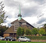 More images |
| Liberty Cinema | Ealing | Former cinema | 1928 | 18 September 1980 | TQ1277580331 51°30′38″N 0°22′35″W / 51.510662°N 0.37631°W / 51.510662; -0.37631 (Liberty Cinema) | 1079380 |  More images |
| Main front block to Hoover Factory | Perivale | Electrical goods factory | 1932–35 | 10 October 1980 | TQ1667482965 51°32′01″N 0°19′09″W / 51.533544°N 0.31928°W / 51.533544; -0.31928 (Main front block to Hoover Factory) | 1079353 | 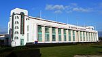 More images |
| No. 14 South Parade | Ealing | House | 1889–91 | 2 February 1970 | TQ2092778852 51°29′44″N 0°15′34″W / 51.495686°N 0.259403°W / 51.495686; -0.259403 (No. 14 South Parade) | 1294239 |  More images |
| Odeon Cinema | Ealing | Cinema | c.1932 | 16 January 1974 | TQ1706479079 51°29′55″N 0°18′54″W / 51.498538°N 0.31495°W / 51.498538; -0.31495 (Odeon Cinema) | 1079396 |  More images |
| Parish Church of Christ the Saviour | Ealing | Church | 1852 | 24 February 1950 | TQ1771780760 51°30′49″N 0°18′18″W / 51.513511°N 0.304986°W / 51.513511; -0.304986 (Parish Church of Christ the Saviour) | 1079392 |  More images |
| Roman Bridge | Ealing | Bridge | Late 18th century | 8 November 1949 | TQ1440979024 51°29′55″N 0°21′12″W / 51.498587°N 0.353199°W / 51.498587; -0.353199 (Roman Bridge) | 1079401 |  More images |
| Southall Manor House | Ealing | House | c.1821 | 8 November 1949 | TQ1247079400 51°30′08″N 0°22′52″W / 51.502355°N 0.381°W / 51.502355; -0.381 (Southall Manor House) | 1079419 |  More images |
| The Elms | Ealing | House | c.1720 | 25 January 1951 | TQ1954580329 51°30′33″N 0°16′44″W / 51.509254°N 0.278802°W / 51.509254; -0.278802 (The Elms) | 1079349 |  More images |
Notes
- ^ a b The date given is the date used by Historic England as significant for the initial building or that of an important part in the structure's description.
- ^ a b Sometimes known as OSGB36, the grid reference is based on the British national grid reference system used by the Ordnance Survey.
- ^ a b The "List Entry Number" is a unique number assigned to each listed building and scheduled monument by Historic England.
External links
 Media related to Grade I listed buildings in the London Borough of Ealing at Wikimedia Commons
- Media related to Grade II* listed buildings in the London Borough of Ealing at Wikimedia Commons
- v
- t
- e


- Ealing Central and Acton
- Ealing North
- Ealing Southall
 Acton Central
- Acton Main Line
 Acton Town
- Boston Manor
- Castle Bar Park
- Chiswick Park
- Drayton Green
- Ealing Broadway
- Ealing Common
- Greenford
- Hanger Lane
- Hanwell
- North Acton
- North Ealing
- Northfields
- Northolt
- Northolt Park
- Park Royal
- Perivale
- South Acton
- Southall
- South Ealing
- South Greenford
- Sudbury Town
- West Acton
- West Ealing

- Ealing Abbey
- Gurdwara Sri Guru Singh Sabha, Southall
- London Buddhist Vihara
- St Alban's, Acton Green
- St Anselm's, Southall
- St Gabriel's, North Acton
- St John's, Ealing
- St Mary's, Ealing
- St Mary's, Hanwell
- St Mary's, Perivale
- St Mary with St Richard, Northolt
- St Peter's, Ealing
- St Stephen's, Ealing
- St Thomas Cathedral, Acton
- St Thomas the Apostle, Hanwell
- Coat of arms
- Council
- Grade I and II* listed buildings
- People
- Public art
- Schools
 Category
- Commons

Portals:
 London
 Architecture


