Hostavice | |
|---|---|
Cadastral Area of Prague | |
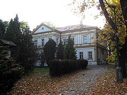 Hostavice château | |
 Location of Hostavice in Prague | |
| Coordinates: 50°5′34″N 14°33′30″E / 50.09278°N 14.55833°E | |
| Country | Czech Republic |
| Region | Prague |
| District | Prague 14 |
| Area | |
• Total | 1.98 km2 (0.76 sq mi) |
| Population (2021)[1] | |
• Total | 3,800 |
| • Density | 1,900/km2 (5,000/sq mi) |
| Time zone | UTC+1 (CET) |
| • Summer (DST) | UTC+2 (CEST) |
Hostavice became part of Prague in 1968. Now it is part of the district of Prague 9 (Prague 14) and is a cadastral area on its own.[2]
The area is 1,98 km2 and the population is 3,800 as of the 2021 census.[1]
There is château, nature park (Klánovice-Čihadla) and nature reserve (V Pískovně).
Most of inhabitants of cadastral area of Hostavice live in settlement Jahodnice.
Demographics
[edit]
|
| |||||||||||||||||||||||||||||||||||||||||||||||||||
| Source: Censuses[3][1] | ||||||||||||||||||||||||||||||||||||||||||||||||||||
Neighboring cadastral areas
[edit]References
[edit]- ^ a b c "Results of the 2021 Census - Open data". Public Database (in Czech). Czech Statistical Office. 2021-03-27.
- ^ "Marushka - Mapový aplikační server..." sgi.nahlizenidokn.cuzk.cz. Retrieved 2018-12-08.
- ^ "Historický lexikon obcí České republiky 1869–2011 – Praha" (PDF) (in Czech). Czech Statistical Office. 2015-12-21.
| Authority control databases: National |
|---|