Prague 15
Praha 15 | |
|---|---|
Municipal District of Prague Administrative District of Prague | |
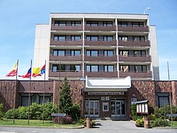 Town hall of Prague 15 (Horní Měcholupy) | |
 Flag  Coat of arms | |
 Location of Prague 15 in Prague | |
| Coordinates: 50°2′48″N 14°33′24″E / 50.04667°N 14.55667°E | |
| Country | Czech Republic |
| Region | Prague |
| Government | |
| • Mayor | Michal Fišer |
| Area | |
• Total | 10.24 km2 (3.95 sq mi) |
| Population (2021) | |
• Total | 35,167 |
| • Density | 3,400/km2 (8,900/sq mi) |
| Time zone | UTC+1 (CET) |
| • Summer (DST) | UTC+2 (CEST) |
| Postal code | 102 00, 109 00 |
| Website | http://www.praha15.cz |
Prague 15 is a municipal district (městská část) in Prague, Czech Republic. It is located in the south eastern part.
The administrative district (správní obvod) of the same name comprises municipal districts Prague 15, Horní Měcholupy, Dolní Měcholupy, Dubeč, Petrovice and Štěrboholy.
Demographics
[edit]| Year | Pop. | ±% |
|---|---|---|
| 1869 | 1,109 | — |
| 1880 | 1,274 | +14.9% |
| 1890 | 1,529 | +20.0% |
| 1900 | 1,809 | +18.3% |
| 1910 | 2,520 | +39.3% |
| 1921 | 3,375 | +33.9% |
| 1930 | 5,541 | +64.2% |
| 1950 | 6,552 | +18.2% |
| 1961 | 6,740 | +2.9% |
| 1970 | 6,917 | +2.6% |
| 1980 | 12,547 | +81.4% |
| 1991 | 27,454 | +118.8% |
| 2001 | 27,410 | −0.2% |
| 2011 | 31,296 | +14.2% |
| 2021 | 35,167 | +12.4% |
| Source: Censuses[1][2] | ||
Twin towns / sister cities
[edit] Harlow, United Kingdom (de jure district)
 Žilina, Slovakia
See also
[edit]References
[edit]- ^ "Historický lexikon obcí České republiky 1869–2011 – Praha" (in Czech). Czech Statistical Office. 2015-12-21. pp. 7–8.
- ^ "Population Census 2021: Population by sex". Public Database. Czech Statistical Office. 2021-03-27.
External links
[edit]| International | |
|---|---|
| National | |
This Prague location article is a stub. You can help Wikipedia by expanding it. |