Ilkeston North railway station
Former railway station in Derbyshire, England
Ilkeston North | |
|---|---|
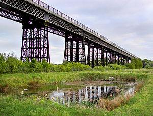 Bennerley Viaduct near Ilkeston carried the former GNR/LNER line from their Ilkeston Station to Awsworth. | |
| General information | |
| Location | Ilkeston, Erewash England |
| Grid reference | SK463427 |
| Platforms | 2 |
| Other information | |
| Status | Disused |
| History | |
| Original company | Great Northern Railway |
| Pre-grouping | Great Northern Railway |
| Post-grouping | London and North Eastern Railway London Midland Region of British Railways |
| Key dates | |
| 1 April 1878[1] | Opened as Ilkeston |
| 1 July 1950 | Renamed Ilkeston North |
| 7 September 1964 | Closed to passengers |
| 3 June 1968[2] | Goods facilities withdrawn |
Ilkeston North railway station was a railway station in Ilkeston, Derbyshire. It was opened by the Great Northern Railway on its Derbyshire Extension in 1878 and closed in 1964.
History
From Awsworth the line crossed the Erewash Valley by means of the impressive Bennerley Viaduct which has been partly preserved. It then made the climb to Ilkeston before crossing the Nut Brook towards West Hallam.[3] At Stanton Junction lines led northwards to Heanor and southwards to Stanton Ironworks. Ilkeston at one time had three stations, Ilkeston Town being on a branch leading from the Midland Railway's Erewash Valley Line at the third station, Ilkeston Junction and Cossall.
| Preceding station | Disused railways | Following station | ||
|---|---|---|---|---|
| Awsworth | London Midland Region of British Railways (Derby) Friargate Line | West Hallam | ||
| Marlpool | Heanor Branch Line Great Northern Railway | Terminus |
Present day
The station has been demolished and in the 1990 a police station and doctor's surgery and pharmacy were built on its site. Some of the remaining track bed has also been built on, with the remainder to the East forming the Cotmanhay Linear Park.[4]
References
- ^ Butt, R.V.J. (1995). The Directory of Railway Stations, Patrick Stephens Ltd, Sparkford, ISBN 1-85260-508-1, p. 126.
- ^ Clinker, C.R. (October 1978). Clinker's Register of Closed Passenger Stations and Goods Depots in England, Scotland and Wales 1830-1977. Bristol: Avon-AngliA Publications & Services. p. 67. ISBN 0-905466-19-5.
- ^ Higginson, M., (1989) The Friargate Line:Derby and the Great Northern Railway, Derby: Golden Pingle Publishing
- ^ Nottingham's Lost Railway Heritage
- v
- t
- e
Closed railway stations in Derbyshire
- Higher Buxton
- Hartington
- Alsop en le Dale
- Tissington
- Thorpe Cloud
- Ashbourne
- Clifton (Mayfield)
- Norbury and Ellaston
- Shallcross
- Ladmanlow
- Hindlow
- Dowlow Halt
- Hurdlow
- Parsley Hay
- Hopton Top Wharf
- Steeplehouse
- Cromford (C&HPR)
and Midland Jcn Rly
- Buxton (Midland)
- Peak Forest
- Millers Dale
- Monsal Dale
- Longstone
- Great Longstone for Ashford
- Hassop
- Bakewell
- Rowsley
- Ashover Butts
- Salter Lane
- Fallgate
- Milltown
- Dale Bank
- Woolley
- Hurst Lane
- Stretton
- Clay Lane
- Springfield (Derbyshire)
- Holmgate
- Chesterfield Road
- Claycross and Egstow
- Egginton Junction
- Etwall
- Mickleover
- Derby Friargate
- Breadsall
- West Hallam
- Ilkeston North
- Heanor (GNR)
- Marlpool
- Ripley
- Denby
- Kilburn
- Coxbench
- Little Eaton
- Crosshill and Codnor
- Heanor (MR)
- Langley Mill (Branch)
- Borrowash
- Draycott and Breaston
- Sawley
- Long Eaton (MCR)
- Doe Hill
- Westhouses and Blackwell
- Pye Bridge
- Codnor Park and Ironville
- Shipley Gate
- Ilkeston Town
- Ilkeston Junction and Cossall
- Trowell
- Stanton Gate
- Stapleford and Sandiacre
- Long Eaton (1847–1863)
- Long Eaton (1863–1967)
- Trent
and East Coast Railway
52°58′46″N 1°18′41″W / 52.97944°N 1.31139°W / 52.97944; -1.31139


