Iztaccihuatl
Volcano in Mexico


Iztaccíhuatl
Location in Mexico
Show map of Mexico
Iztaccíhuatl
Iztaccíhuatl (North America)
Show map of North AmericaIztaccíhuatl or Ixtaccíhuatl (both forms also spelled without the accent) (Nahuatl pronunciation: [istakˈsiwat͡ɬ] ⓘ or, as spelled with the x, [iʃtakˈsiwat͡ɬ]) is a 5,230 m (17,160 ft)[1] dormant volcanic mountain in Mexico located on the border between the State of Mexico and Puebla within Izta-Popo Zoquiapan National Park. It is the nation's third highest, after Pico de Orizaba at 5,636 m (18,491 ft), and Popocatépetl at 5,426 m (17,802 ft).
The name "Iztaccíhuatl" is Nahuatl for "White woman", reflecting the four individual snow-capped peaks which depict the head, chest, knees and feet of a sleeping female when seen from east or west. Iztaccíhuatl is to the north of its twin Popocatépetl, to which it is connected by the high altitude Paso de Cortés. Depending on atmospheric conditions Iztaccíhuatl is visible much of the year from Mexico City some 70 km (43 mi) to the northwest. The first recorded ascent was made in 1889, though archaeological evidence suggests the Mexica and previous cultures climbed it previously. It is the lowest peak containing permanent snow and glaciers in Mexico.
Geology
The summit ridge of the massive 450 km3 (110 cu mi) volcano is a series of overlapping cones constructed along a NNW-SSE line to the south of the Pleistocene Llano Grande caldera. There have been andesitic and dacitic Pleistocene and Holocene eruptions from vents at or near the summit. Areas near the El Pecho summit vent are covered in flows and tuff beds post-dating glaciation, approximately 11,000 years ago. The most recent vents are at El Pecho and a depression at 5,100 m (16,700 ft) along the summit ridge midway between El Pecho and Los Pies.[1]
Legend of Popocatépetl and Iztaccíhuatl

In Aztec mythology, Iztaccíhuatl was a princess who fell in love with one of her father's warriors, Popocatépetl. The emperor sent Popocatépetl to war in Oaxaca, promising him Iztaccíhuatl as his wife when he returned (which Iztaccíhuatl's father presumed he would not). Iztaccíhuatl was falsely told that Popocatépetl had died in battle, and believing the news, she died of grief. When Popocatépetl returned to find his love dead, he took her body to a spot outside Tenochtitlan and knelt by her grave. The gods covered them with snow and changed them into mountains. Iztaccíhuatl's mountain is called "White Woman" (from Nahuatl iztāc "white" and cihuātl "woman") because it resembles a woman lying on her back, and is often covered with snow — the peak is sometimes nicknamed La Mujer Dormida, "The Sleeping Woman". Popocatépetl became an active volcano, raining fire on Earth in blind rage at the loss of his beloved.[3]
Elevation
Iztaccihuatl is usually listed at 5,286 m (17,343 ft), but SRTM data and the Mexican national mapping survey assert that a range of 5,220 to 5,230 m (17,130 to 17,160 ft) is more accurate.[4][5] The Global Volcanism Program cites 5,230 m (17,160 ft).[1]
Gallery
-
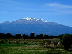 Iztaccíhuatl from the Puebla side
 -
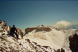 Around the Knees (5,000 m (3.1 mi)) of Iztaccíhuatl
 -
 Forest fires on the slopes
 -
 View from the ridge of Mt. Izta towards Pico de Orizaba
 -
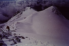 Iztaccihuatl Ridge after the mountain shelter


See also
 North America portal
 Mexico portal
 Mountains portal
 Volcanoes portal


References
- ^ a b c d e f "Iztaccíhuatl". Global Volcanism Program. Smithsonian Institution. Retrieved 2010-06-22.
- ^ "Volcán Iztaccíhuatl". Summits of the World. peakbagger.com. Retrieved 30 June 2010.
- ^ "The Legend of Popocatépetl and Iztaccíhuatl". Online guide to Mexico.
- ^ "Elevaciones principales - Puebla" (in Spanish). Instituto Nacional de Estadística, Geografía e Informática. Archived from the original on 10 March 2012. Retrieved 17 March 2009.
- ^ "Lo más y lo menos del territorio de México - Montañas (más altas)" (in Spanish). Instituto Nacional de Estadística, Geografía e Informática. Archived from the original on 3 March 2012. Retrieved 22 February 2009.
External links
Iztaccíhuatl at Wikipedia's sister projects
 Definitions from Wiktionary
 Media from Commons
 News from Wikinews
 Quotations from Wikiquote
 Texts from Wikisource
 Textbooks from Wikibooks
 Resources from Wikiversity
Descriptions
- Iztaccíhuatl - Volcano World
- Iztaccíhuatl - Ski Mountaineer
- "Iztaccihuatl". Peakware.com. Archived from the original on 2016-03-04.
Other
- Iztaccíhuatl - Stamps
- Legend of The Sleeping Lady and Smoking Mountain
- v
- t
- e
- Denali
- Mount Logan
- Pico de Orizaba
- Mount Saint Elias
- Volcán Popocatépetl
- Mount Foraker
- Mount Lucania
- Volcán Iztaccíhuatl
- King Peak
- Mount Bona
- Mount Steele
- Mount Blackburn
- Mount Sanford
- Mount Wood
- Mount Vancouver
- Mount Slaggard
- Nevado de Toluca
- Mount Fairweather
- Sierra Negra
- Mount Hubbard
- Mount Bear
- Mount Walsh
- Mount Hunter
- Volcán La Malinche
- Mount Whitney
- Mount Alverstone
- University Peak
- Mount Elbert
- Mount Massive
- Mount Harvard
- Mount Rainier
- Mount Williamson
- McArthur Peak
- Blanca Peak
- La Plata Peak
- Uncompahgre Peak
- Crestone Peak
- Mount Lincoln
- Castle Peak
- Grays Peak
- Mount Antero
- Mount Blue Sky
- Longs Peak
- Mount Wilson
- White Mountain Peak
- North Palisade
- Mount Princeton
- Mount Yale
- Mount Shasta
- Maroon Peak
- Mount Wrangell
- Mount Sneffels
- Capitol Peak
- Pikes Peak
- Windom Peak/Mount Eolus
- Mount Augusta
- Handies Peak
- Culebra Peak
- Cofre de Perote
- San Luis Peak
- Mount of the Holy Cross
- Nevado de Colima
- Grizzly Peak
- Mount Humphreys
- Mount Keith
- Mount Strickland
- Mount Ouray
- Vermilion Peak
- Avalanche Peak
- Atna Peaks
- Volcán Tajumulco
- Regal Mountain
- Mount Darwin
- Mount Hayes
- Mount Silverheels
- Rio Grande Pyramid
- Gannett Peak
- Mount Kaweah
- Grand Teton
- Mount Cook
- Mount Morgan
- Mount Gabb
- Bald Mountain
- Mount Oso
- Mount Jackson
- Mount Tom
- Bard Peak
- Cerro Tláloc
- West Spanish Peak
- Mount Powell
- Hagues Peak
- Mount Dubois
- Tower Mountain
- Treasure Mountain
- Kings Peak
- North Arapaho Peak
- Mount Pinchot
- Mount Natazhat
- Mount Jarvis
- Parry Peak
- Bill Williams Peak
- Sultan Mountain
- Mount Herard
- Volcán Tacaná
- West Buffalo Peak
- Mount Craig
- Tressider Peak
- Summit Peak
- Middle Peak/Dolores Peak
- Antora Peak
- Henry Mountain
- Hesperus Mountain
- Mount Silverthrone
- Jacque Peak
- Bennett Peak
- Wind River Peak
- Mount Waddington
- Conejos Peak
- Mount Marcus Baker
- Cloud Peak
- Wheeler Peak
- Francs Peak
- Twilight Peak
- South River Peak
- Mount Ritter
- Red Slate Mountain
Authority control databases | |
|---|---|
| International |
|
| Geographic |
|
| Other |
|


