Jericó, Antioquia
Municipality and town in Antioquia Department, Colombia

Flag
Seal
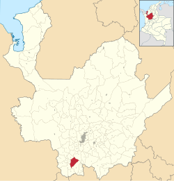
Location of the municipality and town of Jericó in the Antioquia Department of Colombia
 Colombia
 Antioquia Department
 (2015[2])
Jericó is a town, municipality and Catholic bishopric in the Colombian department of Antioquia. It is part of the subregion of Southwestern Antioquia. The distance reference from Medellín city, the capital of the department, is 104 km (64.6 miles).[3] It lies 1,910 m (6,266 ft) above sea level.
History
The town was founded on September 28, 1850, by pioneer Santiago Santamaría. It was established as municipality on 1851. During a territorial rearrangement on the country on 1908, Jericó became the capital of the homonymous department until 1911.[4]
In 2013, Jericó became the third municipality in Antioquia to be named a Pueblo Patrimonio (heritage town) of Colombia.[5]
Religion
Its Catedral de Nuestra Señora de las Mercedes, dedicated to Our Lady of Mercy, is the episcopal cathedral see of the Roman Catholic Diocese of Jericó (founded 1915, when the first cathedral was built). Due to some damages, the first church had to be replaced by the present cathedral, since 1949.[1] The town is the birthplace of Laura of Saint Catherine of Siena, canonized as saint by Pope Francis on 2013.[6]
Notable people from Jericó
- Héctor Abad Gómez
- Francisco Luis Lema
- Manuel Mejía Vallejo
- Laura of Saint Catherine of Siena
- Jesusita Vallejo
- José Restrepo Jaramillo
Sites of Interest
- Botanical Garden
- Cristo Salvador viewpoint
- Bomarzo cultural center
- Cerro Las Nubes natural reserve and viewpoint
- Casa Museo de Santa Laura
- Centro de Historia
- Museo Antropologico y de Arte (MAJA)
- Museo de Arte Religioso[7]
Sources and external links
- GCatholic - cathedral, with Google satellite picture
- GCatholic - diocese, with Google map and satellite picture
References
- ^ a b c Alcaldía de Jericó. "Nuestro Municipio: Información General" Archived 2015-12-03 at the Wayback Machine
- ^ DANE. "Resultados y proyecciones (2005-2020) del censo 2005. Retrieved on July 10, 2018.
- ^ Medellín Travel. "Medellín Travel: Jericó". Retrieved on July 11, 2018.
- ^ Marca Colombia. "Jericó: Pueblos Patrimonio de Colombia"
- ^ "GUÍA: Red Turística de Pueblos Patrimonio de Colombia" (PDF). Fondo Nacional de Turismo de la República de Colombia - FONTUR. Dec 2020. Retrieved 29 Mar 2021.
- ^ Wyss, Jim. "Madre Laura named Colombia’s first saint", The Miami Herald, Miami, May 12, 2013. Retrieved on July 10, 2018.
- ^ "Top Things to Do in Jerico, Colombia". Intentional Travelers. Retrieved 3 December 2018.
5°47′N 75°47′W / 5.783°N 75.783°W / 5.783; -75.783
- v
- t
- e
Capital: Medellín
and
municipalities
| Southwestern | |
|---|---|
| Eastern | |
| Northeastern | |
| Northern | |
| Western | |
| Bajo Cauca | |
| Magdalena Medio | |
| Urabá | |
| Metropolitan Area of the Aburrá Valley |
Authority control databases | |
|---|---|
| International |
|
| National |
|
 | This Department of Antioquia location article is a stub. You can help Wikipedia by expanding it. |
- v
- t
- e


