Jewel Cave National Monument
Cave in the Black Hills of South Dakota, USA
43°43′46″N 103°49′46″W / 43.72944°N 103.82944°W / 43.72944; -103.82944Jewel Cave National Monument contains Jewel Cave, currently the fifth longest cave in the world and second longest cave in the United States, with 219.77 miles (353.69 km) of mapped passageways as of March 2024.[3][4][5] It is located approximately 13 miles (21 km) west of the town of Custer in Black Hills of South Dakota. It became a national monument in 1908.[6]
History
Frank and Albert Michaud, two local prospectors, discovered the cave in 1900, when they felt cold air blowing out of a small hole in a canyon. It is unknown whether any previous inhabitants of the area were aware of the natural cave opening, which was not large enough for a person to enter.[7]
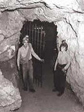
After enlarging the cave entrance with dynamite, the Michaud brothers found a cavern lined with calcite crystals, which led them to name it "Jewel Cave". The brothers tried to capitalize on the discovery, widening the opening, building walkways inside, and opening it to tourists. Although their venture was unsuccessful, news of the discovery eventually reached Washington. President Theodore Roosevelt proclaimed Jewel Cave a National Monument on February 7, 1908. The area around the natural entrance to the cave was further developed by the Civilian Conservation Corps in the 1930s. The National Park Service assumed management of the monument in 1933 and began offering tours in 1939.[7]
As recently as 1959, less than 2 miles (3.2 km) of passageway had been discovered. That year, however, Herb and Jan Conn, local rock climbers, began exploring, and within two years had mapped 15 miles (24 km). Much of the new discoveries lay outside the boundaries of the monument, under land managed by the United States Forest Service. The two agencies performed a land swap in 1965, establishing the present boundaries of the park, and enabling the development of a new part of the cave. The Park Service sunk a 300 feet (91 m) elevator shaft to a previously remote cave area, and built concrete walks and metal stairs and platforms along a one-half-mile loop. The "Scenic Tour" was opened in 1972. Most modern-day visitors tour that part of the cave. In August 2000, an 83,000 acres (340 km2) forest fire burned 90% of the monument and the surrounding area. The visitor center and historic buildings were spared.
Exploration

By 1979, Herb and Jan Conn had discovered, named, and mapped more than 64 miles (103 km) of passages. Although they largely retired from caving by the early 1980s, exploration has continued unabated. Because the areas being explored take many hours to reach, explorers now sometimes camp in the cave during expeditions of as long as four days. The cave is mapped by traditional survey techniques, using compass, clinometer and today with lasers instead of tape measures.[7]
Its near 220 mi (350 km) of mapped passageway make Jewel Cave the fifth longest cave in the world, after the Mammoth Cave System in Kentucky, Ox Bel Ha, Sac Actun, both in the Yucatán Peninsula (Mexico)[3] and Shuanghedong Cave Network in China.
The discovered areas in the cave account for only about 3–5% of the estimated total air volume of the cave, which is believed to be roughly 8 billion cubic feet (230 million cubic meters).[8] This puts estimates for the total length somewhere between roughly 4,400 miles (7,100 km) and 7,300 miles (11,700 km). The cave volume is estimated by measuring the amount of air that the cave "exhales" when the outside air pressure drops and "inhales" when the outside air pressure rises.[7]
Geology
  |
| Southwestern South Dakota |
|---|
| Sculptures |
| Geologic and natural history |
| Mountains |
| Caves |
|
| Forests and wildernesses |
| Lakes |
|
| Scenic byways |
| Historic sites |
|
|
Jewel Cave is a "breathing cave," which means air enters or exits the cave with changes in atmospheric pressure from day to night or due to changes in the weather. This was first explained by Herb Conn in 1966.[9][10]
Most of the cave formed within the Mississippian Pahasapa Limestone deposited 350 million years ago. The later limestones, sandstones, and shales deposited in these Paleozoic and Mesozoic seas were eroded with the geologic uplift associated with Laramide Orogeny and the formation of the Black Hills. The main passages of the cave then formed in the early Cenozoic. Uplift continued in the Late Pliocene or Early Pleistocene lowering the water table and draining the cave.[10]: 29–30
Jewel Cave passages follow a pattern of joint development. The faults and joints are associated with the uplift of the Black Hills approximately 58 to 54 million years ago. After main cave dissolution, a thick layer of calcite lined the walls about 2.5 million years ago.[10]: 12
During cave development and afterwards, speleothems and speleogens formed, including the "jewels" or spar. Other examples include stalactites, stalagmites, flowstone, cave popcorn, boxworks, helictites, scintillites, conulites, coralloids, cave pearls, rimstone, rafts, rims, vents, and frostwork. The gypsum formations include needles, beards, cotton, hair, flowers, and spiders. Finally, Jewel Cave contains a very rare formation called a hydromagnesite balloon. Those are created when gas of an unknown source inflates a pasty substance formed by the precipitation of the magnesium carbonate hydroxide mineral.[10]: 14–18
Jewel Cave is located less than 20 miles from Wind Cave National Park, though the caves are not believed to be connected.[11]
Access
Jewel Cave is open year-round. The Park Service offers three tours: the scenic tour, a half-mile loop through a paved and lighted central portion of the cave accessible by elevator; the historic tour, a candlelight tour through the earliest-discovered part of the cave; and a wild caving tour, through an undeveloped part of the cave near the scenic loop. There are 3 surface trails varying in length and difficulty.[7]
-
 Hydromagnesite balloon in Jewel Cave
 -
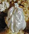
 Much of Jewel Cave is covered with spar crystals, but they are rarely as clear as this cluster.
 -
 Spar crystals cover much of the walls in some sections of the cave. Typically they are a dull brown color as in this room.
 -
 Aragonite frostwork is another speleothem found throughout the cave, typically in small crusts on the walls.
 -
 Calcite crystals in Jewel Cave


See also
- Lehman Caves
- Mammoth Cave National Park
- Oregon Caves National Monument
- Russell Cave National Monument
- Speleology
- Timpanogos Cave National Monument
- Wind Cave National Park
- List of caves
- List of longest caves
- List of national monuments of the United States
References
- ^ "Listing of acreage – December 31, 2011" (XLSX). Land Resource Division, National Park Service. Retrieved 2012-04-03. (National Park Service Acreage Reports)
- ^ "NPS Annual Recreation Visits Report". National Park Service. Retrieved 2017-10-03.
- ^ a b "Jewel Cave Cave Exploration". National Park Service (NPS). August 13, 2021. Retrieved May 22, 2022.
- ^ "Explorers return to mapping Jewel Cave after two-year hiatus". NewsCenter 1. November 5, 2021. Retrieved May 22, 2022.
- ^ "Jewel Cave Reaches 200 Miles". National Park Service (NPS). December 19, 2018. Retrieved December 19, 2018.
- ^ "The National Parks: Index 2009–2011". National Park Service. Retrieved 2012-04-02.
- ^ a b c d e Jewel Cave brochure; National Park Service; GPO, WDC
- ^ "When you explore Jewel Cave and Wind Cave in South Dakota, revelations may be around the next corner". Los Angeles Times. 2016-02-27. Retrieved 2024-01-18.
- ^ Conn, Herbert (April 1966). "Barometric Wind in Wind and Jewel Caves, South Dakota" (PDF). Bulletin of the National Speleological Society. 28 (2): 55–69.
- ^ a b c d KellerLynn, K. (2009). Jewel Cave National Monument Geologic Resources Inventory Report, National Resource Report NPS/NRPC/GRD/NRR 2009/084. US National Park.
- ^ "Esri News -- ArcNews Winter 2002/2003 Issue -- Developing a Cave Potential Map for South Dakota's Wind Cave Using GIS". www.esri.com. Retrieved 2024-01-08.
Further reading
- Conn, Herb; Conn, Jan (1977). The Jewel Cave Adventure: Fifty Miles of Discovery in South Dakota. Cave Books. ISBN 0-939748-01-0. (describes the exploration of Jewel Cave from its discovery to the mid-1980s)
- Palmer, Arthur. Jewel Cave: A gift from the past. OCLC 20543502.
- The National Parks: Index 2001–2003. Washington, D.C: U.S. Department of the Interior. OCLC 53228516.
External links
 Media related to Jewel Cave National Monument at Wikimedia Commons
 Jewel Cave National Monument travel guide from Wikivoyage
- Official website at the National Park Service
| ||
|---|---|---|
| Topics |  | |
| Lists by county |
| |
| Other lists | ||
| ||


Authority control databases | |
|---|---|
| International |
|
| National |
|
| Other |
|


