João Câmara, Rio Grande do Norte
Place in Northeast, Brazil

Flag

Seal
"Terra dos abalos" (Earthquakes land)
"Capital do mato grande" (Mato Grande's capital)
"Capital do mato grande" (Mato Grande's capital)
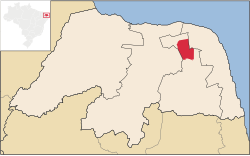
Location in Rio Grande do Norte and Brazil
(2020 [2])
João Câmara is a municipality in the state of Rio Grande do Norte, Brazil. The municipality was founded on 29 October 1928.
João Câmara borders eight municipalities, three of which are Touros to the northeast, Pureza to the east and Parazinho to the north.
References
- ^ IBGE (10 October 2002). "Área territorial oficial". Resolução da Presidência do IBGE de n° 5 (R.PR-5/02). Retrieved 5 December 2010.
- ^ IBGE 2020
- ^ "Ranking decrescente do IDH-M dos municípios do Brasil". Atlas do Desenvolvimento Humano. Programa das Nações Unidas para o Desenvolvimento (PNUD). 2010. Retrieved 4 September 2013.
| Authority control databases |
|
|---|
- v
- t
- e


