Kelleys Island State Park
Park in Ohio, USA
41°36′51″N 82°42′19″W / 41.61417°N 82.70528°W / 41.61417; -82.70528[1]
Kelleys Island State Park is a public recreation area occupying one-quarter of Kelleys Island, an island in Lake Erie located 13 miles (21 km) northeast of Port Clinton, Ohio, in the United States. The state park's 677 acres (274 ha) include six miles (9.7 km) of hiking trails, ruins of lime kilns and quarrying operations, sand beach, and campground. The park was established in 1956.[2] The park cooperates with other agencies to manage the adjoining Glacial Grooves State Memorial, a set of rare glacial grooves,[3] North Shore Alvar State Natural Area, a rare alvar habitat,[4] and the North Pond State Nature Preserve, a lake embayment usually separated from the lake by a sand bar.[5]
Gallery
-
 The famous glacial grooves of Kelleys Island.
 -
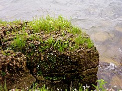 A close up of alvar in the state park.
 -
 Lakeside daises in the state park.
 -
 The park's public beach.
 -
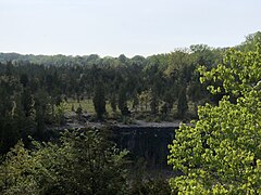 Former quarries cause dramatic cliffs like these.


References
- ^ a b "Kelleys Island State Park". Geographic Names Information System. United States Geological Survey, United States Department of the Interior.
- ^ "Kelleys Island State Park". Ohio Department of Natural Resources. Retrieved November 5, 2020.
- ^ "Glacial Grooves State Memorial". National Natural Landmarks. National Park Service. Retrieved November 5, 2020.
...very large limestone glacial grooves that measure several feet in depth.
- ^ "North Shore Alvar State Nature Preserve". Ohio Department of Natural Resources. Retrieved November 5, 2020.
- ^ "North Pond State Nature Preserve". Ohio Department of Natural Resources. Retrieved November 5, 2020.
External links
Wikimedia Commons has media related to Kelleys Island State Park.
Wikivoyage has a travel guide for Ohio State
Parks that includes
Kelleys Island State Park.
Parks that includes
Kelleys Island State Park.
- Kelleys Island State Park Ohio Department of Natural Resources
- Kelleys Island State Park Map Ohio Department of Natural Resources
- v
- t
- e
| National parks | |
|---|---|
| National historical parks and sites | |
| National monuments | |
| National memorials | |
| National trails | |
| National forests | |
| National Wild and Scenic Rivers |
|
| National Wildlife Refuges | |
| National estuarine research reserve | |
| National Natural Landmarks |
| State parks |
|
|---|---|
| State forests | |
| State nature preserves |
|
| State scenic rivers |
|
| Metro Parks |
|
|---|


