Killcare Heights, New South Wales
Suburb of Central Coast, New South Wales, Australia
| Killcare Heights Central Coast, New South Wales | |||||||||||||||
|---|---|---|---|---|---|---|---|---|---|---|---|---|---|---|---|
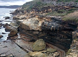 The Coast Walk in Bouddi National Park | |||||||||||||||
 | |||||||||||||||
| Population | 745 (2016 census)[1] | ||||||||||||||
| • Density | 830/km2 (2,140/sq mi) | ||||||||||||||
| Postcode(s) | 2257 | ||||||||||||||
| Elevation | 130 m (427 ft) | ||||||||||||||
| Area | 0.9 km2 (0.3 sq mi) | ||||||||||||||
| Location |
| ||||||||||||||
| LGA(s) | Central Coast Council | ||||||||||||||
| Parish | Kincumber | ||||||||||||||
| State electorate(s) | Terrigal | ||||||||||||||
| Federal division(s) | Robertson | ||||||||||||||
| |||||||||||||||
Killcare Heights is a south-eastern suburb and village located on the Bouddi Peninsula of the Central Coast region of New South Wales, Australia. It is part of the Central Coast Council local government area.
Demographics
| Country of Birth (2016)[2][3] | ||
| Birthplace[N 1] | Population | Percentage of Population |
|---|---|---|
| Australia | 594 | 79.7% |
| England | 58 | 7.8% |
| New Zealand | 13 | 1.7% |
| Germany | 11 | 1.5% |
95.3% of the population only speak English at home, with the most common languages spoken other than English being Mandarin, German and French. The median age of Killcare Heights is 47, significantly above the median age of NSW and Australia, which is 38.
41.4% of the population described themselves as without a religion; 21.1% described themselves as Catholic, and 17.1% as Anglican. Other residents have described themselves as members of the Uniting Church in Australia, Presbyterian church or Pentecostal church.
See also
Notes
References
Wikimedia Commons has media related to Marie Byles Lookout.
- ^ Australian Bureau of Statistics (27 June 2017). "Killcare Heights (State Suburb)". 2016 Census QuickStats. Retrieved 10 November 2019.

- ^ "2016 Census Community Profiles: Greater Sydney".
- ^ "2016 Census QuickStats: Killcare Heights".
33°31′55″S 151°22′05″E / 33.532°S 151.368°E / -33.532; 151.368
- v
- t
- e
Suburbs of the Central Coast, New South Wales
and localities
- Alison
- Avoca Beach
- Bar Point
- Bateau Bay
- Bensville
- Berkeley Vale
- Blackwall
- Blue Bay
- Blue Haven
- Booker Bay
- Bouddi
- Box Head
- Budgewoi
- Budgewoi Peninsula
- Buff Point
- Bushells Ridge
- Calga
- Canton Beach
- Cedar Brush Creek
- Central Mangrove
- Chain Valley Bay
- Charmhaven
- Cheero Point
- Chittaway Bay
- Chittaway Point
- Cogra Bay
- Colongra
- Copacabana
- Crangan Bay
- Daleys Point
- Davistown
- Dooralong
- Doyalson
- Doyalson North
- Durren Durren
- East Gosford
- Empire Bay
- Erina
- Erina Heights
- Ettalong Beach
- Forresters Beach
- Fountaindale
- Glenning Valley
- Glenworth Valley
- Gorokan
- Gosford
- Green Point
- Greengrove
- Gunderman
- Gwandalan
- Halekulani
- Halloran
- Hamlyn Terrace
- Hardys Bay
- Holgate
- Horsfield Bay
- Jilliby
- Kangy Angy
- Kanwal
- Kariong
- Kiar
- Killarney Vale
- Killcare
- Killcare Heights
- Kincumber
- Kincumber South
- Kingfisher Shores
- Koolewong
- Kulnura
- Lake Haven
- Lake Munmorah
- Lemon Tree
- Lisarow
- Little Jilliby
- Little Wobby
- Long Jetty
- Lower Mangrove
- MacMasters Beach
- Magenta
- Mangrove Creek
- Mangrove Mountain
- Mannering Park
- Mardi
- Marlow
- Matcham
- Moonee
- Mooney Mooney
- Mooney Mooney Creek
- Mount Elliot
- Mount White
- Narara
- Niagara Park
- Norah Head
- Noraville
- North Avoca
- North Gosford
- Ourimbah
- Palm Grove
- Palmdale
- Patonga
- Pearl Beach
- Peats Ridge
- Phegans Bay
- Picketts Valley
- Point Clare
- Point Frederick
- Pretty Beach
- Ravensdale
- Rocky Point
- San Remo
- Saratoga
- Shelly Beach
- Somersby
- Spencer
- Springfield
- St Huberts Island
- Summerland Point
- Tacoma
- Tacoma South
- Tascott
- Ten Mile Hollow
- Terrigal
- The Entrance
- The Entrance North
- Toowoon Bay
- Toukley
- Tuggerah
- Tuggerawong
- Tumbi Umbi
- Umina Beach
- Upper Mangrove
- Wadalba
- Wagstaffe
- Wallarah
- Wamberal
- Warnervale
- Watanobbi
- Wendoree Park
- West Gosford
- Wisemans Ferry
- Wondabyne
- Woongarrah
- Woy Woy
- Woy Woy Bay
- Wyee
- Wyoming
- Wyong
- Wyong Creek
- Wyongah
- Yarramalong
- Yattalunga
other waterways
points of interest
 | This Central Coast geography article is a stub. You can help Wikipedia by expanding it. |
- v
- t
- e


