Lawn, Pennsylvania
Unincorporated community in Pennsylvania, United States
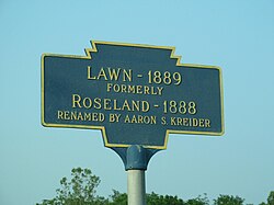
Keystone Marker
40°13′12″N 76°32′21″W / 40.22000°N 76.53917°W / 40.22000; -76.53917
17041
Lawn, previously known as Roseland, is an unincorporated community in South Londonderry Township in Lebanon County, Pennsylvania, United States. Lawn is located at the intersection of Pennsylvania Route 241 and Lawn Road.[2]
References
- ^ "Lawn". Geographic Names Information System. United States Geological Survey, United States Department of the Interior.
- ^ Lebanon County, Pennsylvania Highway Map (PDF) (Map). PennDOT. 2012. Retrieved September 3, 2013.[permanent dead link]
External links
 Media related to Lawn, Pennsylvania at Wikimedia Commons
- v
- t
- e
Municipalities and communities of Lebanon County, Pennsylvania, United States
County seat: Lebanon

communities
- Pennsylvania portal
- United States portal
 | This Lebanon County, Pennsylvania state location article is a stub. You can help Wikipedia by expanding it. |
- v
- t
- e


