Libanus, Powys
Libanus is a village in the Brecon Beacons National Park, Powys, Wales, United Kingdom, and in the community of Glyn Tarell. Presumably, the name of the village derives from Mount Lebanon, also known as the Lebanon Mountains, the ancient name for which was Libanus, a common name for chapels in Wales.
It lies on the A470 road approximately 1 mile north-east of its junction with the A4215 road, and approximately 5 miles south-west of Brecon.
The village used to have a primary school (on the right of the edge of the village going west) which was also used as a town hall but it has since been closed down due to lack of government funding and students to attend.
The Welsh language was widely used in Libanus and its surrounds until well into the 20th century.
Facilities and attractions
The village has a pub, the Tai'r Bull.
The National Park Visitor Centre (known locally as "the Mountain Centre", and sometimes as the "Brecon Beacons Mountain Centre" or "Libanus Visitor Centre") is run by the Brecon Beacons National Park Authority. It is consistently the most popular visitor attraction in the National Park.[1]
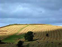
There is an Iron Age hill fort, Twyn y Gaer, in the Mynydd Illtud area just outside Libanus.
References
- ^ Libanus Visitor Centre
- v
- t
- e
Powys
- Brecon
- Builth Wells
- Crickhowell
- Hay-on-Wye
- Knighton
- Llandrindod Wells
- Llanfair Caereinion
- Llanfyllin
- Llanidloes
- Llanwrtyd Wells
- Machynlleth
- Montgomery
- Newtown
- Presteigne
- Rhayader
- Talgarth
- Welshpool
- Ystradgynlais

- Abbey Cwmhir
- Aberedw
- Aberhafesp
- Abermule with Llandyssil
- Banwy
- Bausley with Criggion
- Beguildy
- Berriew
- Bettws
- Brecon
- Bronllys
- Builth
- Cadfarch
- Caersws
- Carno
- Carreghofa
- Castle Caereinion
- Churchstoke
- Cilmery
- Clyro
- Cray
- Crickhowell
- Cwmdu and District
- Disserth and Trecoed
- Duhonw
- Dwyriw
- Erwood
- Felin-fach
- Forden with Leighton and Trelystan
- Gladestry
- Glantwymyn
- Glasbury
- Glascwm
- Glyn Tarell
- Guilsfield
- Gwernyfed
- Hay
- Honddu Isaf
- Kerry
- Knighton
- Llanafan Fawr
- Llanbadarn Fawr
- Llanbadarn Fynydd
- Llanbister
- Llanbrynmair
- Llanddew
- Llanddewi Ystradenny
- Llandinam
- Llandrindod Wells
- Llandrinio
- Llandysilio
- Llanelwedd
- Llanerfyl
- Llanfair Caereinion
- Llanfechain
- Llanfihangel
- Llanfihangel Rhydithon
- Llanfrynach
- Llanfyllin
- Llangamarch
- Llangattock
- Llangedwyn
- Llangors
- Llangunllo
- Llangurig
- Llangynidr
- Llangyniew
- Llangynog
- Llanidloes
- Llanidloes Without
- Llanigon
- Llanrhaeadr-ym-Mochnant
- Llansantffraid
- Llansilin
- Llanwddyn
- Llanwrthwl
- Llanwrtyd Wells
- Llanyre
- Llywel
- Machynlleth
- Maescar
- Manafon
- Meifod
- Merthyr Cynog
- Mochdre with Penstrowed
- Montgomery
- Nantmel
- New Radnor
- Newtown and Llanllwchaiarn
- Old Radnor
- Painscastle
- Pen-y-bont-fawr
- Penybont
- Presteigne
- Rhayader
- St Harmon
- Talgarth
- Talybont-on-Usk
- Tawe-Uchaf
- Trallong
- Trefeglwys
- Treflys
- Tregynon
- Trewern
- Vale of Grwyney
- Welshpool
- Whitton
- Yscir
- Ystradfellte
- Ystradgynlais
- Abbeycwmhir
- Aber Clydach
- Aberbechan
- Aberbran
- Abercegir
- Abercraf
- Abercynllaith
- Aberedw
- Abergwesyn
- Abergwydol
- Aberhafesp
- Aberhosan
- Abermule
- Abernant
- Abertridwr
- Aberyscir
- Adfa
- Aithnen
- Arddlin
- Bacheldre
- Beguildy
- Berriew
- Bettws Cedewain
- Beulah
- Bont Dolgadfan
- Boughrood
- Bronllys
- Builth Wells
- Burgedin
- Buttington
- Bwlch
- Caehopkin
- Caersws
- Capel-y-ffin
- Carno
- Cathedine
- Cefnllys
- Cemmaes Road
- Church Stoke
- Cilmery
- Clatter
- Clyro
- Coelbren
- Commins Coch
- Crickhowell
- Criggion
- Crossgates
- Cwmdauddwr
- Cwmdu
- Cwmtwrch
- Cwmwysg
- Cwrt-y-Gollen
- Derwenlas
- Dolanog
- Dolfach
- Dolyhir
- Dylife
- Erwood
- Esgairgeiliog
- Forge
- Four Crosses, Montgomeryshire
- Four Crosses, Llanfair Caereinion
- Gladestry
- Glasbury
- Hay-on-Wye
- Heartsease (Knighton)
- Heartsease (Llanddewi Ystradenni)
- Heol Senni
- Kerry
- Knucklas
- Libanus
- Llan
- Llanafan Fawr
- Llanbrynmair
- Llanddew
- Llandinam
- Llandrinio
- Llandysilio
- Llanelwedd
- Llanfair Caereinion
- Llanfechain
- Llanfihangel Nant Bran
- Llanfihangel Talyllyn
- Llanfyllin
- Llangadfan
- Llangammarch Wells
- Llangedwyn
- Llangors
- Llangurig
- Llangynidr
- Llangynog
- Llangynyw
- Llanllwchaiarn
- Llanrhaeadr-ym-Mochnant
- Llansantffraed
- Llansanffraid-ym-Mechain
- Llansilin
- Llanwchaiarn
- Llanwrin
- Llanwrthwl
- Llanwrtyd Wells
- Llanwrtyd
- Llanymynech
- Llanyre
- Llawryglyn
- Llyswen
- Llywel
- Meifod
- Milebrook
- Morben
- Nant Glas
- New Radnor
- Newbridge-on-Wye
- Newchurch
- Old Church Stoke
- Painscastle
- Pandy
- Pant-y-Dwr
- Partrishow
- Penegoes
- Pennant
- Penwyllt
- Penybont
- Pilleth
- Plas Esgair
- Pont Crugnant
- Pontdolgoch
- Pontrobert
- Sarn
- Sennybridge
- Soar
- St Harmon
- Staylittle
- Sycharth
- Talerddig
- Talgarth
- Talybont-on-Usk
- Three Cocks
- Tirabad
- Trecastle
- Trefeglwys
- Tregynon
- Trewern
- Tylwch
- Van, Llanidloes
- Ystradfellte
- Parliamentary constituencies
- Electoral wards
- Places
- Schools
- SSSIs
- Scheduled Monuments
- Country houses
- Listed buildings
- Registered parks and gardens
- Lord Lieutenants
- High Sheriffs
- Museums
- Public art
 Geography
 Wales
Wales


51°55′13″N 3°27′47″W / 51.92016°N 3.4631°W / 51.92016; -3.4631
 | This Powys location article is a stub. You can help Wikipedia by expanding it. |
- v
- t
- e


