Grade II* listed buildings in Powys

Map all coordinates using OpenStreetMap
Download coordinates as:
- KML
- GPX (all coordinates)
- GPX (primary coordinates)
- GPX (secondary coordinates)
In the United Kingdom, the term listed building refers to a building or other structure officially designated as being of special architectural, historical, or cultural significance; Grade II* structures are those considered to be "particularly important buildings of more than special interest".[1] Listing was begun by a provision in the Town and Country Planning Act 1947. Once listed, strict limitations are imposed on the modifications allowed to a building's structure or fittings. In Wales, the authority for listing under the Planning (Listed Buildings and Conservation Areas) Act 1990[2] rests with Cadw.
Buildings
Note: for technical reasons, the grid references in the following table are only displayed as text, not as links as in other articles in this series.
| Name | Location Grid Ref.[note 1] Geo-coordinates | Date Listed | Function | Notes | Reference Number | Image |
|---|---|---|---|---|---|---|
| Henfache | Llanrhaeadr ym Mochnant (N) SJ1238327031 52°50′01″N 3°18′07″W / 52.833670179914°N 3.3020115297021°W / 52.833670179914; -3.3020115297021 (Henfache) | 20 October 1952 | House | To the north of the farmyard of Henfache, about 1 km north of the village of Llanrhaeadr-ym-Mochnant. | 606 |  Upload Photo |
| Henblas | Llangedwyn SJ1702623809 52°48′20″N 3°13′56″W / 52.805449314517°N 3.2322902853444°W / 52.805449314517; -3.2322902853444 (Henblas) | 20 October 1952 | House | Just south of the River Tanat, about 1? km west of Pont Llangedwyn. | 607 | Upload Photo |
| Lloran Ucha | Llansilin SJ1616527140 52°50′07″N 3°14′45″W / 52.835252624503°N 3.245915344064°W / 52.835252624503; -3.245915344064 (Lloran Ucha) | 20 October 1952 | House | 608 | Upload Photo | |
| Glascoed | Llansilin SJ2177927625 52°50′26″N 3°09′46″W / 52.840457455926°N 3.1627155487148°W / 52.840457455926; -3.1627155487148 (Glascoed) | 20 October 1952 | House | At east of farmyard, about 1 km south-east of the village of Llansilin. | 610 | Upload Photo |
| Hafod | Llansilin SJ2049632163 52°52′52″N 3°10′58″W / 52.881054318976°N 3.1828674572891°W / 52.881054318976; -3.1828674572891 (Hafod) | 20 October 1952 | House | Reached by a short lane to the north of the Rhiwlas to Rhydycroesau road. | 611 | Upload Photo |
| Plas-uchaf, Llangedwyn | Llangedwyn SJ1765724533 52°48′43″N 3°13′23″W / 52.812053068195°N 3.2231149680638°W / 52.812053068195; -3.2231149680638 (Plas-uchaf, Llangedwyn) | 1 April 1966 | House | In private grounds to the north of the B4396 about 1 km west of Llangedwyn Hall. | 635 | Upload Photo |
| Church of St Dogfan, Llanrhaeadr-ym-Mochnant | Llanrhaeadr ym Mochnant SJ1239326025 52°49′29″N 3°18′06″W / 52.824630796564°N 3.3015928003855°W / 52.824630796564; -3.3015928003855 (Church of St Dogfan, Llanrhaeadr-ym-Mochnant) | 1 April 1966 | Church | In the village of Llanrhaeadr-ym-Mochnant, in a large churchyard now principally entered by a C20 lychgate at north; stone churchyard wall and railings. Gates at west and south. | 636 |  |
| Ty-newydd, Llansilin | Llansilin SJ2084727037 52°50′06″N 3°10′35″W / 52.835036410255°N 3.1764059896786°W / 52.835036410255; -3.1764059896786 (Ty-newydd, Llansilin) | 1 April 1966 | House | To east of farm buildings, 1 km south of the village of Llansilin. | 641 | Upload Photo |
| Tyddyn Cynar | Llansilin SJ2122230441 52°51′56″N 3°10′18″W / 52.865684924077°N 3.1716644134441°W / 52.865684924077; -3.1716644134441 (Tyddyn Cynar) | 1 April 1966 | House | Reached by a track to the south of the minor road from Llangadwaladr to Rhydycroesau. | 642 | Upload Photo |
| Pen-y-bryn, Llansilin | Llansilin SJ2013727063 52°50′07″N 3°11′13″W / 52.835165116093°N 3.1869492480378°W / 52.835165116093; -3.1869492480378 (Pen-y-bryn, Llansilin) | 1 April 1966 | House | To west of farm buildings, 1 km south-west of the village of Llansilin. | 655 | Upload Photo |
| Circular cow-house at Gwaunclawdd | Ystradgynlais SN8102412253 51°47′47″N 3°43′36″W / 51.796250598273°N 3.7266631839591°W / 51.796250598273; -3.7266631839591 (Circular cow-house at Gwaunclawdd) | 17 January 1963 | Cow-house | About 1km W of Abercraf; to S of A 4067 and River Tawe. Towards end of group of buildings on E side of lane. | 6610 | Upload Photo |
| Ty Mawr, Llanigon | Llanigon SO2148139958 52°03′09″N 3°08′47″W / 52.052448680832°N 3.1464895050469°W / 52.052448680832; -3.1464895050469 (Ty Mawr, Llanigon) | 19 November 1963 | House | 6612 | Upload Photo | |
| Middle Maestorglwydd Barn | Llanigon SO2140037420 52°01′47″N 3°08′50″W / 52.029623565768°N 3.1470861734794°W / 52.029623565768; -3.1470861734794 (Middle Maestorglwydd Barn) | 19 November 1963 | Barn | 6613 | Upload Photo | |
| Bronllys Castle House | Bronllys SO1490634703 52°00′15″N 3°14′28″W / 52.004241558334°N 3.2410430768789°W / 52.004241558334; -3.2410430768789 (Bronllys Castle House) | 28 September 1961 | House | Located within the inner bailey of Bronllys Castle, NNW of the motte. | 6615 | Upload Photo |
| Workshop and gallery at Bronllys Castle House | Bronllys SO1488034709 52°00′15″N 3°14′29″W / 52.004291496132°N 3.2414232346125°W / 52.004291496132; -3.2414232346125 (Workshop and gallery at Bronllys Castle House) | 28 September 1961 | Workshop | Located to the SW of Bronllys Castle House, backing on to the turn of the former inner bailey of the castle, and forming the W side of the front lawns of the house. | 6617 | Upload Photo |
| Penyrwrlodd Farmhouse | Llanigon SO2200939816 52°03′04″N 3°08′20″W / 52.051246970232°N 3.1387586739131°W / 52.051246970232; -3.1387586739131 (Penyrwrlodd Farmhouse) | 28 September 1961 | Farmhouse | 6625 | Upload Photo | |
| Tynllyne Farmhouse, Heol-y-Gaer | Llanigon SO2006439471 52°02′52″N 3°10′01″W / 52.047868196565°N 3.1670354630821°W / 52.047868196565; -3.1670354630821 (Tynllyne Farmhouse, Heol-y-Gaer) | 28 September 1961 | Farmhouse | 6628 | Upload Photo | |
| Middle Maestorglwydd House | Llanigon SO2125137209 52°01′40″N 3°08′57″W / 52.027705746773°N 3.149208881754°W / 52.027705746773; -3.149208881754 (Middle Maestorglwydd House) | 28 September 1961 | House | 6630 | Upload Photo | |
| Church of St Gwendoline, Talgarth | Talgarth SO1572833817 51°59′47″N 3°13′44″W / 51.996403279277°N 3.2288532222797°W / 51.996403279277; -3.2288532222797 (Church of St Gwendoline, Talgarth) | 28 September 1961 | Church | Situated on a small rise above the village, at the junction of Church St. with School St. | 6636 |  See more images |
| Coleg Trefeca | Talgarth SO1439832142 51°58′52″N 3°14′52″W / 51.981143613937°N 3.2478013336079°W / 51.981143613937; -3.2478013336079 (Coleg Trefeca) | 28 September 1961 | College | Former theological college, established 1768 | 6637 | 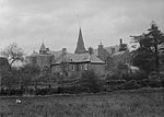 |
| Broomfield, Gwernyfed | Gwernyfed SO1841739473 52°02′52″N 3°11′28″W / 52.04764574015°N 3.1910467595369°W / 52.04764574015; -3.1910467595369 (Broomfield, Gwernyfed) | 28 September 1961 | House | Located on a terrace cut out of the steep bank of the Wye valley, high above the main Brecon to Hay road, and backing directly on to the former Hereford, Hay and Brecon Railway. | 6643 | Upload Photo |
| Garden gatepiers to a cross terrace in the formal W gardens at Old Gwernyfed | Gwernyfed SO1818436572 52°01′18″N 3°11′37″W / 52.021535187259°N 3.1937486016855°W / 52.021535187259; -3.1937486016855 (Garden gatepiers to a cross terrace in the formal W gardens at Old Gwernyfed) | 28 September 1961 | Gatepiers | Located approximately 60m W of the SW wing of the W elevation of Old Gwernyfed house, on a cross terrace of the garden earthworks, laid out SSW to NNE, tangentially to and overlooked by the house. | 6645 | Upload Photo |
| North Tower in inner front garden, with the garden boundary wall leading to the NE wing of the Old Gwernyfed house | Gwernyfed SO1828936547 52°01′17″N 3°11′32″W / 52.021325973878°N 3.1922127832949°W / 52.021325973878; -3.1922127832949 (North Tower in inner front garden, with the garden boundary wall leading to the NE wing of the Old Gwernyfed house) | 28 September 1961 | Tower | Located at the NE corner of the inner courtyard in front of Old Gwernyfed, and attached at the rear to the range of farm buildings previously belonging to Old Gwernyfed. Formerly (pre-1800) set in a garden curtain wall. | 6646 | Upload Photo |
| Y Dderw | Bronllys SO1400237657 52°01′50″N 3°15′18″W / 52.030654009669°N 3.2549519135599°W / 52.030654009669; -3.2549519135599 (Y Dderw) | 28 February 1952 | Farmhouse | Located at the head of the driveway off the main Llyswen to Hay road, on level ground in the floodplain of the River Wye. | 6650 |  |
| Trefeca College Farmhouse | Talgarth SO1445132512 51°59′04″N 3°14′50″W / 51.984477565853°N 3.2471222296162°W / 51.984477565853; -3.2471222296162 (Trefeca College Farmhouse) | 28 February 1952 | Farmhouse | 6651 |  | |
| Great Porthamel Farm | Talgarth SO1593035200 52°00′32″N 3°13′35″W / 52.008865213619°N 3.2262515576527°W / 52.008865213619; -3.2262515576527 (Great Porthamel Farm) | 28 February 1952 | Farmhouse | 6652 |  See more images | |
| Church of St Peter, The Vale of Grwyney | Llanbedr, The Vale of Grwyney SO2397020420 51°52′38″N 3°06′21″W / 51.877168307481°N 3.1058667531156°W / 51.877168307481; -3.1058667531156 (Church of St Peter, The Vale of Grwyney) | 19 July 1963 | Church | In the centre of Llanbedr village and within a walled churchyard. | 6658 |  |
| Church of St Michael, Llanfihangel Cwmdu with Bwlch and Cathedine | Llanfihangel Cwmdu with Bwlch and Cathedine SO1804923844 51°54′26″N 3°11′34″W / 51.907106011604°N 3.1926740148828°W / 51.907106011604; -3.1926740148828 (Church of St Michael, Llanfihangel Cwmdu with Bwlch and Cathedine) | 19 July 1963 | Church | Prominently sited at the N end of Cwmdu village, on E side of A479, and surrounded by churchyard. | 6668 |  |
| Church of St Cattwg, Llangattock | Llangattock SO2109117878 51°51′14″N 3°08′50″W / 51.853917337682°N 3.1470983015226°W / 51.853917337682; -3.1470983015226 (Church of St Cattwg, Llangattock) | 19 July 1963 | Church | Located at the N end of the village, 0.6km from Crickhowell Bridge. In an oval churchyard with a lych gate to the SW. | 6675 |  See more images |
| Cwrt Llangattock | Llangattock SO2097217970 51°51′17″N 3°08′56″W / 51.854727464979°N 3.1488467670098°W / 51.854727464979; -3.1488467670098 (Cwrt Llangattock) | 19 July 1963 | House | Situated on the NW edge of Llangattock village, 0.15km from the church, and on the W side of the lane leading to Dardy. | 6676 | Upload Photo |
| Plas Llangattwg | Llangattock SO2119917837 51°51′13″N 3°08′44″W / 51.853564072488°N 3.1455212155314°W / 51.853564072488; -3.1455212155314 (Plas Llangattwg) | 19 July 1963 | House | Located at the N end of the village, 0.15km from the church. The house is situated within oval-shaped gardens, the road curving round them to the SE. Ornate cast iron gates on the roadside lead to a circular driveway in front of the house. | 6677 | Upload Photo |
| Church of St Cenau, Llangenny | Llangenny, The Vale of Grwyney SO2401218148 51°51′24″N 3°06′17″W / 51.856750552027°N 3.1047561216638°W / 51.856750552027; -3.1047561216638 (Church of St Cenau, Llangenny) | 19 July 1963 | Church | On E side of a minor road through Llangenny, and W side of Afon Grwyne, in a walled churchyard. | 6680 | 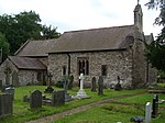 |
| Penlan | The Vale of Grwyney SO2515919840 51°52′20″N 3°05′18″W / 51.872115694354°N 3.0884721104644°W / 51.872115694354; -3.0884721104644 (Penlan) | 19 July 1963 | House | Isolated house on high ground approximately 1.3km SE of Llanbedr church, reached by private road S of minor road between Llangenny and Partrishow at Dyffryn farm. | 6683 | Upload Photo |
| Churchyard cross at Church of St Issui, Partrishow | Patrishow, The Vale of Grwyney SO2789122428 51°53′45″N 3°02′58″W / 51.895740740157°N 3.0493390231125°W / 51.895740740157; -3.0493390231125 (Churchyard cross at Church of St Issui, Partrishow) | 19 July 1963 | Churchyard Cross | On S side of church. | 6688 |  |
| Tynyllwyn | The Vale of Grwyney SO2806522358 51°53′42″N 3°02′48″W / 51.895134018077°N 3.0467961891907°W / 51.895134018077; -3.0467961891907 (Tynyllwyn) | 19 July 1963 | House | Approximately 200m SE of Partrishow church and reached by footpaths from church and on W side of a minor road to Grwyne Fawr reservoir. | 6690 |  |
| Neuadd | The Vale of Grwyney SO2805921025 51°52′59″N 3°02′48″W / 51.883150437707°N 3.0466048996087°W / 51.883150437707; -3.0466048996087 (Neuadd) | 19 July 1963 | House | Approximately 0.9km S of Partrishow church, on N side and set back above a minor road between Partrishow and Llanbedr. | 6691 | Upload Photo |
| Moor Park, The Vale of Grwyney | The Vale of Grwyney SO2370119850 51°52′19″N 3°06′35″W / 51.872007659986°N 3.1096474434147°W / 51.872007659986; -3.1096474434147 (Moor Park, The Vale of Grwyney) | 1 April 1952 | House | Set in parkland approximately 0.6km SSW of Llanbedr church, and reached by private drive W of minor road between Llanbedr and Llangenny. | 6693 | Upload Photo |
| Cefn Brith, Llangamarch | Llangamarch SN9164145367 52°05′46″N 3°35′00″W / 52.096019741557°N 3.5832218290912°W / 52.096019741557; -3.5832218290912 (Cefn Brith, Llangamarch) | 19 September 1952 | House | Situated about 2 km down lane to Tirabad from junction W of Llangammarch, down short drive on E side. | 6697 |  See more images |
| Church of St Mary, Crickadarn | Crickadarn, Erwood SO0896342228 52°04′15″N 3°19′47″W / 52.070933248055°N 3.3296005866235°W / 52.070933248055; -3.3296005866235 (Church of St Mary, Crickadarn) | 23 March 1962 | Church | Situated in the centre of Crickadarn village, on W side of village square, in circular raised churchyard. | 6707 |  See more images |
| The Neuadd, Erwood | Erwood SO0815642369 52°04′19″N 3°20′29″W / 52.072067075694°N 3.3414088104875°W / 52.072067075694; -3.3414088104875 (The Neuadd, Erwood) | 23 March 1962 | House | Situated on hillside reached up drive running W off road to Gwenddwr some 500m W of Crickadarn. | 6708 | Upload Photo |
| Aberduhonw | Duhonw SO0630350746 52°08′49″N 3°22′15″W / 52.147048066753°N 3.3707432342893°W / 52.147048066753; -3.3707432342893 (Aberduhonw) | 23 March 1962 | House | Situated on the NE side of the A470 some 1.5km E of Builth Wells. | 6710 | Upload Photo |
| Barn and attached ranges at Aberduhonw | Duhonw SO0634050722 52°08′49″N 3°22′13″W / 52.146838645117°N 3.3701960469195°W / 52.146838645117; -3.3701960469195 (Barn and attached ranges at Aberduhonw) | 23 March 1962 | Barn | Situated to the E of the house at Aberduhonw, on the A470 some 1.5km E of Builth Wells. | 6711 | Upload Photo |
| Llannerch-y-Cawr | Llanwrthwl SN9020761451 52°14′25″N 3°36′34″W / 52.240281527508°N 3.6093549352569°W / 52.240281527508; -3.6093549352569 (Llannerch-y-Cawr) | 23 March 1962 | House | To the SW of Dolymynach reservoir and reached by farm road S of the unclassified road to the Claerwen reservoir. | 6715 | Upload Photo |
| Church of St Tetta, Talybont on Usk | Llanddetty, Talybont-on-Usk SO1280820231 51°52′26″N 3°16′05″W / 51.87383287251°N 3.2679244835128°W / 51.87383287251; -3.2679244835128 (Church of St Tetta, Talybont on Usk) | 17 January 1963 | Church | In the scattered hamlet of Llanddetty, E of the canal and the valley road and close to the S bank of the River Usk; reached by a path down through the sloping churchyard from lychgate by road. | 6727 |  |
| Maes Mawr, Talybont on Usk | Talybont on Usk SO1180622543 51°53′40″N 3°16′59″W / 51.894456681034°N 3.283066929943°W / 51.894456681034; -3.283066929943 (Maes Mawr, Talybont on Usk) | 17 January 1963 | House | On low lying ground E of the Caerfanell river and on the E edge of the village of Talybont, reached off the B4558. | 6729 | Upload Photo |
| Aberllech | Maescar SN9111632816 51°58′59″N 3°35′13″W / 51.983118658096°N 3.586881637926°W / 51.983118658096; -3.586881637926 (Aberllech) | 17 January 1963 | House | Situated some 300m SE of Pentrebach on E side of road to Sennybridge | 6732 | Upload Photo |
| Llandefaelog-tre'r-graig | Felin Fach SO1264829986 51°57′41″N 3°16′22″W / 51.961491501561°N 3.2727257093961°W / 51.961491501561; -3.2727257093961 (Llandefaelog-tre'r-graig) | 17 January 1963 | House | On the N side of Llandefaelog-tre'r-graig some 1.7km S of Tredomen. | 6748 | Upload Photo |
| Abercynrig | Llanfrynach SO0693127062 51°56′03″N 3°21′18″W / 51.934280543268°N 3.3551133005771°W / 51.934280543268; -3.3551133005771 (Abercynrig) | 17 January 1963 | House | Situated down long drive running N off a minor road some 1.4 km NW of Llanfrynach. | 6753 | Upload Photo |
| Church of St Gastyn, Llangasty Tal-y-llyn | Llangasty, Llangors SO1331026133 51°55′37″N 3°15′44″W / 51.926962306314°N 3.2621208217205°W / 51.926962306314; -3.2621208217205 (Church of St Gastyn, Llangasty Tal-y-llyn) | 17 January 1963 | Church | Very near the S edge of Llangorse Lake and adjacent to the Old School. | 6755 | 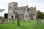 See more images |
| Old School House, Llangasty Tal-y-llyn | Llangasty, Llangors SO1329426081 51°55′35″N 3°15′44″W / 51.926492402009°N 3.2623403268831°W / 51.926492402009; -3.2623403268831 (Old School House, Llangasty Tal-y-llyn) | 17 January 1963 | House | Near Llangorse lake and adjacent to the church of St Gastyn. | 6756 |  |
| Brynllici | Llangors SO1102826353 51°55′43″N 3°17′43″W / 51.92857904609°N 3.2953551981182°W / 51.92857904609; -3.2953551981182 (Brynllici) | 17 January 1963 | House | Situated down a farm track just NW of the hamlet of Pennorth. | 6759 | Upload Photo |
| Trebinshwn house and attached stable wing | Llangors SO1364924125 51°54′32″N 3°15′24″W / 51.908965902372°N 3.2566879251258°W / 51.908965902372; -3.2566879251258 (Trebinshwn house and attached stable wing) | 17 January 1963 | House | SE of Llangorse lake, set in grounds reached by a drive. | 6760 | Upload Photo |
| Church of St Paulinus, Llangors | Llangors SO1349927626 51°56′25″N 3°15′35″W / 51.940411755156°N 3.2597488467307°W / 51.940411755156; -3.2597488467307 (Church of St Paulinus, Llangors) | 17 January 1963 | Church | Situated in the centre of Llangors Village on low lying ground in a rectangular churchyard bordered on N by Nant Cwy. | 6761 |  |
| Peterstone Court | Lanhamlach SO0880226569 51°55′49″N 3°19′40″W / 51.930159608711°N 3.3277765144809°W / 51.930159608711; -3.3277765144809 (Peterstone Court) | 17 January 1963 | Hotel | Situated down short lane running S off A40, just W of the Church of Saint Peter and Saint Illtyd in Llanhamlach. | 6762 |  |
| Cefn Brynich Canal Bridge Aqueduct | Llanfrynach SO0791327297 51°56′12″N 3°20′27″W / 51.936556460891°N 3.3408972233637°W / 51.936556460891; -3.3408972233637 (Cefn Brynich Canal Bridge Aqueduct) | 17 January 1963 | Aqueduct | Situated crossing the Usk some 180m downstream of the Lock Bridge on the road to Llanfrynach. | 6763 |  |
| Lock Road Bridge | Llanfrynach SO0773627280 51°56′11″N 3°20′36″W / 51.936374286255°N 3.3434665098648°W / 51.936374286255; -3.3434665098648 (Lock Road Bridge) | 17 January 1963 | Bridge | Situated some 200m S of the A40, carrying the road to Llanfrynach across the river Usk. | 6764 |  |
| Scethrog House | Talybont on Usk SO1067725142 51°55′03″N 3°18′01″W / 51.917637675136°N 3.3001438408669°W / 51.917637675136; -3.3001438408669 (Scethrog House) | 17 January 1963 | House | In the hamlet of Scethrog, on sloping ground above the River Usk and N of the A40. | 6767 | Upload Photo |
| Church of St Mary, Llangors | Llanywern, Llangors SO1018828663 51°56′57″N 3°18′29″W / 51.949207168904°N 3.3081720860866°W / 51.949207168904; -3.3081720860866 (Church of St Mary, Llangors) | 17 January 1963 | Church | In the centre of the small hamlet of Llanywern, on flat low land bordered by a stream to N. | 6770 |  |
| Church of Saint Cynog, Merthyr Cynog | Merthyr Cynog SN9848437443 52°01′34″N 3°28′52″W / 52.026102511688°N 3.4810083284749°W / 52.026102511688; -3.4810083284749 (Church of Saint Cynog, Merthyr Cynog) | 17 January 1963 | Church | In a prominent position in the centre of Merthyr Cynog village. | 6777 |  |
| The lodge at Penpont Manor | Trallong SN9724928585 51°56′47″N 3°29′47″W / 51.946262290025°N 3.496345274552°W / 51.946262290025; -3.496345274552 (The lodge at Penpont Manor) | 17 January 1963 | Lodge | Situated facing NE set back from drive to Penpont, about 200 m SE of the mansion. | 6780 | Upload Photo |
| The Stables, Trallong | Trallong SN9711528762 51°56′52″N 3°29′54″W / 51.947828295911°N 3.4983471608801°W / 51.947828295911; -3.4983471608801 (The Stables, Trallong) | 17 January 1963 | Stables | Situated on W side of rear court at Penpont. | 6781 | Upload Photo |
| The Old Granary and the Old Laundry | Trallong SN9712728782 51°56′53″N 3°29′53″W / 51.948010273187°N 3.4981786222189°W / 51.948010273187; -3.4981786222189 (The Old Granary and the Old Laundry) | 17 January 1963 | Granary and Laundry | Situated facing S down the rear courtyard at Penpont. | 6782 | Upload Photo |
| Dovecote at Penpont | Trallong SN9703928798 51°56′53″N 3°29′58″W / 51.948137763425°N 3.4994633142693°W / 51.948137763425; -3.4994633142693 (Dovecote at Penpont) | 17 January 1963 | Dovecote | Situated in field behind the hay-barn at Penpont. | 6784 | Upload Photo |
| Abercamlais Bridge | Trallong SN9652529064 51°57′02″N 3°30′25″W / 51.950432917438°N 3.507019223803°W / 51.950432917438; -3.507019223803 (Abercamlais Bridge) | 17 January 1963 | BRIdge | Situated to N of the yard at Abercamlais, across the Usk. | 6786 | Upload Photo |
| Pigeon house at Abercamlais | Trallong SN9645029019 51°57′00″N 3°30′29″W / 51.950014489211°N 3.5080965254819°W / 51.950014489211; -3.5080965254819 (Pigeon house at Abercamlais) | 17 January 1963 | Pigeon House | Situated W of the house at Abercamlais on a bridge over the Camlais. | 6787 | Upload Photo |
| Aberbran Fawr | Trallong SN9887928950 51°56′59″N 3°28′22″W / 51.949842087934°N 3.4727463136938°W / 51.949842087934; -3.4727463136938 (Aberbran Fawr) | 17 January 1963 | House | Some 250m S of Aberbran Bridge over the River Usk. | 6789 | Upload Photo |
| Trebarried Hall | Felin Fach SO1167735173 52°00′29″N 3°17′17″W / 52.007960807898°N 3.2881910168736°W / 52.007960807898; -3.2881910168736 (Trebarried Hall) | 25 September 1951 | House | On the E side of the A470 approximately 1km SE of the Church of Saint Matthew at Llandefalle. | 6798 | Upload Photo |
| Block of Buildings at Christ College to SE of School Chapel | Brecon SO0421928439 51°56′46″N 3°23′42″W / 51.946196161684°N 3.3949311829368°W / 51.946196161684; -3.3949311829368 (Block of Buildings at Christ College to SE of School Chapel) | 16 January 1952 | School | Within the extensive school grounds, about 200m SW of Usk Bridge. | 6827 |  |
| 1 Buckingham Place | Brecon SO0440828496 51°56′48″N 3°23′32″W / 51.946741054636°N 3.3921981686221°W / 51.946741054636; -3.3921981686221 (1 Buckingham Place) | 16 January 1952 | House | Forming the SW corner as Glamorgan Street turns N to become Wheat Street. | 6828 |  |
| Tower of Medieval Town Wall to rear of No.3 Buckingham Place | Brecon SO0442028411 51°56′46″N 3°23′31″W / 51.945979131404°N 3.391999974326°W / 51.945979131404; -3.391999974326 (Tower of Medieval Town Wall to rear of No.3 Buckingham Place) | 16 December 1976 | Town wall | Near river, to rear of No.3 Buckingham Place, Glamorgan Street; best seen from W end of Captain's Walk. | 6829 |  |
| 12 & 12a The Bulwark | Brecon SO0457628476 51°56′48″N 3°23′23″W / 51.94659°N 3.38975°W / 51.94659; -3.38975 (12 & 12a The Bulwark) | 16 January 1952 | Former houses | A three storey former townhouse, dating to the 17th century. Close to northwest end on the southern side of The Bulwark. | 6842 | Upload Photo |
| Brecon Castle Hotel | Brecon SO0428528730 51°56′56″N 3°23′39″W / 51.948823079344°N 3.3940523764161°W / 51.948823079344; -3.3940523764161 (Brecon Castle Hotel) | 16 January 1952 | Hotel | Prominently sited above River Usk and next to remains of great hall of castle. Entrance front faces Castle Square and castle motte. | 6852 |  |
| Havard House, including Forecourt Wall, Railings and Gate; and Former Stable Blocks to East and West | Brecon SO0446528460 51°56′47″N 3°23′29″W / 51.94643°N 3.39136°W / 51.94643; -3.39136 (Havard House, including Forecourt Wall, Railings and Gate; and Former Stable Blocks to East and West) | 16 January 1952 | House | Three-storey townhouse dating to the 17th century, with forecourt, railings, gate and former Stable Blocks to east and west. Between Buckingham Place and Morgannwg House. | 6893 | Upload Photo |
| 5 Glamorgan Street | Brecon SO0454128452 51°56′47″N 3°23′25″W / 51.946368459786°N 3.3902515125532°W / 51.946368459786; -3.3902515125532 (5 Glamorgan Street) | 16 January 1952 | Houses | The first houses to W of Brecknock Museum. | 6897 | Upload Photo |
| Priory Mill, Llanddew | Llanddew SO0488429639 51°57′26″N 3°23′08″W / 51.95709622675°N 3.3855916722536°W / 51.95709622675; -3.3855916722536 (Priory Mill, Llanddew) | 16 December 1976 | Mill | In the valley of the Afon Honddu below the Hay Road on the NE edge of Brecon just E of the river. | 6901 | Upload Photo |
| 46 High Street Inferior | Brecon SO0447228575 51°56′51″N 3°23′29″W / 51.947462130146°N 3.3912892971405°W / 51.947462130146; -3.3912892971405 (46 High Street Inferior) | 16 January 1952 | Shop | Set slightly forward from buildings to R. | 6933 | Upload Photo |
| Plough United Reformed Church | Brecon SO0463828496 51°56′48″N 3°23′20″W / 51.946780605169°N 3.3888529226235°W / 51.946780605169; -3.3888529226235 (Plough United Reformed Church) | 16 December 1976 | Chapel | Near S end of Lion Street, set back. | 6945 |  See more images |
| No.4 Lion Street, including Forecourt Gate & Railings | Brecon SO0460128537 51°56′50″N 3°23′22″W / 51.947142761877°N 3.3894024626529°W / 51.947142761877; -3.3894024626529 (No.4 Lion Street, including Forecourt Gate & Railings) | 16 January 1952 | House | Immediately to NW of Police Station. | 6947 |  |
| Cantre Selyf | Brecon SO0457828555 51°56′50″N 3°23′23″W / 51.947300595583°N 3.3897419925279°W / 51.947300595583; -3.3897419925279 (Cantre Selyf) | 16 January 1952 | House | To SE of junction with Lion Yard, facing lane which leads to St Mary's Church. | 6949 |  |
| Church House, Brecon | Brecon SO0451428623 51°56′52″N 3°23′26″W / 51.947900784149°N 3.390691765471°W / 51.947900784149; -3.390691765471 (Church House, Brecon) | 31 May 1961 | House | About 30m NW of entrance to Bethel Square. | 6959 | Upload Photo |
| Priory Walls at Brecon Cathedral, including North, West and Postern Gateways | Brecon SO0436229028 51°57′05″N 3°23′35″W / 51.95151480186°N 3.3930154136591°W / 51.95151480186; -3.3930154136591 (Priory Walls at Brecon Cathedral, including North, West and Postern Gateways) | 16 December 1976 | Boundary Wall | Enclosing the Cathedral Close on 3 sides. The OS map reference is to the W gateway. | 6999 |  |
| Tithe barn, Brecon Cathedral | Brecon SO0437928974 51°57′04″N 3°23′34″W / 51.951032373114°N 3.3927530887022°W / 51.951032373114; -3.3927530887022 (Tithe barn, Brecon Cathedral) | 16 January 1952 | Barn/Museum | Backing on to Priory Hill, near archway to Cathedral Close | 7001 |  See more images |
| Church of St Mary, Brecon | Brecon SO0452528525 51°56′49″N 3°23′26″W / 51.947021840966°N 3.390504521086°W / 51.947021840966; -3.390504521086 (Church of St Mary, Brecon) | 16 January 1952 | Church | Prominently sited at centre of old town. | 7015 |  |
| 5 St Mary Street | Brecon SO0445028541 51°56′50″N 3°23′30″W / 51.947152748859°N 3.3915998205264°W / 51.947152748859; -3.3915998205264 (5 St Mary Street) | 16 January 1952 | House | Immediately to S of St Mary's Church, on corner with lane to Glamorgan Street. | 7019 | Upload Photo |
| Boleyn House and Flats round Rear Courtyard and Stone Flagged Pavement | Brecon SO0437928602 51°56′52″N 3°23′34″W / 51.947688800017°N 3.392649479366°W / 51.947688800017; -3.392649479366 (Boleyn House and Flats round Rear Courtyard and Stone Flagged Pavement) | 16 December 1976 | House | Opposite Nos.8, 9, and 10, but rear courtyard approached via St Michael Street. | 7026 | Upload Photo |
| 20 Ship Street | Brecon SO0442828587 51°56′51″N 3°23′31″W / 51.947562415249°N 3.3919326070444°W / 51.947562415249; -3.3919326070444 (20 Ship Street) | 14 August 1964 | Shop | The gabled facade occupies an important position at the top of the steep hill in Ship Street | 7033 | Upload Photo |
| Rutland House, including Forecourt Wall, Piers & Iron Railings | Brecon SO0449328794 51°56′58″N 3°23′28″W / 51.949434138462°N 3.3910447769109°W / 51.949434138462; -3.3910447769109 (Rutland House, including Forecourt Wall, Piers & Iron Railings) | 16 January 1952 | House | About 30 metres N of junction with Mount Street. | 7041 | Upload Photo |
| The Elms, Brecon | Brecon SO0449828809 51°56′58″N 3°23′28″W / 51.949569820178°N 3.3909762225001°W / 51.949569820178; -3.3909762225001 (The Elms, Brecon) | 16 December 1976 | House | About 40 metres N of Mount Street. | 7042 | Upload Photo |
| Hamilton House, Brecon | Brecon SO0450028835 51°56′59″N 3°23′27″W / 51.94980385497°N 3.3909543640912°W / 51.94980385497; -3.3909543640912 (Hamilton House, Brecon) | 31 May 1961 | House | About half way along block, between Mount Street and King's Steps. | 7045 | Upload Photo |
| The County House | Brecon SO0447128791 51°56′58″N 3°23′29″W / 51.94940°N 3.39136°W / 51.94940; -3.39136 (The County House) | 16 December 1976 | House | 18th-century townhouse on west side of The Struet, almost opposite the junction with Mount Street. | 7073 |  |
| Brecknock Museum | Brecon SO0460128434 51°56′46″N 3°23′22″W / 51.946216985878°N 3.3893738460954°W / 51.946216985878; -3.3893738460954 (Brecknock Museum) | 16 January 1952 | Museum | Prominently sited at Junction of The Watton and the Bulwark. | 7116 |  |
| Bear Hotel, Crickhowell | Crickhowell SO2179718463 51°51′33″N 3°08′13″W / 51.859275540079°N 3.1369825783267°W / 51.859275540079; -3.1369825783267 (Bear Hotel, Crickhowell) | 1 April 1952 | Hotel | At the top of and facing down the High St, at an angle to the road with cobbled pavement to front. Formerly known as The White Bear | 7200 |  |
| Crickhowell Town Hall | Crickhowell SO2176318418 51°51′32″N 3°08′15″W / 51.858866254321°N 3.1374659772913°W / 51.858866254321; -3.1374659772913 (Crickhowell Town Hall) | 5 September 1983 | Market Hall | Overlooking 'The Square' near the junction with A40 | 7211 |  |
| No. 24 High Street (Latham House) | Crickhowell SO2173018352 51°51′30″N 3°08′17″W / 51.858268335514°N 3.1379300863016°W / 51.858268335514; -3.1379300863016 (No. 24 High Street (Latham House)) | 19 July 1963 | House | 7213 | Upload Photo | |
| The Dragon Hotel, Crickhowell | Crickhowell SO2177818446 51°51′33″N 3°08′14″W / 51.859120056744°N 3.1372545611822°W / 51.859120056744; -3.1372545611822 (The Dragon Hotel, Crickhowell) | 19 July 1963 | Hotel | 7218 |  | |
| St Edmunds King and Martyr Parish Church | Crickhowell SO2164618431 51°51′32″N 3°08′21″W / 51.85896666518°N 3.1391674885975°W / 51.85896666518; -3.1391674885975 (St Edmunds King and Martyr Parish Church) | 19 July 1963 | Church | 7239 |  | |
| Grahame Amey Ltd Furniture Workshop | Crickhowell SO2188218478 51°51′34″N 3°08′09″W / 51.859422305799°N 3.1357519662662°W / 51.859422305799; -3.1357519662662 (Grahame Amey Ltd Furniture Workshop) | 19 July 1963 | Workshop | 7247 | Upload Photo | |
| The Malt House, Crickhowell | Crickhowell SO2189018498 51°51′35″N 3°08′08″W / 51.859603210444°N 3.1356403518492°W / 51.859603210444; -3.1356403518492 (The Malt House, Crickhowell) | 19 July 1963 | 7248 | Upload Photo | ||
| Gazebo at the Malt House, Crickhowell | Crickhowell SO2189218520 51°51′35″N 3°08′08″W / 51.859801251793°N 3.1356162967994°W / 51.859801251793; -3.1356162967994 (Gazebo at the Malt House, Crickhowell) | 25 September 1986 | Gazebo | 7249 | Upload Photo | |
| Little Malt House, Crickhowell | Crickhowell SO2190218498 51°51′35″N 3°08′08″W / 51.859604893309°N 3.1354661376141°W / 51.859604893309; -3.1354661376141 (Little Malt House, Crickhowell) | 19 July 1963 | 7250 | Upload Photo | ||
| Upper House Farmhouse | Crickhowell SO2190818493 51°51′34″N 3°08′07″W / 51.859560788991°N 3.1353778987625°W / 51.859560788991; -3.1353778987625 (Upper House Farmhouse) | 19 July 1963 | Farmhouse | 7251 | Upload Photo | |
| Ivy Towers, Crickhowell | Crickhowell SO2175818345 51°51′30″N 3°08′15″W / 51.858209345766°N 3.1375220114115°W / 51.858209345766; -3.1375220114115 (Ivy Towers, Crickhowell) | 19 July 1963 | House | Set back from the road behind front garden with gable end to High Street beside the Dragon Hotel | 7264 |  |
| The Ivy Tower, Crickhowell | Crickhowell SO2177518347 51°51′30″N 3°08′14″W / 51.858229711909°N 3.1372756691189°W / 51.858229711909; -3.1372756691189 (The Ivy Tower, Crickhowell) | 19 July 1963 | Tower | Beside the road, in front of the Wardens Cottage and L-plan range | 7265 | Upload Photo |
| Felin Senni | Maescar SN9277823583 51°54′02″N 3°33′35″W / 51.90046161748°N 3.5598090655742°W / 51.90046161748; -3.5598090655742 (Felin Senni) | 9 May 1973 | Mill | Situated on the N side of Heol Senni down short drive off the road to Defynnog. | 7459 | Upload Photo |
| Gwernyfed High School | Aberllynfi, Gwernyfed SO1760837343 52°01′42″N 3°12′08″W / 52.028380040627°N 3.2023267375585°W / 52.028380040627; -3.2023267375585 (Gwernyfed High School) | 1 May 1976 | School | Located in former parkland, on rising ground and approached by a winding drive for approximately 300m from the entrance gates on the road. | 7464 |  |
| Trericket Mill | Bronllys SO1126941409 52°03′50″N 3°17′45″W / 52.063946823049°N 3.2957535281521°W / 52.063946823049; -3.2957535281521 (Trericket Mill) | 27 January 1984 | Mill | Situated 3.2 km N of Llyswen village, below the main road at the border between Bronllys and Erwood Communities, and Brecknock and Radnor Districts. Besides the Sgithen Brook. | 7474 |  |
| Old House at Middle Gaer | Llanfihangel Cwmdu with Bwlch and Cathedine SO1702421751 51°53′17″N 3°12′25″W / 51.888140346161°N 3.2070657053732°W / 51.888140346161; -3.2070657053732 (Old House at Middle Gaer) | 30 August 1985 | House | On S side of minor road between Middle and Lower Gaer, reached from N of A40 opposite the Kestrel Inn. | 7477 | Upload Photo |
| Penoyre House | Yscir SO0171531061 51°58′10″N 3°25′56″W / 51.969324938388°N 3.4321006981768°W / 51.969324938388; -3.4321006981768 (Penoyre House) | 31 January 1986 | House | Set high in a landscaped park (now a golf course) above the village of Cradoc to S; reached by a formal drive to E. | 7483 |  |
| Llangoed Hall | Bronllys SO1200440038 52°03′06″N 3°17′05″W / 52.051741288445°N 3.2846812080098°W / 52.051741288445; -3.2846812080098 (Llangoed Hall) | 28 September 1961 | Country house | Located on a raised terrace on the floor of the Wye valley, within its own 4 hectares grounds and formerly associated farmland, and having staff housing and stable court to the NNE, separately listed. | 7484 |  |
| Craig-y-Nos Castle | Tawe Uchaf SN8404215363 51°49′29″N 3°41′02″W / 51.824835583994°N 3.6839619571285°W / 51.824835583994; -3.6839619571285 (Craig-y-Nos Castle) | 14 March 1985 | Country House | In the upper Tawe Valley, the grounds descending to the river, with spectacular views to the surrounding mountains. | 7491 |  |
| Gileston Mill | Talybont-on-Usk SO1140122677 51°53′44″N 3°17′20″W / 51.895596790497°N 3.2889853524811°W / 51.895596790497; -3.2889853524811 (Gileston Mill) | 19 October 1989 | Mill | In the centre of Talybont Village, just N of the main street, adjacent to Afon Caerfanell, reached by a narrow lane with Talybont Farm adjacent NW. | 7500 | Upload Photo |
| Tower House, Talgarth | Talgarth SO1547233753 51°59′45″N 3°13′57″W / 51.995789024698°N 3.2325651766432°W / 51.995789024698; -3.2325651766432 (Tower House, Talgarth) | 27 March 1990 | House | Located at the corner of the Square, at the side of the A479, adjoining the bridge over the River Enig. | 7502 |  |
| Church of St Beuno, Bettws | Bettws Cedewain SO1227496826 52°33′44″N 3°17′44″W / 52.562191087958°N 3.2955639577032°W / 52.562191087958; -3.2955639577032 (Church of St Beuno, Bettws) | 3 October 1953 | Church | Located in a circular churchyard, on high ground overlooking the village of Bettws Cedewain. | 7548 |  See more images |
| Dolforgan Hall | Kerry, Powys SO1430090306 52°30′14″N 3°15′50″W / 52.5039149431°N 3.2640002682412°W / 52.5039149431; -3.2640002682412 (Dolforgan Hall) | 3 October 1953 | Hall | Located on the valley bottom at the end of a driveway leading off the main road 1km W of Kerry village, and set amid its former estate, with stable building, formal garden, and shrubbery. | 7561 | Upload Photo |
| Maesmawr Hall | Caersws SO0404891917 52°31′00″N 3°24′56″W / 52.516682426406°N 3.4154545406583°W / 52.516682426406; -3.4154545406583 (Maesmawr Hall) | 3 October 1953 | Country House | The hotel is located in the Severn valley bottom, at the end of a formal axial drive off the main Newtown to Llanidloes Road, 700m E of the junction with the A.470 to Machynlleth and level crossing. | 7572 |  See more images |
| Church of St Curig, Llangurig | Llangurig SN9078079910 52°24′23″N 3°36′25″W / 52.40628043768°N 3.6069677766876°W / 52.40628043768; -3.6069677766876 (Church of St Curig, Llangurig) | 3 October 1953 | Church | On the SW side of the village, reached from the main road and set down towards the N bank of the River Wye. | 7573 | 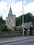 |
| Church of St Mary, Dwyriw | Llanllugan, Dwyriw SJ0577502339 52°36′38″N 3°23′35″W / 52.610648508797°N 3.3929775058373°W / 52.610648508797; -3.3929775058373 (Church of St Mary, Dwyriw) | 3 October 1953 | Church | Located in a prominent position in the small village of Llanllugan within a roughly circular churchyard. | 7579 |  |
| Church of St Gwynog, Caersws | Llanwnog, Caersws SO0222793826 52°32′01″N 3°26′34″W / 52.533514416908°N 3.4428432317877°W / 52.533514416908; -3.4428432317877 (Church of St Gwynog, Caersws) | 3 October 1953 | Church | The church is located in a raised oval churchyard at the centre of the village of Llanwnog, which was later extended to the S to border the B.4568. | 7580 |  |
| Plasau Duon | Caersws SO0025095412 52°32′51″N 3°28′21″W / 52.547408476889°N 3.4724555575966°W / 52.547408476889; -3.4724555575966 (Plasau Duon) | 3 October 1953 | Farmhouse | The farmhouse is located on a platform above the left bank of the Afon Carno, on a farm road leading off the lane from the A.470 to Bwlch-y-garreg. | 7581 |  |
| Plasnewydd | Carno SN9708996430 52°33′21″N 3°31′10″W / 52.555967459999°N 3.5193695231471°W / 52.555967459999; -3.5193695231471 (Plasnewydd) | 3 October 1953 | House | Situated on a minor road between Carno and Maesypandy, approximately 0.75km E of Carno church. The house is built on a sloping site, and faces a yard to the N flanked by C19 farm buildings, beyond which is the road. | 7583 |  |
| Ystradfaelog | Trefeglwys SN9841792474 52°31′14″N 3°29′55″W / 52.520665741549°N 3.4985774754557°W / 52.520665741549; -3.4985774754557 (Ystradfaelog) | 3 October 1953 | House | Located on the W side of a lane which runs N off the B4569 towards Clatter. | 7584 | Upload Photo |
| St Michael's Church, Manafon | Manafon SJ1131002476 52°36′46″N 3°18′41″W / 52.612813486064°N 3.3112960379305°W / 52.612813486064; -3.3112960379305 (St Michael's Church, Manafon) | 3 October 1953 | Church | The church stands centrally in the formerly oval churchyard, at the centre of the village. The churchyard, which was extended c.1926, has a lych-gate and a granite war memorial in the S corner. | 7587 |  |
| Rhyd y Carw | Trefeglwys SN9565390729 52°30′16″N 3°32′19″W / 52.504460808299°N 3.5387498070534°W / 52.504460808299; -3.5387498070534 (Rhyd y Carw) | 3 October 1953 | House | Located off the S side of the lane which runs W from Trefeglwys to Llawr y Glyn, and on the N banks of the Afon Trannon. Approx. 1.4km from Trefeglwys. | 7590 | Upload Photo |
| Talgarth | Trefeglwys SN9629690229 52°30′00″N 3°31′45″W / 52.500090361639°N 3.5291243708628°W / 52.500090361639; -3.5291243708628 (Talgarth) | 3 October 1953 | House | Located on the S side of a no-through road which runs SW from Trefeglwys following Afon Trannon. The house is on the S banks of the river, approx. 1.1 km from Trefeglwys. | 7591 |  |
| Cemmaes Bychan | Glantwymyn SH8361905959 52°38′20″N 3°43′17″W / 52.638873496278°N 3.7213138777871°W / 52.638873496278; -3.7213138777871 (Cemmaes Bychan) | 19 December 1951 | House | Located at the end of a short track off the W side of the road, close to the River Dovey. | 7597 | Upload Photo |
| Aberffrydlan | Glantwymyn SH7794602997 52°36′40″N 3°48′14″W / 52.611010309793°N 3.8040098925805°W / 52.611010309793; -3.8040098925805 (Aberffrydlan) | 19 December 1951 | House | Set down from the road close to the River Dovey, approx. 1km W of Llanwrin. | 7600 | Upload Photo |
| Abergwydol | Cadfarch SH7908902948 52°36′39″N 3°47′14″W / 52.610826182897°N 3.7871203876399°W / 52.610826182897; -3.7871203876399 (Abergwydol) | 7 February 1962 | House | Located in the Dovey valley, on the NW side of the main road, almost opposite the junction with the minor road to Abercegir. | 7604 | Upload Photo |
| Church of St Mary, Llanbrynmair | Llanbrynmair SH8841200782 52°35′36″N 3°38′56″W / 52.593361761865°N 3.6487664571837°W / 52.593361761865; -3.6487664571837 (Church of St Mary, Llanbrynmair) | 7 February 1962 | Church | Located approximately 3.2 kilometres S of Llanbrynmair on the B 4518, and set in an oval churchyard on a small hill. | 7605 |  |
| Pwlliwrch | Glantwymyn SH8367001114 52°35′43″N 3°43′08″W / 52.595348837548°N 3.7188538925932°W / 52.595348837548; -3.7188538925932 (Pwlliwrch) | 4 February 1970 | House | In a wooded upland location, approx. 1km SE of Darowen and reached by tracks running N from Tal y Wern. | 7607 | Upload Photo |
| Pen-y-Lan Hall | Meifod SJ1587012681 52°42′19″N 3°14′48″W / 52.705258230022°N 3.2465747718154°W / 52.705258230022; -3.2465747718154 (Pen-y-Lan Hall) | 31 January 1953 | House | 7609 |  | |
| Trawscoed Hall | Guilsfield SJ2102511789 52°41′53″N 3°10′12″W / 52.698019260279°N 3.1700836648285°W / 52.698019260279; -3.1700836648285 (Trawscoed Hall) | 31 January 1953 | House | 7610 | Upload Photo | |
| Llyswen | Guilsfield SJ2248213526 52°42′50″N 3°08′56″W / 52.713842003552°N 3.1489384016098°W / 52.713842003552; -3.1489384016098 (Llyswen) | 31 January 1953 | House | 7611 | Upload Photo | |
| Church of St Trunio, Llandrinio | Llandrinio SJ2955617081 52°44′48″N 3°02′42″W / 52.746763545778°N 3.0450061381799°W / 52.746763545778; -3.0450061381799 (Church of St Trunio, Llandrinio) | 31 January 1953 | Church | Situated on S side of road, at centre of village, within its large churchyard. | 7613 |  See more images |
| Llandrinio Hall | Llandrinio SJ2901117339 52°44′56″N 3°03′11″W / 52.749011010967°N 3.0531342521198°W / 52.749011010967; -3.0531342521198 (Llandrinio Hall) | 31 January 1953 | House | 7615 |  | |
| Trederwen House | Llandrinio SJ2570815786 52°44′05″N 3°06′06″W / 52.734608040937°N 3.1017058386711°W / 52.734608040937; -3.1017058386711 (Trederwen House) | 31 January 1953 | House | 7616 | Upload Photo | |
| St Garmon's Church, Llanfechain | Llanfechain SJ1889820431 52°46′31″N 3°12′13″W / 52.775374854855°N 3.2036891148615°W / 52.775374854855; -3.2036891148615 (St Garmon's Church, Llanfechain) | 31 January 1953 | Church | In a circular churchyard at the centre of the village of Llanfechain. Stone churchyard wall, lychgate at south. Sundial shaft near path to church. | 7625 |  |
| Church of St Cynyw, Llangyniew | Llangyniew SJ1271209098 52°40′21″N 3°17′32″W / 52.672555669723°N 3.2923493496655°W / 52.672555669723; -3.2923493496655 (Church of St Cynyw, Llangyniew) | 31 January 1953 | Church | In the hamlet of Llangyniew, about 4 km south-east of Pontrobert. Churchyard originally circular, extended in 1926 and defined by walls and railings. The building is oriented north-east (but conventional orientation assumed in this description). | 7633 |  |
| Church of St Ffraid, Llansanffraid-ym-Mechain | Llansantffraid SJ2204720399 52°46′32″N 3°09′25″W / 52.775551925861°N 3.1570117645967°W / 52.775551925861; -3.1570117645967 (Church of St Ffraid, Llansanffraid-ym-Mechain) | 31 January 1953 | Church | At north-east of the village, in an elevated situation; churchyard mostly stone-walled, with iron gates. Iron railings at Vicarage side. Sundial near porch. | 7638 |  See more images |
| Cefnllyfnog Farmhouse | Llansantffraid SJ1940818376 52°45′25″N 3°11′44″W / 52.756981947319°N 3.195624572498°W / 52.756981947319; -3.195624572498 (Cefnllyfnog Farmhouse) | 31 January 1953 | Farmhouse | Reached by a farm track from a minor road, about 2 km north-east of Bwlch-y-cibau. | 7643 | Upload Photo |
| Pentre'r gof | Meifod SJ1542013800 52°42′55″N 3°15′13″W / 52.715244921926°N 3.2535213766971°W / 52.715244921926; -3.2535213766971 (Pentre'r gof) | 31 January 1953 | House | 7650 | Upload Photo | |
| Plas Nant-y-Meichiaid | Meifod SJ1376516831 52°44′32″N 3°16′44″W / 52.742223810453°N 3.2788115711215°W / 52.742223810453; -3.2788115711215 (Plas Nant-y-Meichiaid) | 31 January 1953 | House | 7660 | Upload Photo | |
| John Hughes Memorial Chapel | Llangyniew SJ1093412995 52°42′26″N 3°19′11″W / 52.707289128818°N 3.3196926978898°W / 52.707289128818; -3.3196926978898 (John Hughes Memorial Chapel) | 31 January 1953 | Chapel | In a cul-de-sac lane to the north of Pontrobert Village (leading to Pentre-uchaf), on west side of lane; the chapel cemetery is on the opposite side (in different ownership). | 7661 |  |
| Church of St Michael and All Angels, Criggion | Bausley with Criggion SJ2959215119 52°43′45″N 3°02′39″W / 52.72913367657°N 3.044051336681°W / 52.72913367657; -3.044051336681 (Church of St Michael and All Angels, Criggion) | 26 October 1953 | Church | Situated at foot of N face of Breidden Hill. | 7664 | 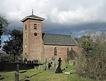 |
| Admiral Rodney's Pillar | Bausley with Criggion SJ2950714414 52°43′22″N 3°02′43″W / 52.722785991406°N 3.0451582316826°W / 52.722785991406; -3.0451582316826 (Admiral Rodney's Pillar) | 26 October 1953 | Monument | Situated at the top of Breidden Hill (365m) . | 7667 | 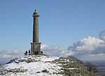 See more images |
| The Vicarage, Berriew | Berriew SJ1868400966 52°36′01″N 3°12′07″W / 52.600398200108°N 3.202045395066°W / 52.600398200108; -3.202045395066 (The Vicarage, Berriew) | 26 October 1953 | Vicarage | 7668 | Upload Photo | |
| Glansevern Hall | Berriew SO1964099999 52°35′31″N 3°11′16″W / 52.59184945691°N 3.1876985213273°W / 52.59184945691; -3.1876985213273 (Glansevern Hall) | 26 October 1953 | Hall | 7681 | 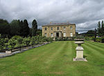 | |
| Vaynor Park | Berriew SJ1765100234 52°35′37″N 3°13′02″W / 52.593663315083°N 3.2171112184578°W / 52.593663315083; -3.2171112184578 (Vaynor Park) | 26 October 1953 | Country House | Situated in a landscaped park to the SW of Berriew village. | 7689 |  See more images |
| Cefn Bryntalch Hall | Llandyssil SO1769896320 52°33′31″N 3°12′56″W / 52.558492306524°N 3.2154440238191°W / 52.558492306524; -3.2154440238191 (Cefn Bryntalch Hall) | 26 October 1953 | House | Located in a sheltered position near the top of a wooded hill which overlooks the Severn Valley. Close to a motte and bailey castle. The house is approached by a sweeping drive and is surrounded by contemporary gardens. | 7714 |  |
| Glanhafren | Welshpool SJ2283204602 52°38′01″N 3°08′30″W / 52.633684457313°N 3.1416650637785°W / 52.633684457313; -3.1416650637785 (Glanhafren) | 3 November 1981 | House | Between the railway line and the river to the S of Welshpool, approached via a track which leaves the A490 Montgomery Road immediately W of Cilcewydd | 7730 | Upload Photo |
| Glanhafren Great Barn | Welshpool SJ2282004541 52°37′59″N 3°08′31″W / 52.633134484292°N 3.141828058246°W / 52.633134484292; -3.141828058246 (Glanhafren Great Barn) | 3 November 1981 | Barn | S of the house at Glanhafren, and approached via a track which leaves the A490 Montgomery Road immediately W of Cilcewydd Bridge. | 7733 | Upload Photo |
| Llanerchydol Hall | Welshpool SJ2044707571 52°39′36″N 3°10′39″W / 52.660024203669°N 3.1776144008473°W / 52.660024203669; -3.1776144008473 (Llanerchydol Hall) | 25 April 1950 | Country House | In parkland between the Llanfair and Llanfyllin Roads to the W of Welshpool. | 7736 |  |
| Christ Church, Welshpool | Welshpool SJ2212507489 52°39′34″N 3°09′10″W / 52.659531262505°N 3.1527916678791°W / 52.659531262505; -3.1527916678791 (Christ Church, Welshpool) | 25 April 1950 | Church | On the edge of Powis Castle Park, prominently sited above the town. | 7778 |  See more images |
| 5&6 High Street | Welshpool SJ2235207595 52°39′38″N 3°08′58″W / 52.660516592444°N 3.1494612992758°W / 52.660516592444; -3.1494612992758 (5&6 High Street) | 3 November 1981 | Shop | On the E corner with Park Lane. | 7791 | Upload Photo |
| Trefnant Hall | Castle Caereinion SJ1843203926 52°37′37″N 3°12′23″W / 52.626964091595°N 3.2064965077027°W / 52.626964091595; -3.2064965077027 (Trefnant Hall) | 25 April 1950 | Farmhouse | The farm is located on a raised plateau approximately 200m N of the lane leading SW from Welshpool. | 7864 | Upload Photo |
| Llanerch Brochwell | Guilsfield SJ1912010211 52°41′01″N 3°11′52″W / 52.683555007109°N 3.1978781448826°W / 52.683555007109; -3.1978781448826 (Llanerch Brochwell) | 3 November 1981 | House | 7879 | Upload Photo | |
| Lower Garth | Guilsfield SJ2176410155 52°41′00″N 3°09′32″W / 52.683440707983°N 3.1587616810739°W / 52.683440707983; -3.1587616810739 (Lower Garth) | 25 April 1950 | House | 7880 | Upload Photo | |
| Trewern House | Trewern SJ2833911533 52°41′48″N 3°03′43″W / 52.696737663832°N 3.0618193440015°W / 52.696737663832; -3.0618193440015 (Trewern House) | 3 November 1981 | House | 7917 | Upload Photo | |
| Trewern Hall | Trewern SJ2680711409 52°41′44″N 3°05′04″W / 52.695417840885°N 3.0844565445414°W / 52.695417840885; -3.0844565445414 (Trewern Hall) | 25 April 1950 | Hall | 7920 | Upload Photo | |
| Bronwylfa | Montgomery SO2227996435 52°33′37″N 3°08′52″W / 52.560200741974°N 3.1479135086924°W / 52.560200741974; -3.1479135086924 (Bronwylfa) | 30 March 1983 | House | Situated to right of Cullen House, the National Westminster Bank. | 7943 |  |
| Clawdd-y-dre | Montgomery SO2237896398 52°33′36″N 3°08′47″W / 52.559882342968°N 3.1464447874638°W / 52.559882342968; -3.1464447874638 (Clawdd-y-dre) | 19 July 1950 | House | Situated facing W down Lions Bank with grounds in angle of former town walls. | 7969 | Upload Photo |
| Montgomery Town Hall | Montgomery SO2221496451 52°33′37″N 3°08′56″W / 52.560335244864°N 3.1488758841588°W / 52.560335244864; -3.1488758841588 (Montgomery Town Hall) | 19 July 1950 | Town Hall | Situated in centre of Montgomery, facing E down Broad Street. | 7974 |  See more images |
| Rock House, Montgomery | Montgomery, Powys SO2218496454 52°33′37″N 3°08′58″W / 52.560357911487°N 3.1493190291205°W / 52.560357911487; -3.1493190291205 (Rock House, Montgomery) | 19 July 1950 | House | Situated prominently facing E over the Market Square. | 7975 |  |
| Newtown Baptist Church | Newtown and Llanllwchaiarn SO1092191432 52°30′49″N 3°18′51″W / 52.513492352916°N 3.3140689424756°W / 52.513492352916; -3.3140689424756 (Newtown Baptist Church) | 5 September 1988 | Church | Prominently sited at the corner of New Church Street with New Road. | 8144 |  See more images |
| Tomb of Robert Owen | Newtown and Llanllwchaiarn SO1089891800 52°31′00″N 3°18′52″W / 52.51679599527°N 3.3145064939727°W / 52.51679599527; -3.3145064939727 (Tomb of Robert Owen) | 5 September 1988 | Grave | Set against the south side of the former Parish Church. | 8154 |  |
| Penarth House | Newtown and Llanllwchaiarn SO1392892455 52°31′23″N 3°16′12″W / 52.523170772902°N 3.2700361723656°W / 52.523170772902; -3.2700361723656 (Penarth House) | 18 July 1949 | House | Stands in its own grounds 3/4 mile SW of the junction of Pool Road with the B4389 | 8217 |  |
| Sion United Reformed Church, Llanidloes (now Trinity Church) | Llanidloes SN9535084601 52°26′58″N 3°32′29″W / 52.449332200857°N 3.5412858769642°W / 52.449332200857; -3.5412858769642 (Sion United Reformed Church, Llanidloes (now Trinity Church)) | 4 October 1989 | Church | Short Bridge Street | 8371 |  |
| Dol-Llys Hall | Llanidloes SN9595785722 52°27′34″N 3°31′58″W / 52.4595225154°N 3.5327076243472°W / 52.4595225154; -3.5327076243472 (Dol-Llys Hall) | 3 October 1953 | House | Reached from the by-road that branches NE off the Trefeglwys road (B 4569) about 1 mile from the town; short straight drive up to the house which is set in extensive wooded grounds with lake. | 8388 |  |
| The Court House, 104-106 Heol Maengwyn | Machynlleth SH7500400825 52°35′27″N 3°50′48″W / 52.59082°N 3.84661°W / 52.59082; -3.84661 (The Court House, 104-106 Heol Maengwyn) | 19 January 1952 | House | At the east end of the street; detached to left | / 8460 8459 / 8460 |  |
| Royal House, Machynlleth | Machynlleth SH7454300854 52°35′28″N 3°51′12″W / 52.590978441335°N 3.8534260603003°W / 52.590978441335; -3.8534260603003 (Royal House, Machynlleth) | 19 January 1952 | Shop | In the centre of the town, on the corner of Penrallt and Garsiwn. | 8469 | 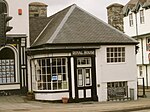 |
| Plas Machynlleth | Machynlleth SH7455800555 52°35′18″N 3°51′11″W / 52.588295375546°N 3.8530913767282°W / 52.588295375546; -3.8530913767282 (Plas Machynlleth) | 16 February 1990 | Country House | To S of the town centre. Set in its own grounds. | 8499 |  |
| Llynlloedd | Machynlleth SH7503100282 52°35′09″N 3°50′46″W / 52.585951608298°N 3.8460102425515°W / 52.585951608298; -3.8460102425515 (Llynlloedd) | 19 January 1952 | House | 8504 | Upload Photo | |
| Pont-ar-Dyfi | Machynlleth SH7441901902 52°36′01″N 3°51′20″W / 52.600366°N 3.855653°W / 52.600366; -3.855653 (Pont-ar-Dyfi) | 19 January 1952 | Bridge | Spanning the River Dyfi to N of the town, linking Powys with Gwynedd, Montgomeryshire with Meirioneth. | 8506 |  |
| Council house, Llanfyllin | Llanfyllin SJ1414219528 52°45′59″N 3°16′26″W / 52.766522684697°N 3.2739358749771°W / 52.766522684697; -3.2739358749771 (Council house, Llanfyllin) | 25 October 1951 | 8574 | Upload Photo | ||
| Llanfyllin Manor House | Llanfyllin SJ1412119452 52°45′57″N 3°16′27″W / 52.765836306477°N 3.274227083379°W / 52.765836306477; -3.274227083379 (Llanfyllin Manor House) | 25 October 1951 | Manor House | On S corner of Square and Narrow Street. | 8624 | Upload Photo |
| Cruck barn at Rhosfawr | Llanfyllin SJ0967221634 52°47′05″N 3°20′27″W / 52.784718996016°N 3.3407475621044°W / 52.784718996016; -3.3407475621044 (Cruck barn at Rhosfawr) | 22 March 1993 | Barn | 8641 | Upload Photo | |
| Ty Mawr, Trefeglwys | Trefeglwys SN9572289905 52°29′49″N 3°32′15″W / 52.49706901618°N 3.5374752002456°W / 52.49706901618; -3.5374752002456 (Ty Mawr, Trefeglwys) | 2 December 1974 | House | Located at the end of a track off a no-through road which follows the Nant y Bachws, a tributary of Afon Trannon. On low-lying ground and approx. 1.8km SW of Trefeglwys. | 8646 | Upload Photo |
| Friends' Meeting House, Dolobran | Meifod SJ1237012420 52°42′08″N 3°17′54″W / 52.702356253659°N 3.2982912837403°W / 52.702356253659; -3.2982912837403 (Friends' Meeting House, Dolobran) | 21 November 1974 | Meeting House | 8649 | Upload Photo | |
| Garth-fawr | Llangyniew SJ1170913115 52°42′31″N 3°18′30″W / 52.70849480212°N 3.3082575969989°W / 52.70849480212; -3.3082575969989 (Garth-fawr) | 10 December 1978 | House | Reached by a lane east of a minor road to the north-east of the village of Pontrobert. | 8658 | Upload Photo |
| Poultry House | Forden SJ2486904101 52°37′46″N 3°06′41″W / 52.629467818949°N 3.1114586914641°W / 52.629467818949; -3.1114586914641 (Poultry House) | 24 December 1982 | House | Approximately 0.9m SE of Leighton Hall and reached from a minor road E of B4388 from which a short private road leads through a forestry plantation to the cottage and Poultry House. | 8667 | 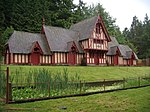 |
| Church of the Holy Trinity, Leighton | Leighton, Forden SJ2426805959 52°38′46″N 3°07′15″W / 52.646083814386°N 3.1207631465146°W / 52.646083814386; -3.1207631465146 (Church of the Holy Trinity, Leighton) | 24 December 1982 | Church | Prominently sited on E side of the Severn valley, beside a minor road on E side of B4388, and at N entrance to Leighton Farm. The church is sited within a walled churchyard. | 8668 |  |
| Piggery and Sheep Shed, Leighton Farm | Forden SJ2425705285 52°38′24″N 3°07′15″W / 52.640024380581°N 3.1207707796659°W / 52.640024380581; -3.1207707796659 (Piggery and Sheep Shed, Leighton Farm) | 24 December 1982 | Piggery | Situated at the N end of Leighton Farm. | 8670 |  See more images |
| Fodder Storage Building N of former Root Shed, Leighton Farm | Forden SJ2430105256 52°38′23″N 3°07′12″W / 52.639769881181°N 3.1201140221675°W / 52.639769881181; -3.1201140221675 (Fodder Storage Building N of former Root Shed, Leighton Farm) | 24 December 1982 | Barn | Situated on the E side of Leighton Farm with the former Root Shed to S and minor road to E. | 8671 | Upload Photo |
| Fodder Storage Building NE of former Root Shed, Leighton Farm | Forden SJ2434505254 52°38′23″N 3°07′10″W / 52.639758053661°N 3.1194634695511°W / 52.639758053661; -3.1194634695511 (Fodder Storage Building NE of former Root Shed, Leighton Farm) | 24 December 1982 | Barn | Situated on the E side of a minor road through Leighton Farm. The remaining group of farm buildings are on the opposite side of the road. | 8672 | Upload Photo |
| Former Root Shed, Leighton Farm | Forden SJ2430405230 52°38′22″N 3°07′12″W / 52.63953661296°N 3.1200637266188°W / 52.63953661296; -3.1200637266188 (Former Root Shed, Leighton Farm) | 24 December 1982 | Root Shed | Situated at the SE corner of Leighton Farm and at the corner of a junction of minor roads through Leighton. The former Root Shed has a brick wall with stone coping on its east side. | 8673 |  See more images |
| Gwernfyda | Dwyriw SJ0449601754 52°36′19″N 3°24′42″W / 52.605167314472°N 3.4116907759285°W / 52.605167314472; -3.4116907759285 (Gwernfyda) | 5 September 1985 | House | Located approximately 1.5km SW of Llanllugan, on a lane which links Cefn Coch with Adfa. The house is situated on a probable platform site at the bottom of a hillside, and faces SE. | 8679 | Upload Photo |
| Ffinnant Farmhouse | Llansantffraid SJ2079721119 52°46′55″N 3°10′33″W / 52.781840742902°N 3.1757118310294°W / 52.781840742902; -3.1757118310294 (Ffinnant Farmhouse) | 2 March 1992 | Farmhouse | At the boundary between Llansantffraid and Llanfechain Communities. Reached along farm lane off N side of B4393, beside Foel Hill, approximately 1km W of Llansantffraid-ym-Mechain. Faces N across farmyard towards barn. | 8703 | Upload Photo |
| Neuadd Cynhinfa | Llangyniew SJ0867712402 52°42′06″N 3°21′11″W / 52.701583005003°N 3.3529232550003°W / 52.701583005003; -3.3529232550003 (Neuadd Cynhinfa) | 21 September 1992 | House | Situated on a broad upland site approximately 3km SE of Dolanog; reached from a lane NE off the B4382. Farmyard ranges to E; cobbled forecourt with well. | 8709 | Upload Photo |
| Bryngwyn Hall | Meifod SJ1782918123 52°45′16″N 3°13′08″W / 52.754469842334°N 3.2189523515773°W / 52.754469842334; -3.2189523515773 (Bryngwyn Hall) | 17 January 1979 | House | 8710 | Upload Photo | |
| Slurry Tank, Forden | Forden SJ2496205451 52°38′30″N 3°06′37″W / 52.641614533578°N 3.1103922159206°W / 52.641614533578; -3.1103922159206 (Slurry Tank, Forden) | 7 February 1993 | Slurry Tank | Situated at the top of Moel y Mab approximately 0.9km SE of Leighton church and reached by private road W of a minor road between Leighton and Trelystan. | 8715 |  |
| Cwmhir Abbey | Abbeycwmhir SO0558171106 52°19′48″N 3°23′13″W / 52.329914222705°N 3.3869861825952°W / 52.329914222705; -3.3869861825952 (Cwmhir Abbey) | 12 December 1952 | Abbey (ruined) | In a field approximately 250m SSE of the parish church and on the N side of the Clywedog Brook. | 8717 | 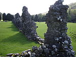 |
| Ty Faenor, Abbey Cwmhir | Abbeycwmhir SO0714771092 52°19′48″N 3°21′50″W / 52.33005614133°N 3.3640090612296°W / 52.33005614133; -3.3640090612296 (Ty Faenor, Abbey Cwmhir) | 12 December 1952 | House | On the E side of a minor road between Abbey Cwmhir and Llananno, approximately 1.7km E of the parish church. | 8718 | Upload Photo |
| Church of St Padarn, Llanbadarn Fawr | Llanbadarn Fawr SO0869864302 52°16′09″N 3°20′22″W / 52.269290028846°N 3.3394124276767°W / 52.269290028846; -3.3394124276767 (Church of St Padarn, Llanbadarn Fawr) | 12 December 1952 | Church | In a churchyard on the W side of the road approximately 0.6km S of the main road junction in Crossgates. | 8720 |  |
| Church of St Michael, Llanyre | Llanyre SO0457264388 52°16′10″N 3°24′00″W / 52.269361103706°N 3.3998821715499°W / 52.269361103706; -3.3998821715499 (Church of St Michael, Llanyre) | 12 December 1952 | Church | In a round churchyard on the E side of a minor road approximately 2km N of Llanyre. | 8721 |  |
| Barn at Cefn Ceido Farm | Nantmel SN9836068212 52°18′09″N 3°29′31″W / 52.3026129254°N 3.4920383897087°W / 52.3026129254; -3.4920383897087 (Barn at Cefn Ceido Farm) | 12 December 1952 | Barn | On the SW side of the farmhouse. | 8726 | Upload Photo |
| Gilfach farmhouse including attached former cow house | St Harmon SN9649171711 52°20′01″N 3°31′14″W / 52.333708811099°N 3.520515789127°W / 52.333708811099; -3.520515789127 (Gilfach farmhouse including attached former cow house) | 6 January 1972 | Farmhouse | Approximately 2.5km WSW of St Harmon, reached by private road on the S side of a minor road between St Harmon and Pont Marteg. | 8732 | Upload Photo |
| Church of St Michael, Bryngwyn | Bryngwyn, Painscastle SO1866649488 52°08′16″N 3°11′23″W / 52.137703260542°N 3.1898097766101°W / 52.137703260542; -3.1898097766101 (Church of St Michael, Bryngwyn) | 18 September 1960 | Church | Elevated site, sub-circular churchyard, reached along by-road running N from Rhosgoch | 8736 |  See more images |
| Ashbrook House | Clyro SO2145143859 52°05′15″N 3°08′52″W / 52.087509612161°N 3.1478259795115°W / 52.087509612161; -3.1478259795115 (Ashbrook House) | 18 September 1962 | House | House built circa 1852, listed for its associations to the Rev Francis Kilvert. | 8740 |  |
| Barn at Old Vicarage (including attached granary and stores) | Glasbury SO1773739045 52°02′37″N 3°12′03″W / 52.043697907233°N 3.2008569049183°W / 52.043697907233; -3.2008569049183 (Barn at Old Vicarage (including attached granary and stores)) | 18 September 1960 | Barn | The barn is located immediately NE of the Old Vicarage, with a forecourt to the end of the lane, all within the bend of the River Wye. | 8755 | Upload Photo |
| Church of St Peter, Llanbedr Painscastle | Llanbedr, Painscastle SO1414446395 52°06′33″N 3°15′18″W / 52.109216852529°N 3.2550835089474°W / 52.109216852529; -3.2550835089474 (Church of St Peter, Llanbedr Painscastle) | 18 September 1960 | Church | 8760 | 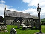 See more images | |
| Church of St Teilo, Llandeilo Graban | Llandeilo Graban, Painscastle SO0937144689 52°05′35″N 3°19′27″W / 52.093120134547°N 3.3243045420561°W / 52.093120134547; -3.3243045420561 (Church of St Teilo, Llandeilo Graban) | 18 September 1960 | Church | At the N side of a banked circular churchyard high above the River Wye | 8767 |  See more images |
| Penisarplwyf, Llandeilo Graban | Llandeilo Graban, Painscastle SO1182044111 52°05′18″N 3°17′18″W / 52.088321333072°N 3.2884174115689°W / 52.088321333072; -3.2884174115689 (Penisarplwyf, Llandeilo Graban) | 18 September 1960 | House | 8769 | Upload Photo | |
| Church of St David, Colva | Colva, Gladestry SO1996953132 52°10′14″N 3°10′18″W / 52.170648237914°N 3.1716355697626°W / 52.170648237914; -3.1716355697626 (Church of St David, Colva) | 21 September 1962 | Church | The church is set into the hill slope above the by-road from Gladestry to Glascwm. | 8773 |  |
| Stone House, Gladestry | Gladestry SO2361154498 52°11′00″N 3°07′07″W / 52.18344396423°N 3.1187015859225°W / 52.18344396423; -3.1187015859225 (Stone House, Gladestry) | 21 September 1962 | House | 8777 |  | |
| Baynham Hall | Gladestry SO2319751298 52°09′17″N 3°07′27″W / 52.154622555982°N 3.1240302453598°W / 52.154622555982; -3.1240302453598 (Baynham Hall) | 21 September 1962 | Hall | 8783 | Upload Photo | |
| Church of Michael and All Angels, Beguildy | Beguildy SO1944379732 52°24′35″N 3°11′08″W / 52.409660866428°N 3.1856934134686°W / 52.409660866428; -3.1856934134686 (Church of Michael and All Angels, Beguildy) | 24 October 1951 | Church | Within a churchyard on the W side and set above the B4355, entered from a lane on the S side. | 8791 |  |
| Llanddewi Hall | Llanddewi Ystradenny SO1084968717 52°18′34″N 3°18′33″W / 52.309325168874°N 3.3090691249607°W / 52.309325168874; -3.3090691249607 (Llanddewi Hall) | 24 October 1951 | Hall | Set back on the E side of the road through the village approximately 100m NNE of the parish church. | 8796 | Upload Photo |
| Lawn Farm, Beguildy | Beguildy SO2063976386 52°22′47″N 3°10′02″W / 52.37976144802°N 3.1673210530044°W / 52.37976144802; -3.1673210530044 (Lawn Farm, Beguildy) | 29 May 1968 | Farmhouse | Approximately 3.5km SSE of Beguildy, on the N side of a minor road on the W side of the B4355. | 8798 | Upload Photo |
| Far Hall, Llanddewi Ystradenny | Llanddewi Ystradenny SO1444968617 52°18′32″N 3°15′23″W / 52.309000139365°N 3.2562539410772°W / 52.309000139365; -3.2562539410772 (Far Hall, Llanddewi Ystradenny) | 20 April 1972 | House | Approximately 1.6km NNE of Dolau hamlet, reached from the S by a farm road through Tregrugyn Farm. | 8801 | Upload Photo |
| Church of St Cewydd, Aberedw | Aberedw SO0802647316 52°06′59″N 3°20′41″W / 52.116509393903°N 3.3446415154053°W / 52.116509393903; -3.3446415154053 (Church of St Cewydd, Aberedw) | 31 May 1962 | Church | Within a churchyard on the S side of the road through the village and on the N side of the River Edw. | 8803 |  |
| Church of St David, Cregrina | Cregrina, Glascwm SO1236552100 52°09′37″N 3°16′57″W / 52.160215103163°N 3.2825256205376°W / 52.160215103163; -3.2825256205376 (Church of St David, Cregrina) | 31 May 1962 | Church | In a churchyard above and on the W side of the main road through the hamlet. Not to be confused with the grade I listed St David's church at nearby Glascwm. | 8805 |  See more images |
| Cefndyrys | Llanelwedd SO0394452968 52°10′00″N 3°24′21″W / 52.166612811685°N 3.4058366639603°W / 52.166612811685; -3.4058366639603 (Cefndyrys) | 31 May 1962 | House | In its own grounds on the W side of the A483, overlooking Builth Wells approximately 2km to the S. | 8808 | Upload Photo |
| The Old Mill, Glascwm | Glascwm SO1137954567 52°10′56″N 3°17′51″W / 52.182231073834°N 3.2975807753431°W / 52.182231073834; -3.2975807753431 (The Old Mill, Glascwm) | 31 May 1962 | Mill | Set back on the E side of the road approximately 100m N of Hundred House Inn. | 8811 | Upload Photo |
| Old Rectory, Presteigne | Presteigne SO3151964514 52°16′28″N 3°00′18″W / 52.274517841165°N 3.0050898881509°W / 52.274517841165; -3.0050898881509 (Old Rectory, Presteigne) | 28 November 1950 | House | 8825 | Upload Photo | |
| Presteigne Shire Hall including branch library and museum | Presteigne SO3151064437 52°16′26″N 3°00′19″W / 52.273824574289°N 3.005206108144°W / 52.273824574289; -3.005206108144 (Presteigne Shire Hall including branch library and museum) | 28 November 1950 | Museum | Wide neo-classical public building set into slope. | 8845 | 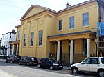 |
| Radnorshire Arms | Presteigne SO3128264545 52°16′29″N 3°00′31″W / 52.274766864328°N 3.0085691269469°W / 52.274766864328; -3.0085691269469 (Radnorshire Arms) | 28 November 1950 | Public House | 8888 |  | |
| Presteigne Manor House | Presteigne SO3136464584 52°16′30″N 3°00′27″W / 52.27512769422°N 3.0073754722765°W / 52.27512769422; -3.0073754722765 (Presteigne Manor House) | 26 March 1985 | Rectory | St David's Street | 8912 | 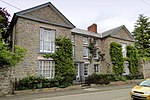 |
| Upper Dolley House | Dolley Green, Presteigne SO2845665415 52°16′56″N 3°03′01″W / 52.282225859695°N 3.050164984848°W / 52.282225859695; -3.050164984848 (Upper Dolley House) | 25 May 1972 | House | 8935 |  | |
| Old Impton Farmhouse, Norton | Presteigne SO2920267046 52°17′49″N 3°02′22″W / 52.296983313211°N 3.0395748280956°W / 52.296983313211; -3.0395748280956 (Old Impton Farmhouse, Norton) | 24 October 1951 | Farmhouse | 8941 | Upload Photo | |
| Church of Saint Andrew, Norton | Norton, Presteigne SO3045767256 52°17′57″N 3°01′16″W / 52.299031590568°N 3.0212187389289°W / 52.299031590568; -3.0212187389289 (Church of Saint Andrew, Norton) | 26 March 1985 | Church | On the E side of the B4355 at the N end of the village. | 8952 |  |
| Wegnall Old Farmhouse | Presteigne SO3231663096 52°15′43″N 2°59′35″W / 52.261870452498°N 2.9931259427378°W / 52.261870452498; -2.9931259427378 (Wegnall Old Farmhouse) | 25 May 1972 | Farmhouse | Close by Hindwell Brook (marking the English border) and reached by an irregular farm track from the Presteigne to Kington road | also 9332 8957, also 9332 |  |
| Stanage Park | Knighton SO3327171735 52°20′23″N 2°58′51″W / 52.339642524364°N 2.9808504502661°W / 52.339642524364; -2.9808504502661 (Stanage Park) | 30 September 1985 | Country house | 9045 |  | |
| The Automobile Palace | Llandrindod Wells SO0604660916 52°14′18″N 3°22′38″W / 52.238410150227°N 3.3773209471782°W / 52.238410150227; -3.3773209471782 (The Automobile Palace) | 30 September 1985 | Exhibition hall | On corner with Spa Road East and with flank elevation on Princes Avenue. | 9064 |  See more images |
| Church of St Michael, Cascob | Cascob, Whitton SO2390166404 52°17′26″N 3°07′02″W / 52.290502538428°N 3.1171454523179°W / 52.290502538428; -3.1171454523179 (Church of St Michael, Cascob) | 24 October 1951 | Church | Situated at the head of the Cascob valley below the slopes of Radnor Forest. Approached by the valley road from Discoed crossroads. | 9079 |  |
| Maes Treylow, Discoed | Discoed, Whitton SO2673065287 52°16′51″N 3°04′32″W / 52.280847483195°N 3.0754331837071°W / 52.280847483195; -3.0754331837071 (Maes Treylow, Discoed) | 20 April 1972 | House | 9091 | Upload Photo | |
| Upper House, Discoed | Discoed, Whitton SO2767364688 52°16′32″N 3°03′41″W / 52.275588386196°N 3.0614843917504°W / 52.275588386196; -3.0614843917504 (Upper House, Discoed) | 16 March 1992 | House | 9093 | Upload Photo | |
| Church of St Mary, Pilleth | Pilleth, Whitton SO2563268237 52°18′26″N 3°05′32″W / 52.307216094003°N 3.0921769882733°W / 52.307216094003; -3.0921769882733 (Church of St Mary, Pilleth) | 24 October 1951 | Church | Situated on a prominent platform site on the lower slopes of Bryn Glas, lying just above Pilleth Court and the B4356 Presteigne to Llangunllo road. | 9108 |  See more images |
| Burfa | Old Radnor SO2794261357 52°14′44″N 3°03′25″W / 52.245682253393°N 3.0568302877407°W / 52.245682253393; -3.0568302877407 (Burfa) | 21 September 1962 | Farmhouse | Lying below the prehistoric earthworks of Burfa Bank, with 2 castle mottes nearby and Offa's Dyke running in front of the house. | 9145 |  |
| Walton Court, Old Radnor | Old Radnor SO2568959822 52°13′54″N 3°05′22″W / 52.231584429697°N 3.0894847046404°W / 52.231584429697; -3.0894847046404 (Walton Court, Old Radnor) | 13 December 1951 | House | 9191 | Upload Photo | |
| Lower House, Walton | Old Radnor SO2594259772 52°13′52″N 3°05′09″W / 52.231169146746°N 3.0857700364359°W / 52.231169146746; -3.0857700364359 (Lower House, Walton) | 21 September 1962 | House | 9192 | Upload Photo | |
| Monument to Sir George Cornewall Lewis | New Radnor SO2138160735 52°14′21″N 3°09′10″W / 52.239191533196°N 3.1527615620101°W / 52.239191533196; -3.1527615620101 (Monument to Sir George Cornewall Lewis) | 30 January 1992 | Monument | Situated at the Y-junction between Broad Street and Water Street at SE end of the village; reached N off A44 | 9205 |  |
| Downton House | New Radnor SO2307460600 52°14′18″N 3°07′41″W / 52.23821772711°N 3.1279428927366°W / 52.23821772711; -3.1279428927366 (Downton House) | 21 September 1962 | House | 9237 | Upload Photo | |
| The Pales Coed-Swydd | Penybont SO1380164057 52°16′04″N 3°15′53″W / 52.267913122749°N 3.2645880853465°W / 52.267913122749; -3.2645880853465 (The Pales Coed-Swydd) | 21 September 1962 | House | 9304 | Upload Photo | |
| Ciliau | Painscastle SO1081442936 52°04′39″N 3°18′10″W / 52.077598670061°N 3.3027883762151°W / 52.077598670061; -3.3027883762151 (Ciliau) | 9 July 1979 | House | Situated on rock plateau above east bank of River Wye, 1 mile south east of Erwood. | 9340 | Upload Photo |
| Upper Skynlais Farmhouse | Glasbury SO1584739422 52°02′48″N 3°13′43″W / 52.046802361771°N 3.2285003092892°W / 52.046802361771; -3.2285003092892 (Upper Skynlais Farmhouse) | 6 July 1984 | Farmhouse | The farmhouse is located at the end of a farm lane leading NW from Cwmbach. It stands on the brow of a hill, with its farm buildings on the lower E side. | 9342 | Upload Photo |
| Knucklas Railway Viaduct | Beguildy SO2499074243 52°21′40″N 3°06′11″W / 52.361113559728°N 3.1029337769301°W / 52.361113559728; -3.1029337769301 (Knucklas Railway Viaduct) | 11 August 1985 | Viaduct | Spanning the valley on the W of the village. | 9345 |  |
| Church of St Mary, Abbey Cwmhir | Abbeycwmhir SO0539671310 52°19′54″N 3°23′23″W / 52.331715752214°N 3.3897575921764°W / 52.331715752214; -3.3897575921764 (Church of St Mary, Abbey Cwmhir) | 12 April 1985 | Church | Within a churchyard in the centre of the village, on the W side of Cwm Poeth brook. | 9346 |  |
| Upper house, Painscastle | Painscastle SO1670746140 52°06′26″N 3°13′03″W / 52.107317476757°N 3.2176055826797°W / 52.107317476757; -3.2176055826797 (Upper house, Painscastle) | 8 March 1987 | House | 9349 | Upload Photo | |
| Nos 27 and 28 Hereford Street | Presteigne SO3161664214 52°16′19″N 3°00′13″W / 52.271833274718°N 3.003607557409°W / 52.271833274718; -3.003607557409 (Nos 27 and 28 Hereford Street) | 30 December 1993 | House | 9372 | Upload Photo | |
| Church of Saint Mary, Ystradfellte | Ystradfellte SN9305713446 51°48′34″N 3°33′09″W / 51.809408124662°N 3.5526156798285°W / 51.809408124662; -3.5526156798285 (Church of Saint Mary, Ystradfellte) | 6 June 1962 | Church | In the churchyard in the centre of the village. | 11385 | 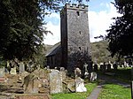 |
| Pont Llanymynech | Carreghofa SJ2682420446 52°46′36″N 3°05′10″W / 52.776644164815°N 3.0862228916463°W / 52.776644164815; -3.0862228916463 (Pont Llanymynech) | 4 May 1993 | Bridge | Main road bridge over River Vyrnwy on S edge of village | 14194 | Upload Photo |
| Aqueduct carrying Montgomeryshire Canal over River Vyrnwy | Carreghofa SJ2540619635 52°46′09″N 3°06′25″W / 52.769160629837°N 3.1070544185044°W / 52.769160629837; -3.1070544185044 (Aqueduct carrying Montgomeryshire Canal over River Vyrnwy) | 4 May 1993 | Aqueduct | Aqueduct parallel to B4398 road bridge over the River Vyrnwy | 14206 |  |
| Llwyncyntefin | Maescar SN9239729413 51°57′10″N 3°34′02″W / 51.952784744452°N 3.5671689501933°W / 51.952784744452; -3.5671689501933 (Llwyncyntefin) | 22 November 1973 | House | Situated some 300m N of Pont Llwyncyntefin on E side of road to Pentre'rfelin. | 14899 | Upload Photo |
| Church of St Cynllo, Llanbister | Llanbister SO1099473308 52°21′02″N 3°18′29″W / 52.350611870372°N 3.3081599866241°W / 52.350611870372; -3.3081599866241 (Church of St Cynllo, Llanbister) | 24 October 1951 | Church | Occupying a steep site in the centre of the village, on the S side of the B4356 | 15013 |  |
| Church of St Michael and All Angels, Clyro | Clyro SO2133543834 52°05′14″N 3°08′58″W / 52.087268387391°N 3.1495128319494°W / 52.087268387391; -3.1495128319494 (Church of St Michael and All Angels, Clyro) | 31 January 1995 | Church | Orientated south west/north east in rubble-walled subcircular churchyard in village centre | 15196 |  See more images |
| Baskerville Hall Hotel | Clyro SO2077642840 52°04′42″N 3°09′27″W / 52.078253717538°N 3.1574382612615°W / 52.078253717538; -3.1574382612615 (Baskerville Hall Hotel) | 31 January 1995 | Hotel | 15314 | Upload Photo | |
| Barn Range North of Clyro Court Farmhouse | Clyro SO2125143365 52°04′59″N 3°09′02″W / 52.083040702203°N 3.1506300597101°W / 52.083040702203; -3.1506300597101 (Barn Range North of Clyro Court Farmhouse) | 25 February 1952 | Barn | Set at a slight angle alongside the service road to Clyro Court Farm from the village of Clyro. | 15316 | Upload Photo |
| Attached Gateway north of Clyro Court Farmhouse | Clyro SO2124143297 52°04′57″N 3°09′03″W / 52.082428042523°N 3.1507602357547°W / 52.082428042523; -3.1507602357547 (Attached Gateway north of Clyro Court Farmhouse) | 25 February 1952 | Gateway | Set at a slight angle alongside the service road to Clyro Court Farm from the village of Clyro. | 15317 | Upload Photo |
| Church of Holy Trinity, Bettws | Clyro SO2278547325 52°07′08″N 3°07′45″W / 52.11885278677°N 3.1291474284623°W / 52.11885278677; -3.1291474284623 (Church of Holy Trinity, Bettws) | 31 January 1995 | Church | Situated 4km north east of Clyro, and 1.5km west of Rhydspence. | 15318 |  |
| Cabalva House | Clyro SO2402446712 52°06′49″N 3°06′39″W / 52.113514634958°N 3.1109184820038°W / 52.113514634958; -3.1109184820038 (Cabalva House) | 31 January 1995 | Country House | 15326 |  | |
| Lower Rabber, Gladestry | Gladestry SO2513854348 52°10′56″N 3°05′47″W / 52.182305421317°N 3.0963387182182°W / 52.182305421317; -3.0963387182182 (Lower Rabber, Gladestry) | 31 January 1995 | House | 15342 | Upload Photo | |
| Footbridge and boundary wall on N side of Leighton Hall | Forden SJ2415804706 52°38′05″N 3°07′20″W / 52.634806485212°N 3.1221002895534°W / 52.634806485212; -3.1221002895534 (Footbridge and boundary wall on N side of Leighton Hall) | 24 December 1982 | Footbridge | Located on the N boundary of the landscape gardens of Leighton Hall, with the Serpentine Pond immediately to S. | 15627 | Upload Photo |
| Footbridge E of Leighton Hall Tower | Forden SJ2419604585 52°38′01″N 3°07′17″W / 52.633724258184°N 3.1215110902055°W / 52.633724258184; -3.1215110902055 (Footbridge E of Leighton Hall Tower) | 24 December 1982 | Footbridge | Situated E of Leighton Hall Tower, S of Serpentine Pond and NE of a terrace walk at Leighton Hall. | 15628 | Upload Photo |
| Grotto at Maesfron House | Trewern SJ2811611426 52°41′45″N 3°03′54″W / 52.695746325798°N 3.0650950688845°W / 52.695746325798; -3.0650950688845 (Grotto at Maesfron House) | 24 January 1995 | Grotto | Built into the steep bank in the gardens of Maesfron House. | 15641 |  |
| Llwyn Melyn Farmhouse | Trewern SJ2878211168 52°41′37″N 3°03′19″W / 52.693515570466°N 3.055186298095°W / 52.693515570466; -3.055186298095 (Llwyn Melyn Farmhouse) | 3 November 1981 | Farmhouse | 15645 | Upload Photo | |
| Llandinam Bridge | Llandinam SO0252188585 52°29′11″N 3°26′13″W / 52.486465999933°N 3.4369728283436°W / 52.486465999933; -3.4369728283436 (Llandinam Bridge) | 15 February 1994 | Bridge | Set at right angles to the main A.470 on the northern edge of Llandinam village, and carrying the by-road west over the River Severn. | 15653 |  |
| Statue and pedestal, to David Davies of Llandinam | Llandinam SO0253588595 52°29′12″N 3°26′12″W / 52.486558376731°N 3.4367696551215°W / 52.486558376731; -3.4367696551215 (Statue and pedestal, to David Davies of Llandinam) | 3 October 1953 | Statue | Situated at the roadside, set back from the eastern end of Llandinam Bridge. | 15654 |  |
| Park Farmhouse, Groes-Lwyd | Guilsfield SJ2019711294 52°41′36″N 3°10′56″W / 52.693448719591°N 3.1822130290302°W / 52.693448719591; -3.1822130290302 (Park Farmhouse, Groes-Lwyd) | 22 February 1995 | Farmhouse | 15807 | Upload Photo | |
| Maesmawr Hall, Guilsfield | Guilsfield SJ1667209660 52°40′42″N 3°14′02″W / 52.678231170546°N 3.2339421365877°W / 52.678231170546; -3.2339421365877 (Maesmawr Hall, Guilsfield) | 22 February 1995 | House | 15810 | Upload Photo | |
| Goetre, Pentre | Meifod SJ1474913787 52°42′54″N 3°15′48″W / 52.715022595166°N 3.2634485160178°W / 52.715022595166; -3.2634485160178 (Goetre, Pentre) | 26 May 1995 | House | 15990 | Upload Photo | |
| Llangwathan Farmhouse | Llanigon SO2446740311 52°03′22″N 3°06′11″W / 52.056037610286°N 3.1030306173873°W / 52.056037610286; -3.1030306173873 (Llangwathan Farmhouse) | 20 June 1995 | Farmhouse | 16127 | Upload Photo | |
| Craig Coch Dam and valve tower, Elan Valley | Rhayader SN8936468669 52°18′18″N 3°37′27″W / 52.304978058208°N 3.6240652719537°W / 52.304978058208; -3.6240652719537 (Craig Coch Dam and valve tower, Elan Valley) | 31 July 1995 | Dam/Valve tower | 16198 |  See more images | |
| Penygarreg Dam and valve tower, Elan Valley | Rhayader SN9113767414 52°17′39″N 3°35′52″W / 52.294054731872°N 3.5976666076577°W / 52.294054731872; -3.5976666076577 (Penygarreg Dam and valve tower, Elan Valley) | 31 July 1995 | Dam/Valve tower | 16199 |  | |
| Carreg ddu Viaduct | Rhayader SN9103963955 52°15′47″N 3°35′53″W / 52.262950100999°N 3.5979840653995°W / 52.262950100999; -3.5979840653995 (Carreg ddu Viaduct) | 31 July 1995 | Dam/Viaduct | About 7km SW of Rhayader centre. Carries road from Elan valley to Claerwen valley | 16200 | 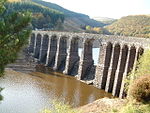 |
| Foel Valve Tower, Elan Valley | Rhayader SN9106164071 52°15′50″N 3°35′52″W / 52.263996933353°N 3.5976993271379°W / 52.263996933353; -3.5976993271379 (Foel Valve Tower, Elan Valley) | 31 July 1995 | Valve tower | Near NE end of Carreg Ddu viaduct. | 16201 |  See more images |
| Caban Coch Dam | Rhayader SN9247164475 52°16′04″N 3°34′38″W / 52.26790563862°N 3.5771761349689°W / 52.26790563862; -3.5771761349689 (Caban Coch Dam) | 31 July 1995 | Dam | About 6km SW of Rhayader centre. | 16202 |  See more images |
| Lower Cil Farmhouse, Cil | Berriew SJ1825501604 52°36′22″N 3°12′31″W / 52.606067898198°N 3.2085357954072°W / 52.606067898198; -3.2085357954072 (Lower Cil Farmhouse, Cil) | 21 August 1995 | Farmhouse | 16363 | Upload Photo | |
| Stable block at Vaynor Park | Berriew SJ1758700205 52°35′36″N 3°13′05″W / 52.593392951783°N 3.2180485528291°W / 52.593392951783; -3.2180485528291 (Stable block at Vaynor Park) | 21 August 1995 | Stable | 16401 | Upload Photo | |
| Former Powysland Museum & Library | Welshpool SJ2260707682 52°39′41″N 3°08′45″W / 52.661335064974°N 3.1457124156724°W / 52.661335064974; -3.1457124156724 (Former Powysland Museum & Library) | 29 February 1996 | Museum | Built around 2 sides of No 1 Salop Road, with the museum facing Salop Road, and the library facing onto Red Bank. | 16704 | 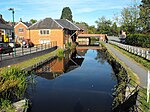 |
| Statue of Fame in entrance courtyard at Powis Castle | Welshpool SJ2154906414 52°38′59″N 3°09′40″W / 52.649786153949°N 3.1610496278299°W / 52.649786153949; -3.1610496278299 (Statue of Fame in entrance courtyard at Powis Castle) | 29 February 1996 | Statue | Forms the centrepiece of the courtyard on the W side of the castle | 16785 |  |
| Statue of Hercules at E of Top Terrace in Powis Castle Gardens | Welshpool SJ2164706490 52°39′02″N 3°09′35″W / 52.650483422197°N 3.1596194581387°W / 52.650483422197; -3.1596194581387 (Statue of Hercules at E of Top Terrace in Powis Castle Gardens) | 29 February 1996 | Statue | Towards the E end of the top terrace of the gardens, close to the great yew hedge. | 16786 | Upload Photo |
| Powis Estate Sawmill with cast-iron launder | Welshpool SJ2216105857 52°38′42″N 3°09′07″W / 52.644868248121°N 3.1518738658376°W / 52.644868248121; -3.1518738658376 (Powis Estate Sawmill with cast-iron launder) | 29 February 1996 | Sawmill | Alongside the road 1.6km approx. S of Welshpool. | 16797 | Upload Photo |
| Detached belltower at the church of St. Mary | Bronllys SO1439234914 52°00′22″N 3°14′55″W / 52.006058963476°N 3.2485817718051°W / 52.006058963476; -3.2485817718051 (Detached belltower at the church of St. Mary) | 28 September 1961 | Belltower | Located within the churchyard of the Church of St. Mary, approximately 10m NE of the chancel. | 16833 |  |
| Church of St Llwchaiarn, Llandyssil | Llandyssil SO1577993173 52°31′48″N 3°14′35″W / 52.529913769706°N 3.2429438637128°W / 52.529913769706; -3.2429438637128 (Church of St Llwchaiarn, Llandyssil) | 26 October 1953 | Church | Located on a narrow lane 400m N of Llanmerewig village to the east of Church Farm. The church is situated in an oval churchyard bounded by a masonry wall. | 17008 | 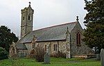 |
| Stable Block at Gwernyfed High School | Gwernyfed SO1758437382 52°01′43″N 3°12′10″W / 52.02872702575°N 3.2026858752647°W / 52.02872702575; -3.2026858752647 (Stable Block at Gwernyfed High School) | 1 May 1976 | Stable | Located on the NE side of the front forecourt to Gwernyfed High School (Gwernyfed Park), and attached to the N corner of the house. | 17047 | Upload Photo |
| South tower in the inner front garden with garden wall running to SW ring of the house | Gwernyfed SO1827036517 52°01′16″N 3°11′33″W / 52.021053508871°N 3.1924824372748°W / 52.021053508871; -3.1924824372748 (South tower in the inner front garden with garden wall running to SW ring of the house) | 28 September 1961 | Tower | Located at the SE corner of the inner courtyard in front of Old Gwernyfed. | 17051 | Upload Photo |
| Gatepiers to inner court in front of Old Gwernyfed with garden walls on each side | Gwernyfed SO1828236531 52°01′16″N 3°11′32″W / 52.021181121692°N 3.1923109470877°W / 52.021181121692; -3.1923109470877 (Gatepiers to inner court in front of Old Gwernyfed with garden walls on each side) | 28 September 1961 | Gate Piers | Located axially on the approaching driveway to the main SE front of Old Gwernyfed, and placed symmetrically between the corner towers. | 17052 | 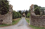 |
| Boughrood Court | Glasbury SO1271039383 52°02′45″N 3°16′27″W / 52.045965760974°N 3.2742207069463°W / 52.045965760974; -3.2742207069463 (Boughrood Court) | 18 January 1996 | House | Located 100m to the NW of Boughrood church across a small tributary of the River Wye, within its own grounds, and with its farmyard, buildings and mill to the N. | 17187 |  |
| Boughrood Cottage | Glasbury SO1270639360 52°02′45″N 3°16′27″W / 52.04575839701°N 3.274273134835°W / 52.04575839701; -3.274273134835 (Boughrood Cottage) | 18 January 1996 | House | Located 100m to the NW of Boughrood church across a small tributary of the River Wye, within its own grounds, and with its farmyard, buildings and mill to the N. | 17188 | Upload Photo |
| Gregynog Hall | Tregynon SO0844697481 52°34′03″N 3°21′08″W / 52.56744597866°N 3.3521986498493°W / 52.56744597866; -3.3521986498493 (Gregynog Hall) | 9 June 1996 | Country House | 1.7km SW of parish church, in a large area of parkland and gardens. The house faces roughly SE. | 17256 |  See more images |
| Plas Dinam | Llandinam SO0296989105 52°29′28″N 3°25′50″W / 52.491219311121°N 3.430529201462°W / 52.491219311121; -3.430529201462 (Plas Dinam) | 26 November 1996 | House | Plas Dinam stands on an elevated plateau above the valley of the Severn, about 1Km N of the village centre. It is approached from a formal driveway from the A470 Caersws to Llanidloes road. | 17771 | Upload Photo |
| Glyn Celyn | Felinfach SO0857632727 51°59′08″N 3°19′58″W / 51.985472502951°N 3.3327032019118°W / 51.985472502951; -3.3327032019118 (Glyn Celyn) | 29 November 1995 | House | To W of A470, approximately 1km SW of Felinfach, in its own grounds. | 17921 | Upload Photo |
| Brynderwen Bridge and Bridge 147 over the Montgomeryshire Canal | Llandyssil SO1621395171 52°32′53″N 3°14′13″W / 52.547938362236°N 3.2370526729363°W / 52.547938362236; -3.2370526729363 (Brynderwen Bridge and Bridge 147 over the Montgomeryshire Canal) | 14 July 1997 | Bridge | Two bridges on the B4368 which links the A483 and Abermule village. Brynderwen bridge crosses the River Severn, to the E of bridge 147 over the Montgomeryshire canal. | 18513 | 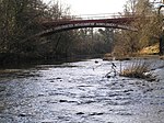 See more images |
| Carmel Independent Chapel | Nantmel SO0541566577 52°17′21″N 3°23′17″W / 52.289180909628°N 3.3881471172865°W / 52.289180909628; -3.3881471172865 (Carmel Independent Chapel) | 11 April 1997 | Chapel | Set back on the N side of a minor road N of the A44, approximately 2km ENE of Nantmel. | 19016 |  |
| Threshing Barn and Granary, Leighton Farm | Forden SJ2425705257 52°38′23″N 3°07′15″W / 52.63977271714°N 3.1207643452839°W / 52.63977271714; -3.1207643452839 (Threshing Barn and Granary, Leighton Farm) | 24 December 1982 | Barn | Situated in the centre of Leighton Farm with Stockyards I and II to NE and NW respectively, and Stockyard IV to S. | 19507 | Upload Photo |
| Cart Shed, Leighton Farm | Forden SJ2429205232 52°38′22″N 3°07′13″W / 52.639552911536°N 3.1202414832571°W / 52.639552911536; -3.1202414832571 (Cart Shed, Leighton Farm) | 20 March 1998 | Cart Shed | Situated within the main group of buildings at Leighton Farm. The Cart Shed stands immediately W of the former Root Shed and N of Maes-y-Gro. On its W side is a small yard with farm road. | 19508 | Upload Photo |
| Mill and Tank House, Leighton Farm | Forden SJ2425805322 52°38′25″N 3°07′15″W / 52.640357075685°N 3.1207645073432°W / 52.640357075685; -3.1207645073432 (Mill and Tank House, Leighton Farm) | 20 March 1998 | Mill | Towards N end of Leighton Farm with Piggery and Sheep Shed to N, farm road and Stockyards I and II to S, and with Granary attached to S side above the road. | 19509 |  See more images |
| Stockyard I, Leighton Farm | Forden SJ2427805274 52°38′24″N 3°07′14″W / 52.639928449456°N 3.1204579789355°W / 52.639928449456; -3.1204579789355 (Stockyard I, Leighton Farm) | 20 March 1998 | Stockyard | On the E side of Leighton Farm with a farm road to N, a minor road to E, a Fodder Storage Building to S. The upper level of the W range is the Granary attached to the Threshing Barn and Mill and is the partition between Stockyard I and Stockyard II. | 19510 | Upload Photo |
| Stockyard II, Leighton Farm | Forden SJ2423905274 52°38′24″N 3°07′16″W / 52.639922995022°N 3.1210342000413°W / 52.639922995022; -3.1210342000413 (Stockyard II, Leighton Farm) | 20 March 1998 | Stockyard | On the W side of Leighton Farm with Stockyard III to W, Hay Storage Building to S. The upper level of the E range is the Granary attached to the Threshing Barn and Mill. The E range is also the partition between Stockyard I and Stockyard II. | 19511 | Upload Photo |
| Stockyard III, Leighton Farm | Forden SJ2420805270 52°38′24″N 3°07′17″W / 52.639882705534°N 3.1214913020225°W / 52.639882705534; -3.1214913020225 (Stockyard III, Leighton Farm) | 20 March 1998 | Stockyard | On the W side of Leighton Farm with a farm road on N and W sides. On E side is Stockyard II and Hay Storage Building; to S are further stockhouses. | 19512 | 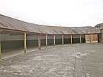 See more images |
| Hay Storage Building, Leighton Farm | Forden SJ2422005260 52°38′23″N 3°07′17″W / 52.63979450502°N 3.1213117043247°W / 52.63979450502; -3.1213117043247 (Hay Storage Building, Leighton Farm) | 20 March 1998 | Barn | On W side of Leighton Farm with Threshing Barn to E, Stockyard II to N, Stockyard III to W and stockhouses to S. | 19513 |  See more images |
| Stockyard IV, Leighton Farm | Forden SJ2425605231 52°38′22″N 3°07′15″W / 52.639538889791°N 3.1207731453557°W / 52.639538889791; -3.1207731453557 (Stockyard IV, Leighton Farm) | 20 March 1998 | Stockyard | Situated in the centre of Leighton Farm with Threshing Barn to N and Stable to S. | 19514 | Upload Photo |
| Former Office and Stock Houses N of Poolton and Gortheur, Leighton Farm | Forden SJ2421005240 52°38′23″N 3°07′17″W / 52.639613346088°N 3.1214548540679°W / 52.639613346088; -3.1214548540679 (Former Office and Stock Houses N of Poolton and Gortheur, Leighton Farm) | 20 March 1998 | Office | Situated on the W side of Leighton Farm with farm road to W, Stockyard III and Hay Storage Building attached to N, and Poolton and Gortheur attached to S. | 19515 |  See more images |
| Stable, Leighton Farm | Forden SJ2425505216 52°38′22″N 3°07′15″W / 52.639403930221°N 3.1207844731309°W / 52.639403930221; -3.1207844731309 (Stable, Leighton Farm) | 20 March 1998 | Stable | Situated at S end of Leighton Farm, fronting a minor road through Leighton. The building is attached to Stockyard IV on N side. | 19516 | Upload Photo |
| West Stockhouse, Leighton Farm | Forden SJ2418705258 52°38′23″N 3°07′18″W / 52.639771910449°N 3.1217988143905°W / 52.639771910449; -3.1217988143905 (West Stockhouse, Leighton Farm) | 20 March 1998 | Stockhouse | Situated at the W end of Leighton Farm with a walled yard to W and farm road to E. | 19517 | Upload Photo |
| Former Sheep-Drying Shed, with attached walls, Leighton Farm | Forden SJ2419605325 52°38′25″N 3°07′18″W / 52.640375364726°N 3.1216812498949°W / 52.640375364726; -3.1216812498949 (Former Sheep-Drying Shed, with attached walls, Leighton Farm) | 20 March 1998 | Sheep Shed | Situated on the NW side of Leighton Farm, with Piggery and Sheep Shed to E. Its attached wall continues S as West Stockyard Wall. | 19519 | Upload Photo |
| Footbridge E of Serpentine Pond at Leighton Hall | Forden SJ2422904682 52°38′05″N 3°07′16″W / 52.634600710076°N 3.1210458787328°W / 52.634600710076; -3.1210458787328 (Footbridge E of Serpentine Pond at Leighton Hall) | 24 December 1982 | Footbridge | Situated to the E of the Serpentine Pond, on the NE side of the landscape gardens at Leighton Hall. | 19531 | Upload Photo |
| Church of All Saints, Forden | Forden SJ2635903935 52°37′41″N 3°05′22″W / 52.628180380006°N 3.0894120703817°W / 52.628180380006; -3.0894120703817 (Church of All Saints, Forden) | 26 October 1953 | Church | Isolated building high up on Long Mountain and situated E of a minor road between Leighton and Marton. The church is reached down a private track and has a woodland plantation to its E. | 19546 | Upload Photo |
| Stable courtyard at Treberfydd | Llangors SO1291525529 51°55′17″N 3°16′04″W / 51.921471425577°N 3.2677106734291°W / 51.921471425577; -3.2677106734291 (Stable courtyard at Treberfydd) | 17 January 1963 | Stable | Attached to the NW side of Treberfydd mansion with main entrance from front terrace; also rear drive entrance. | 20284 | Upload Photo |
| Cathedine Fawr farmhouse including attached kitchen and granary range | Llangors SO1460526081 51°55′36″N 3°14′36″W / 51.926695437641°N 3.2432799138195°W / 51.926695437641; -3.2432799138195 (Cathedine Fawr farmhouse including attached kitchen and granary range) | 21 August 1998 | Farmhouse | On rising ground overlooking Llangorse Lake from E, just above the main road to Llangorse village and N of the hamlet of Cathedine. | 20285 | Upload Photo |
| Two granaries at Ty Mawr | Llangors SO1243626030 51°55′33″N 3°16′29″W / 51.925899432471°N 3.2748015334788°W / 51.925899432471; -3.2748015334788 (Two granaries at Ty Mawr) | 21 August 1998 | Granary | Standing side by side and linked by a screen wall. Forming the S side of a courtyard for Ty Mawr, reached by a farm track. | 20312 | Upload Photo |
| Tretower Court Barn | Llanfihangel Cwmdu with Bwlch and Cathedine SO1862121198 51°53′00″N 3°11′01″W / 51.883405341682°N 3.1837358188791°W / 51.883405341682; -3.1837358188791 (Tretower Court Barn) | 21 October 1998 | Barn | 100m S of Tretower church and on E side of a minor road opposite Tretower Court. | 20660 | Upload Photo |
| Glanusk Bridge | Llanfihangel Cwmdu with Bwlch and Cathedine SO1921019912 51°52′19″N 3°10′30″W / 51.871931341281°N 3.1748789746028°W / 51.871931341281; -3.1748789746028 (Glanusk Bridge) | 21 October 1998 | Bridge | On the S side of Penmyarth Park. The bridge crosses the river Usk with a lodge at its S end. | 20666 |  |
| Tower Lodge and Glanusk Bridge (partly in Llanfihangel Cwmdu with Bwlch and Cathedine community) | Llangattock SO1921919857 51°52′17″N 3°10′29″W / 51.871438253016°N 3.1747353939656°W / 51.871438253016; -3.1747353939656 (Tower Lodge and Glanusk Bridge (partly in Llanfihangel Cwmdu with Bwlch and Cathedine community)) | 21 October 1998 | Lodge and Bridge | The lodge and bridge are located towards the N side of Glanusk Park. The bridge crosses the River Usk with the lodge at its S end. | 20689 | |
| Bank of Limekilns | Llangattock SO2062517282 51°50′55″N 3°09′13″W / 51.848493636854°N 3.1537256801629°W / 51.848493636854; -3.1537256801629 (Bank of Limekilns) | 21 October 1998 | Limekiln | Located immediately N of Upper Yard Bridge (Canal Bridge No 115), on the W side of the Monmouthshire and Brecon Canal. | 20706 | 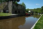 |
| The Stable Court | Llangattock SO1941419522 51°52′06″N 3°10′19″W / 51.868455199475°N 3.1718254156975°W / 51.868455199475; -3.1718254156975 (The Stable Court) | 21 October 1998 | House | Located in the centre of Glanusk Park, to the SW of the site of the former house, and NE of the Home Farm. | 20715 | Upload Photo |
| Llan Wysg | Llangattock SO2058818764 51°51′43″N 3°09′17″W / 51.861810177477°N 3.1546037224328°W / 51.861810177477; -3.1546037224328 (Llan Wysg) | 21 October 1998 | House | Situated to the NW of Dardy hamlet, on the N side of the B4558 road, where the ground slopes down to the River Usk. The house is approached by a driveway from the SE. | 20723 | Upload Photo |
| 'Peach House' at Plas Llangattwg including attached former boiler-house | Llangattock SO2125017837 51°51′13″N 3°08′41″W / 51.853571284563°N 3.1447809065703°W / 51.853571284563; -3.1447809065703 ('Peach House' at Plas Llangattwg including attached former boiler-house) | 21 October 1998 | House | Located in the kitchen gardens at Plas Llangattwg. The W end of the structure forms part of a long masonry wall which divides the formal gardens from the kitchen gardens. | 20726 | Upload Photo |
| Church of St Meugan, Talybont on Usk | Talybont-on-Usk SO0867324537 51°54′43″N 3°19′45″W / 51.911874029837°N 3.3291124353758°W / 51.911874029837; -3.3291124353758 (Church of St Meugan, Talybont on Usk) | 17 January 1963 | Church | At Llanfeugan, in an isolated position SW of the hamlet of Pencelli, on the W bank of a deep-cutting stream, surrounded by an elliptical churchyard with stone stile entrance. | 21105 |  |
| Limekilns at Brynhyfryd | Talybont-on-Usk SO1170022391 51°53′35″N 3°17′04″W / 51.893073600573°N 3.2845679561897°W / 51.893073600573; -3.2845679561897 (Limekilns at Brynhyfryd) | 17 December 1998 | Limekiln | On the S bank of the Canal, within the grounds of Brynhyfryd, on the E edge of the village of Talybont. | 21108 |  |
| The Tennis Pavilion | Talybont-on-Usk SO1325521653 51°53′12″N 3°15′42″W / 51.886684614356°N 3.2617911580137°W / 51.886684614356; -3.2617911580137 (The Tennis Pavilion) | 17 December 1998 | Pavilion | At the foot of Buckland Hill on the lane leading to the rear of Buckland Hall, facing the park. | 21158 | Upload Photo |
| Castle Farm farmhouse | Talybont on Usk SO0947024930 51°54′56″N 3°19′03″W / 51.915536843953°N 3.3176325007315°W / 51.915536843953; -3.3176325007315 (Castle Farm farmhouse) | 17 December 1998 | Farmhouse | On the E side of Pencelli village surrounded on 3 sides by the former castle earthworks with the canal bordering these to N. | 21163 | Upload Photo |
| Glan Ithon, including attached farm buildings | Llanyre SO0585263874 52°15′54″N 3°22′52″W / 52.264962506984°N 3.3809866753066°W / 52.264962506984; -3.3809866753066 (Glan Ithon, including attached farm buildings) | 18 June 1999 | House | Approximately 2km NE of Llanyre, reached by drive on the SE side of a minor road between Llanyre and Crossgates. | 21878 | Upload Photo |
| Capel Seion including Railings | Llanrhaeadr ym Mochnant (S) SJ1223126099 52°49′31″N 3°18′14″W / 52.825269437157°N 3.3040162259604°W / 52.825269437157; -3.3040162259604 (Capel Seion including Railings) | 18 July 2000 | Chapel | Situated on the N side of the square just W of the bridge in the centre of Llanrhaeadr-ym-Mochnant. | 23524 | 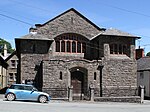 See more images |
| Eglwys Oen Duw | Treflys SN9134052113 52°09′24″N 3°35′23″W / 52.156587074982°N 3.5897708028164°W / 52.156587074982; -3.5897708028164 (Eglwys Oen Duw) | 30 October 2000 | Church | On the E side of a minor road between Beulah and Abergwesyn, approximately 1.2km NW of Beulah village. | 24349 | 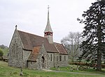 See more images |
| Caban Coch dam (partly in Rhayader community) | Llanwrthwl SN9247364436 52°16′03″N 3°34′38″W / 52.267555542936°N 3.5771343968432°W / 52.267555542936; -3.5771343968432 (Caban Coch dam (partly in Rhayader community)) | 31 July 1995 | Dam | Approximately 6km SW of Rhayader. | 24389 | See more images |
| Church of St David, Llanwrtyd Wells | Llanwrtyd Wells SN8636047793 52°07′00″N 3°39′40″W / 52.116760105427°N 3.6610887589104°W / 52.116760105427; -3.6610887589104 (Church of St David, Llanwrtyd Wells) | 19 January 2001 | Church | Located in an exceptional setting in the Irfon valley just above the confluence with the Nant Lletgwial. Set in a large circular churchyard with many monuments. | 24525 |  See more images |
| Cnewr and attached buildings | Cray SN8904622084 51°53′11″N 3°36′49″W / 51.886257642191°N 3.6135454580853°W / 51.886257642191; -3.6135454580853 (Cnewr and attached buildings) | 25 May 2001 | House | Situated on the W side of the A4067 some 2.4 km S of Crai village. | 25198 | Upload Photo |
| Pantycolly including attached byre range | Erwood SO0692140608 52°03′22″N 3°21′32″W / 52.056032534262°N 3.3589411804662°W / 52.056032534262; -3.3589411804662 (Pantycolly including attached byre range) | 8 March 2001 | Farmhouse | Situated some 5 km SW of Crickadarn, the last farm on the lane on the far side of Cefn Llwydallt moorland. | 25663 | Upload Photo |
| Hafod y Garreg | Erwood SO1076241516 52°03′53″N 3°18′11″W / 52.064826970341°N 3.3031751688131°W / 52.064826970341; -3.3031751688131 (Hafod y Garreg) | 8 March 2001 | House | Situated across field from Penygraig, reached by track from just N of Trericket Mill. | 25674 | Upload Photo |
| Canal Aqueduct over Afon Twrch, including weir | Ystradgynlais SN7727009240 51°46′06″N 3°46′48″W / 51.768360945782°N 3.7800051522023°W / 51.768360945782; -3.7800051522023 (Canal Aqueduct over Afon Twrch, including weir) | 12 April 2001 | Aqueduct | Situated some 50m N of Twrch Bridge between Ystradgynlais community and Ystalyfera community, reached by footpath along river from Gurnos Road. | 25953 |  |
| Walls enclosing Kitchen Garden including Vine House and Pineapple House | Trallong SN9704229027 51°57′01″N 3°29′58″W / 51.950196497599°N 3.4994883488552°W / 51.950196497599; -3.4994883488552 (Walls enclosing Kitchen Garden including Vine House and Pineapple House) | 18 January 2002 | Wall | Situated some 150m NW of the bridge reached by winding path through rose garden. | 26095 | Upload Photo |
| Penpont Bridge including two doorways in attached wall to N | Trallong SN9710928827 51°56′54″N 3°29′54″W / 51.94841138333°N 3.498453903005°W / 51.94841138333; -3.498453903005 (Penpont Bridge including two doorways in attached wall to N) | 17 January 1963 | Bridge | Crosses River Usk to NW of house at Penpont. | 26097 | Upload Photo |
| Cwm y Dwrgi | Cadfarch SN7730195817 52°32′47″N 3°48′39″W / 52.546350318241°N 3.8108690253403°W / 52.546350318241; -3.8108690253403 (Cwm y Dwrgi) | 8 July 2002 | House | Located about 6km SE of Machynlleth, in a remote situation above a minor road which runs S from Forge. | 26837 | Upload Photo |
| Dolobran Hall | Llangyniew SJ1184912275 52°42′03″N 3°18′21″W / 52.700968361449°N 3.3059605502194°W / 52.700968361449; -3.3059605502194 (Dolobran Hall) | 19 September 2002 | Hall | 1 km west of Pontrobert village, reached by a lane to the north of the Pontrobert to Mathrafal road. Farmyard at north and west (including listed farm building), garden to south. | 26960 | Upload Photo |
| Parish Church of St Wddyn, Llanwddyn | Llanwddyn SJ0227419285 52°45′44″N 3°26′59″W / 52.76231838039°N 3.4496998669039°W / 52.76231838039; -3.4496998669039 (Parish Church of St Wddyn, Llanwddyn) | 26 February 2003 | Church | 300 m east of the Vyrnwy Dam, in a grassed churchyard in which there are apparently no burials; iron railings and gates. | 80932 |  |
| Church of Saint David, Honddu Isaf | Honddu Isaf SO0456633516 51°59′31″N 3°23′29″W / 51.991888381325°N 3.3912971911849°W / 51.991888381325; -3.3912971911849 (Church of Saint David, Honddu Isaf) | 21 July 2003 | Church | In large churchyard at junction of minor roads at Garthbrengy. | 81038 |  |
| Llwyn-onn, Tanat Valley | Llangynog SJ0722926274 52°49′34″N 3°22′42″W / 52.826002857229°N 3.3782772914431°W / 52.826002857229; -3.3782772914431 (Llwyn-onn, Tanat Valley) | 3 April 1974 | House | To the north side of the Afon Tanat, about 2 km east of the village of Llangynog. The upper part of the house is sunk in a hollow and the lower part of the house is built on a raised platform. | 81051 | Upload Photo |
| Church of St Anno, Llanbadarn Fynydd | Llananno, Llanbadarn Fynydd SO0956874345 52°21′35″N 3°19′46″W / 52.359698348907°N 3.3293692922145°W / 52.359698348907; -3.3293692922145 (Church of St Anno, Llanbadarn Fynydd) | 29 July 2004 | Church | In a churchyard set down on the W side of the A483 on the SW side of the entrance to Glanrafon Farm | 82991 |  |
| Church of St Dyfrig, Glantwymyn | Glantwymyn SH7866003528 52°36′57″N 3°47′37″W / 52.615941815135°N 3.7936657778043°W / 52.615941815135; -3.7936657778043 (Church of St Dyfrig, Glantwymyn) | 8 May 2004 | Church | Prominently sited in a raised circular churchyard on the NW side of the village. | 83006 | Upload Photo |
| Esgair Llewelyn | Glantwymyn SH8000508876 52°39′51″N 3°46′33″W / 52.664295079774°N 3.7757559552789°W / 52.664295079774; -3.7757559552789 (Esgair Llewelyn) | 8 May 2004 | House | Located in an upland position in a clearing in the Dyfi Forest and reached by lanes and tracks running N from the B4404 at Mathafarn. | 83013 | Upload Photo |
| Tan y ffordd | Glantwymyn SH8361905955 52°38′20″N 3°43′17″W / 52.638837553724°N 3.7213124663409°W / 52.638837553724; -3.7213124663409 (Tan y ffordd) | 19 December 1951 | House | Located at the end of a short track off the W side of the road, close to the River Dovey. | 83044 | Upload Photo |
| Cruck-framed farm-building at Ystum Colwyn | Meifod SJ1898416337 52°44′19″N 3°12′05″W / 52.738592789421°N 3.2014014058858°W / 52.738592789421; -3.2014014058858 (Cruck-framed farm-building at Ystum Colwyn) | 19 August 2004 | Farm building | Ystum Colwyn. Farm is at the eastern angle of the junction of the A490 and the A495 NE of Meifod. The cruck-framed farm-buildings bounds the SW side of the farmyard, SE of the house. | 83068 | Upload Photo |
| The Hall | Abbeycwmhir SO0547471261 52°19′53″N 3°23′19″W / 52.33128883239°N 3.3885994984326°W / 52.33128883239; -3.3885994984326 (The Hall) | 9 March 2004 | Country House | In its own grounds on an elevated site above the Abbey ruins and to the E side of the parish church. | 83105 |  |
| Doldowlod House | Llanyre SN9980262492 52°15′05″N 3°28′09″W / 52.251471075366°N 3.4691966987882°W / 52.251471075366; -3.4691966987882 (Doldowlod House) | 15 November 2004 | House | In its own grounds on the E bank of the River Wye and the W side of the A470, approximately 6km SSE of Rhayader. | 83227 | Upload Photo |
| Church of Saint Maelog, Honddu Isaf | Llandyfaelog Fach, Honddu Isaf SO0339832387 51°58′54″N 3°24′29″W / 51.981538636715°N 3.4079838299743°W / 51.981538636715; -3.4079838299743 (Church of Saint Maelog, Honddu Isaf) | 16 February 2005 | Church | In a prominent position in the centre of Llandyfaelog Fach between the B4520 and the Afon Honddu. | 83673 |  See more images |
| Glan-Honddu | Honddu Isaf SO0304131957 51°58′39″N 3°24′47″W / 51.977611502675°N 3.4130585551075°W / 51.977611502675; -3.4130585551075 (Glan-Honddu) | 16 February 2005 | House | On the S side of Llandyfaelog Fach at the end of a drive W off the B4520. | 83677 | Upload Photo |
| Y Gribyn | Trefeglwys SN9270391666 52°30′44″N 3°34′57″W / 52.512307518276°N 3.582496080991°W / 52.512307518276; -3.582496080991 (Y Gribyn) | 18 February 2005 | House | Located off the W side of a lane which runs NW up the hillside from Llawr y Glyn; approx 0.8km from the village. | 83707 | Upload Photo |
| Doldowlod House | Nantmel SN9981162488 52°15′05″N 3°28′09″W / 52.251436767938°N 3.4690637193958°W / 52.251436767938; -3.4690637193958 (Doldowlod House) | 15 November 2004 | House | In its own grounds on the E bank of the River Wye and the W side of the A470, approximately 6km SSE of Rhayader. | 84148 | 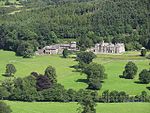 |
| Church of Saint Cadmarch, Llangammarch | Llangammarch Wells SN9351647325 52°06′50″N 3°33′23″W / 52.113981395919°N 3.5564747253931°W / 52.113981395919; -3.5564747253931 (Church of Saint Cadmarch, Llangammarch) | 29 April 2005 | Church | Situated on rocky spur between Irfon and Cammarch rivers, NW of the railway. | 84374 |  |
| Primary House at Rhos Fawr Isaf | Meifod SJ1359014741 52°43′24″N 3°16′51″W / 52.723412337726°N 3.2808522571321°W / 52.723412337726; -3.2808522571321 (Primary House at Rhos Fawr Isaf) | 18 May 2005 | Farmhouse | In the hills that run between the Vyrnwy and Cwm Nant y Meichiad, some 2.5km NW of Meifod. The building is down-hill sited, occupying a prominent rock spur to the SE of the later farmhouse. | 84403 | Upload Photo |
| Dam at the Upper Neuadd Reservoir | Llanfrynach SO0291518769 51°51′33″N 3°24′40″W / 51.859054805242°N 3.4111698411766°W / 51.859054805242; -3.4111698411766 (Dam at the Upper Neuadd Reservoir) | 28 July 2005 | Dam | Situated in the Taf Fechan valley some 9.6 km SW of Llanfrynach. | 84824 |  |
| 6, Glamorgan Street | Brecon SO0455028450 51°56′47″N 3°23′24″W / 51.946352030801°N 3.3901200567964°W / 51.946352030801; -3.3901200567964 (6, Glamorgan Street) | 16 January 1952 | House | The first houses to W of Brecknock Museum. | 85694 | Upload Photo |
| 2, Buckingham Place | Brecon SO0441228487 51°56′48″N 3°23′32″W / 51.946660850331°N 3.3921374850704°W / 51.946660850331; -3.3921374850704 (2, Buckingham Place) | 16 January 1952 | House | 16th-century townhouse, central property of a group forming the SW corner as Glamorgan Street turns N to become Wheat Street. | 85742 | |
| 3, Buckingham Place | Brecon SO0442328479 51°56′48″N 3°23′31″W / 51.94659°N 3.39198°W / 51.94659; -3.39198 (3, Buckingham Place) | 16 January 1952 | House | 16th-century townhouse, part of a group forming the southwest corner as Glamorgan Street turns north to become Wheat Street. | 85745 |  |
| Morgannwg House, including Forecourt Wall and Railings | Brecon SO0449028454 51°56′47″N 3°23′28″W / 51.946377665543°N 3.3909938342135°W / 51.946377665543; -3.3909938342135 (Morgannwg House, including Forecourt Wall and Railings) | 16 January 1952 | House | On S side of street, to E of Havard House (Ursuline Convent) | 85751 |  |
Notes
- ^ Sometimes known as OSGB36, the grid reference is based on the British national grid reference system used by the Ordnance Survey.
See also
 Wales portal

- Grade I listed buildings in Powys
- Scheduled monuments in Powys
- Registered historic parks and gardens in Powys
References
External links
![]() Media related to Grade II* listed buildings in Powys at Wikimedia Commons
Media related to Grade II* listed buildings in Powys at Wikimedia Commons
- v
- t
- e
 Architecture
 Wales
Wales


