List of Grade A listed buildings in County Fermanagh

Map all coordinates using OpenStreetMap
Download coordinates as:
- KML
- GPX (all coordinates)
- GPX (primary coordinates)
- GPX (secondary coordinates)
This is a list of Grade A listed buildings in County Fermanagh, Northern Ireland.
In Northern Ireland, the term listed building refers to a building or other structure officially designated as being of "special architectural or historic interest".[1] Grade A structures are those considered to be "buildings of greatest importance to Northern Ireland including both outstanding architectural set-pieces and the least altered examples of each representative style, period and type."[2]
Listing began later in Northern Ireland than in the rest of the UK; the first provision for listing was contained in the Planning (Northern Ireland) Order 1972,[3] and the current legislative basis for listing is the Planning (Northern Ireland) Order 1991.[4] Under Article 42 of the Order, the Department of the Environment of the Northern Ireland Executive is required to compile lists of buildings of "special architectural or historic interest". The responsibility for the listing process rests with the Northern Ireland Environment Agency (NIEA), an executive agency within the Department of the Environment.[4]
Following the introduction of listing, an initial survey of Northern Ireland's building stock was begun in 1974.[5] By the time of the completion of this First Survey in 1994, the listing process had developed considerably, and it was therefore decided to embark upon a Second Survey to update and cross-check the original information. As of April 2010[update], the Second Survey had been completed for 147 of Northern Ireland's 547 council wards, and completion is anticipated by 2016.[5] Information gathered during this survey, relating to both listed and unlisted buildings, is entered into the publicly accessible Northern Ireland Buildings Database.[5] A range of listing criteria, which aim to define architectural and historic interest, have been developed by the NIEA, and are used to determine whether or not to list a building.[4]
Once listed, severe restrictions are imposed on the modifications allowed to a building's structure or its fittings. Listed building consent must be obtained from local authorities prior to any alteration to such a structure.[6] There are approximately 8,500 listed buildings in Northern Ireland, representing 2% of the total building stock.[4] Of these, around 200 are listed at Grade A.
County Fermanagh covers 1,691 square kilometres (653 sq mi), and has a population of around 57,500. The County has nine Grade A listed buildings.
Listed buildings
| Building address | Grid Ref.[note 1] Geo-coordinates | Type [note 2] | Local authority | Second Survey | Original Survey | HB Number [note 3] | Image |
|---|---|---|---|---|---|---|---|
| Knockballymore, Magheraveely, Enniskillen | 54°11′28″N 7°15′53″W / 54.1911°N 7.2646°W / 54.1911; -7.2646 (Knockballymore, Magheraveely, Enniskillen) | House | Fermanagh | A | B+ | HB12/01/001 A |  Upload Photo
|
| Crom Castle, Newtownbutler | 54°10′06″N 7°26′57″W / 54.1684°N 7.4492°W / 54.1684; -7.4492 (Crom Castle, Newtownbutler) | Country House | Fermanagh | A | A | HB12/02/002 A |  Upload another image
|
| Conservatory, Colebrook Kitchen Garden, Colebrook, Brookeborough | 54°20′57″N 7°22′02″W / 54.349167°N 7.367222°W / 54.349167; -7.367222 (Conservatory, Colebrook Kitchen Garden, Colebrook, Brookeborough) | Glass House | Fermanagh | A | HB12/04/010 A | Upload Photo
| |
| Cottage at Corry Townland, Teemore, Derrylin | 54°08′22″N 7°30′58″W / 54.1394°N 7.5161°W / 54.1394; -7.5161 (Cottage at Corry Townland, Teemore, Derrylin) | House | Fermanagh | A | B1 | HB12/08/013 | Upload Photo
|
| Florence Court, near Enniskillen | 54°15′40″N 7°43′39″W / 54.261111°N 7.7275°W / 54.261111; -7.7275 (Florence Court, near Enniskillen) | Country House | Fermanagh | A | HB12/09/002 |  Upload another image
| |
| 175 Boho Road, Mullylusty, Belcoo, Enniskillen | 54°19′35″N 7°51′47″W / 54.3265°N 7.8631°W / 54.3265; -7.8631 (175 Boho Road, Mullylusty, Belcoo, Enniskillen) | House | Fermanagh | A | A | HB12/10/002 | 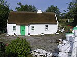 Upload another image
|
| St. Macartin's Cathedral, Church Street, Enniskillen | 54°20′46″N 7°38′26″W / 54.346194°N 7.640444°W / 54.346194; -7.640444 (St. Macartin's Cathedral, Church Street, Enniskillen) | Church | Fermanagh | A | HB12/17/002 | 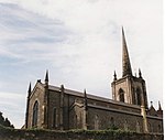 Upload another image
| |
| Castle Coole, Enniskillen | 54°20′10″N 7°36′11″W / 54.336111°N 7.603056°W / 54.336111; -7.603056 (Castle Coole, Enniskillen) | Country House | Fermanagh | A | HB12/17/004 | 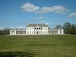 Upload another image
| |
| General Cole Column, Fort Hill, Enniskillen | 54°20′43″N 7°37′55″W / 54.345375°N 7.631808°W / 54.345375; -7.631808 (General Cole Column, Fort Hill, Enniskillen) | Memorial | Fermanagh | A | HB12/20/001 |  Upload another image |
Notes
Wikimedia Commons has media related to Grade A listed buildings in County Fermanagh.
- ^ Sometimes known as OSGB36, the grid reference is based on the British national grid reference system used by the Ordnance Survey.
- ^ The type of structure, as identified by the DfC.
- ^ The "HB Number" is a unique number assigned to each listed building by the DfC.
References
- ^ "The Listing Process" (PDF). Northern Ireland Environment Agency. September 2008. Retrieved 30 June 2010.
- ^ "Planning Policy Statement 6: Planning, Archaeology, and the Built Heritage" (PDF). Planning Service. March 1999. p. 48. Retrieved 30 June 2010.
- ^ Legislation providing for the listing of buildings in England, Wales and Scotland was enacted in 1947.
- ^ a b c d "Criteria for Listing: A consultation on proposed revisions to Annex C of Planning Policy Statement 6" (PDF). Northern Ireland Environment Agency. 2010. Archived from the original (PDF) on 8 February 2016. Retrieved 30 June 2010.
- ^ a b c "Second Survey". Northern Ireland Environment Agency. Archived from the original on 25 August 2010. Retrieved 30 June 2010.
- ^ "Planning Policy Statement 6: Planning, Archaeology, and the Built Heritage" (PDF). Planning Service. March 1999. p. 22. Retrieved 30 June 2010.
External links
Map all coordinates using OpenStreetMap
Download coordinates as:
- KML
- GPX (all coordinates)
- GPX (primary coordinates)
- GPX (secondary coordinates)
- Northern Ireland Buildings Database
- v
- t
- e
- County Antrim
- County Armagh
- County Down
- County Fermanagh
- County Londonderry
- County Tyrone


