List of Grade A listed buildings in County Tyrone

Map all coordinates using OpenStreetMap
Download coordinates as:
- KML
- GPX (all coordinates)
- GPX (primary coordinates)
- GPX (secondary coordinates)
This is a list of Grade A listed buildings in County Tyrone, Northern Ireland.
In Northern Ireland, the term listed building refers to a building or other structure officially designated as being of "special architectural or historic interest".[1] Grade A structures are those considered to be "buildings of greatest importance to Northern Ireland including both outstanding architectural set-pieces and the least altered examples of each representative style, period and type."[2] Once listed, severe restrictions are imposed on the modifications allowed to a building's structure or its fittings. Listed building consent must be obtained from local authorities prior to any alteration to such a structure.[1]
Listing began later in Northern Ireland than in the rest of the UK: the first provision for listing was contained in the Planning (Northern Ireland) Order 1972;[3] and the current legislative basis for listing is the Planning (Northern Ireland) Order 1991.[2] Under Article 42 of the Order, the relevant Department of the Northern Ireland Executive is required to compile lists of buildings of "special architectural or historic interest". Since 2016, the responsibility for the listing process rests with the Historic Environment Division of the Department for Communities (DfC).[4]
Following the introduction of listing, an initial survey of Northern Ireland's building stock was begun in 1974.[5] By the time of the completion of this First Survey in 1994, the listing process had developed considerably, and it was therefore decided to embark upon a Second Survey, which is still ongoing, to update and cross-check the original information. Information gathered during this survey, relating to both listed and unlisted buildings, is entered into the publicly accessible Northern Ireland Buildings Database.[5] A range of listing criteria, which aim to define architectural and historic interest, are used to determine whether or not to list a building.[2]
County Tyrone covers 3,155 square kilometres (1,218 sq mi), and has a population of around 166,500. The County has 20 Grade A listed buildings.
Listed buildings
| Building address | Grid Ref.[note 1] Geo-coordinates | Type [note 2] | Local authority | Second Survey | Original Survey | HB Number [note 3] | Image | Ref. |
|---|---|---|---|---|---|---|---|---|
| Killymoon Castle, Cookstown | 54°37′47″N 6°43′39″W / 54.6296°N 6.7275°W / 54.6296; -6.7275 (Killymoon Castle, Cookstown) | Country House | Cookstown | A | B1 | HB09/05/001 A |  Upload Photo | [6] |
| Outbuildings at Killymoon Castle, Cookstown | 54°37′49″N 6°43′35″W / 54.6303°N 6.7264°W / 54.6303; -6.7264 (Outbuildings at Killymoon Castle, Cookstown) | Farm Buildings | Cookstown | A | A | HB09/05/001 B | Upload Photo | [7] |
| Augher Castle, Augher | 54°25′46″N 7°08′07″W / 54.429467°N 7.135228°W / 54.429467; -7.135228 (Augher Castle, Augher) | Country House | Dungannon and South Tyrone | – | A | HB13/03/001 | 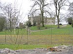 Upload another image | [8] |
| St. John's Church, Church Hill, Caledon | 54°21′10″N 6°50′12″W / 54.352806°N 6.836556°W / 54.352806; -6.836556 (St. John's Church, Church Hill, Caledon) | Church | Dungannon and South Tyrone | – | A | HB13/10/003 | 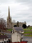 Upload another image | [9] |
| Caledon House, Caledon | 54°20′06″N 6°50′48″W / 54.335°N 6.846667°W / 54.335; -6.846667 (Caledon House, Caledon) | House | Dungannon and South Tyrone | – | A | HB13/10/004 |  Upload another image | [10] |
| Caledon Monument, Caledon | 54°20′46″N 6°50′10″W / 54.346167°N 6.836011°W / 54.346167; -6.836011 (Caledon Monument, Caledon) | Memorial | Dungannon and South Tyrone | – | A | HB13/10/011 | Upload Photo | [11] |
| Gate Screen, Caledon Monument, Caledon | 54°20′48″N 6°50′04″W / 54.346628°N 6.834397°W / 54.346628; -6.834397 (Gate Screen, Caledon Monument, Caledon) | Gates/ Screens/ Lodges | Dungannon and South Tyrone | – | A | HB13/10/012 | Upload Photo | [12] |
| Gateway in Bawn Wall, Augher Castle, Augher | Gates/ Screens/ Lodges | Dungannon and South Tyrone | – | A | HB13/03/002 | Upload Photo | [13] | |
| Bawn Tower, Augher Castle, Augher | 54°25′44″N 7°08′30″W / 54.428889°N 7.141667°W / 54.428889; -7.141667 (Bawn Tower, Augher Castle, Augher) | Tower | Dungannon and South Tyrone | – | A | HB13/03/003 | Upload Photo | [14] |
| St. James Church, The Diamond, Moy | 54°26′51″N 6°41′32″W / 54.4475°N 6.692222°W / 54.4475; -6.692222 (St. James Church, The Diamond, Moy) | Church | Dungannon and South Tyrone | – | A | HB13/08/001 |  Upload another image | [15] |
| St. Macartan's Cathedral, Clogher | 54°24′37″N 7°10′21″W / 54.410206°N 7.172558°W / 54.410206; -7.172558 (St. Macartan's Cathedral, Clogher) | Church | Dungannon and South Tyrone | – | A | HB13/02/001 | 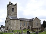 Upload another image | [16] |
| Entrance gates of St. Mary's Church, Favour Royal, Augher | 54°25′09″N 7°03′39″W / 54.419167°N 7.060819°W / 54.419167; -7.060819 (Entrance gates of St. Mary's Church, Favour Royal, Augher) | Gates/ Screens/ Lodges | Dungannon and South Tyrone | – | A | HB13/03/011 | Upload Photo | [17] |
| Clonfeacle Parish Church of St. Patrick, Benburb | 54°24′41″N 6°44′28″W / 54.411325°N 6.741078°W / 54.411325; -6.741078 (Clonfeacle Parish Church of St. Patrick, Benburb) | Church | Dungannon and South Tyrone | – | A | HB13/11/001 |  Upload another image | [18] |
| St. Michael's Church, Castlecaulfield | 54°30′33″N 6°50′09″W / 54.50905°N 6.835708°W / 54.50905; -6.835708 (St. Michael's Church, Castlecaulfield) | Church | Dungannon and South Tyrone | – | A | HB13/13/001 A |  Upload another image | [19] |
| Entrance gates St. Michael's Church, Castlecaulfield | 54°30′33″N 6°50′09″W / 54.50905°N 6.835708°W / 54.50905; -6.835708 (Entrance gates St. Michael's Church, Castlecaulfield) | Gates/ Screens/ Lodges | Dungannon and South Tyrone | – | A | HB13/13/001 B | Upload Photo | [20] |
| Burges Burial Vault, St. Michael's Church, Castlecaulfield | 54°30′33″N 6°50′09″W / 54.50905°N 6.835708°W / 54.50905; -6.835708 (Burges Burial Vault, St. Michael's Church, Castlecaulfield) | Mausoleum | Dungannon and South Tyrone | – | A | HB13/13/001 C | Upload Photo | [21] |
| Parkanaur House, Castlecaulfield | 54°29′49″N 6°51′05″W / 54.497°N 6.851369°W / 54.497; -6.851369 (Parkanaur House, Castlecaulfield) | House | Dungannon and South Tyrone | – | A | HB13/13/002 | 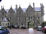 Upload another image | [22] |
| RC Church of The Sacred Heart, Church Street, Omagh | 54°36′03″N 7°18′20″W / 54.600742°N 7.305464°W / 54.600742; -7.305464 (RC Church of The Sacred Heart, Church Street, Omagh) | Church | Omagh | – | A | HB11/11/001 |  Upload another image | [23] |
| Baronscourt House, Newtownstewart | 54°41′32″N 7°26′20″W / 54.692222°N 7.438889°W / 54.692222; -7.438889 (Baronscourt House, Newtownstewart) | House | Strabane | – | A | HB10/04/001 A | 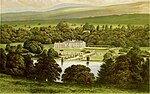 Upload another image | [24] |
Notes
- ^ Sometimes known as OSGB36, the grid reference is based on the British national grid reference system used by the Ordnance Survey.
- ^ The type of structure, as identified by the DfC.
- ^ The "HB Number" is a unique number assigned to each listed building by the DfC.
Wikimedia Commons has media related to Grade A listed buildings in County Tyrone.
References
- ^ a b "Planning Policy Statement 6: Planning, Archaeology, and the Built Heritage" (PDF). Planning Service. March 1999. p. 22. Retrieved 30 June 2010.
- ^ a b c "Planning Policy Statement 6 Planning, Archaeology and the Built Heritage Revised Annex C: Criteria for Listing" (.pdf). DOENI. 2011. Retrieved 8 February 2017.
- ^ Legislation providing for the listing of buildings in England, Wales and Scotland was enacted in 1947.
- ^ "Structure and Contents in the Historic Environment Division" (PDF). Department for Communities. December 2016. Archived from the original (PDF) on 5 January 2017. Retrieved 8 February 2017.
- ^ a b "Second Survey". Department for Communities. Retrieved 8 February 2017.
- ^ Killymoon Castle, Cookstown: Historic Building Details. Northern Ireland Buildings Database. Northern Ireland Environment Agency. Retrieved 2010-06-30.
- ^ Outbuildings at Killymoon Castle, Cookstown: Historic Building Details. Northern Ireland Buildings Database. Northern Ireland Environment Agency. Retrieved 2010-06-30.
- ^ Augher Castle, Augher: Historic Building Details. Northern Ireland Buildings Database. Northern Ireland Environment Agency. Retrieved 2010-06-30.
- ^ St. John's Church, Church Hill, Caledon: Historic Building Details. Northern Ireland Buildings Database. Northern Ireland Environment Agency. Retrieved 2010-06-30.
- ^ Caledon House, Caledon: Historic Building Details. Northern Ireland Buildings Database. Northern Ireland Environment Agency. Retrieved 2010-06-30.
- ^ Caledon Monument, Caledon: Historic Building Details. Northern Ireland Buildings Database. Northern Ireland Environment Agency. Retrieved 2010-06-30.
- ^ Gate Screen, Caledon Monument, Caledon: Historic Building Details. Northern Ireland Buildings Database. Northern Ireland Environment Agency. Retrieved 2010-06-30.
- ^ Gateway in Bawn Wall, Augher Castle, Augher: Historic Building Details. Northern Ireland Buildings Database. Northern Ireland Environment Agency. Retrieved 2010-06-30.
- ^ Bawn Tower, Augher Castle, Augher: Historic Building Details. Northern Ireland Buildings Database. Northern Ireland Environment Agency. Retrieved 2010-06-30.
- ^ St. James Church, The Diamond, Moy: Historic Building Details. Northern Ireland Buildings Database. Northern Ireland Environment Agency. Retrieved 2010-06-30.
- ^ St. Macartan's Cathedral, Clogher: Historic Building Details. Northern Ireland Buildings Database. Northern Ireland Environment Agency. Retrieved 2010-06-30.
- ^ Entrance gates of St. Mary's Church, Favour Royal, Augher: Historic Building Details. Northern Ireland Buildings Database. Northern Ireland Environment Agency. Retrieved 2010-06-30.
- ^ Clonfeacle Parish Church of St. Patrick, Benburb: Historic Building Details. Northern Ireland Buildings Database. Northern Ireland Environment Agency. Retrieved 2010-06-30.
- ^ St. Michael's Church, Castlecaulfield: Historic Building Details. Northern Ireland Buildings Database. Northern Ireland Environment Agency. Retrieved 2010-06-30.
- ^ Entrance gates St. Michael's Church, Castlecaulfield: Historic Building Details. Northern Ireland Buildings Database. Northern Ireland Environment Agency. Retrieved 2010-06-30.
- ^ Burges Burial Vault, St. Michael's Church, Castlecaulfield: Historic Building Details. Northern Ireland Buildings Database. Northern Ireland Environment Agency. Retrieved 2010-06-30.
- ^ Parkanaur House, Castlecaulfield,: Historic Building Details. Northern Ireland Buildings Database. Northern Ireland Environment Agency. Retrieved 2010-06-30.
- ^ RC Church of The Sacred Heart, Church Street, Omagh: Historic Building Details. Northern Ireland Buildings Database. Northern Ireland Environment Agency. Retrieved 2010-06-30.
- ^ Baronscourt House, Newtownstewart: Historic Building Details. Northern Ireland Buildings Database. Northern Ireland Environment Agency. Retrieved 2010-06-30.
External links
Map all coordinates using OpenStreetMap
Download coordinates as:
- KML
- GPX (all coordinates)
- GPX (primary coordinates)
- GPX (secondary coordinates)
- Northern Ireland Buildings Database


